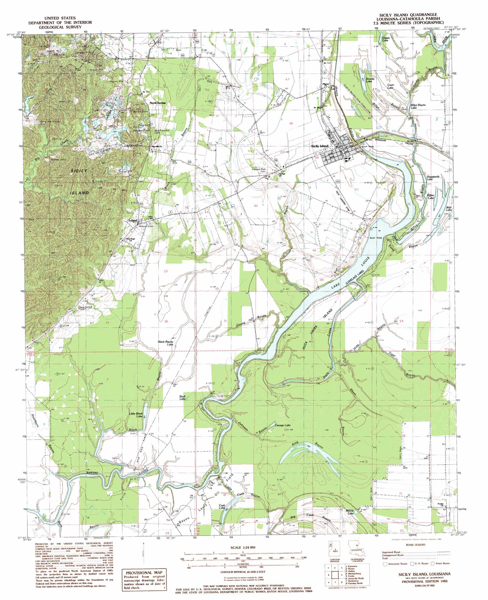
Sicily Island Topo Map Louisiana
To zoom in, hover over the map of Sicily Island
USGS Topo Quad 31091g6 - 1:24,000 scale
| Topo Map Name: | Sicily Island |
| USGS Topo Quad ID: | 31091g6 |
| Print Size: | ca. 21 1/4" wide x 27" high |
| Southeast Coordinates: | 31.75° N latitude / 91.625° W longitude |
| Map Center Coordinates: | 31.8125° N latitude / 91.6875° W longitude |
| U.S. State: | LA |
| Filename: | o31091g6.jpg |
| Download Map JPG Image: | Sicily Island topo map 1:24,000 scale |
| Map Type: | Topographic |
| Topo Series: | 7.5´ |
| Map Scale: | 1:24,000 |
| Source of Map Images: | United States Geological Survey (USGS) |
| Alternate Map Versions: |
Sicily Island SW LA 1976, updated 1977 Download PDF Buy paper map Sicily Island LA 1983, updated 1984 Download PDF Buy paper map Sicily Island LA 2012 Download PDF Buy paper map Sicily Island LA 2015 Download PDF Buy paper map |
1:24,000 Topo Quads surrounding Sicily Island
Mason |
Fort Necessity |
Gilbert |
Como |
Newlight |
Enterprise |
Extension |
Wisner |
Oakley |
Gretna Green |
Aimwell |
Harrisonburg |
Sicily Island |
Foules |
Waterproof |
Manifest |
Jonesville North |
Dunbarton |
Ferriday North |
Spokane |
Walters |
Jonesville South |
Frogmore |
Ferriday South |
Natchez |
> Back to 31091e1 at 1:100,000 scale
> Back to 31090a1 at 1:250,000 scale
> Back to U.S. Topo Maps home
Sicily Island topo map: Gazetteer
Sicily Island: Airports
Peck Landing Strip elevation 22m 72′Sicily Island: Guts
Billys Bayou elevation 12m 39′Duck Creek elevation 11m 36′
Ferry Bayou elevation 13m 42′
Goose Bayou elevation 15m 49′
Hooter Bayou elevation 18m 59′
Johnson Bayou elevation 15m 49′
King Bayou elevation 17m 55′
Sandy Bayou elevation 13m 42′
Sicily Island: Islands
Duck Creek Island elevation 16m 52′Sicily Island: Lakes
Billys Bayou Lake elevation 12m 39′Black Bayou Lake elevation 15m 49′
Brooks Lake elevation 14m 45′
Buck Lake elevation 16m 52′
Cash Lake elevation 13m 42′
Coon Lake elevation 15m 49′
George Lake elevation 15m 49′
Lovelace Lake elevation 10m 32′
Riffee Lake elevation 15m 49′
Sheppards Lake elevation 11m 36′
Well Lake elevation 15m 49′
Willow Lake elevation 13m 42′
Sicily Island: Oilfields
Bayou Louis Oil Field elevation 15m 49′Sicily Island Oil and Gas Field elevation 16m 52′
Sicily Island: Populated Places
Leland elevation 25m 82′Norris Springs elevation 36m 118′
Sicily Island elevation 23m 75′
Sicily Island: Streams
Bayou Falcon elevation 10m 32′Black Bayou elevation 11m 36′
Hawthorn Bayou elevation 10m 32′
Hilde Bayou elevation 12m 39′
Little Cash Bayou elevation 10m 32′
Short Bayou elevation 12m 39′
Tiger Bayou elevation 16m 52′
Sicily Island: Swamps
Little Black Lake elevation 11m 36′Sicily Island digital topo map on disk
Buy this Sicily Island topo map showing relief, roads, GPS coordinates and other geographical features, as a high-resolution digital map file on DVD: