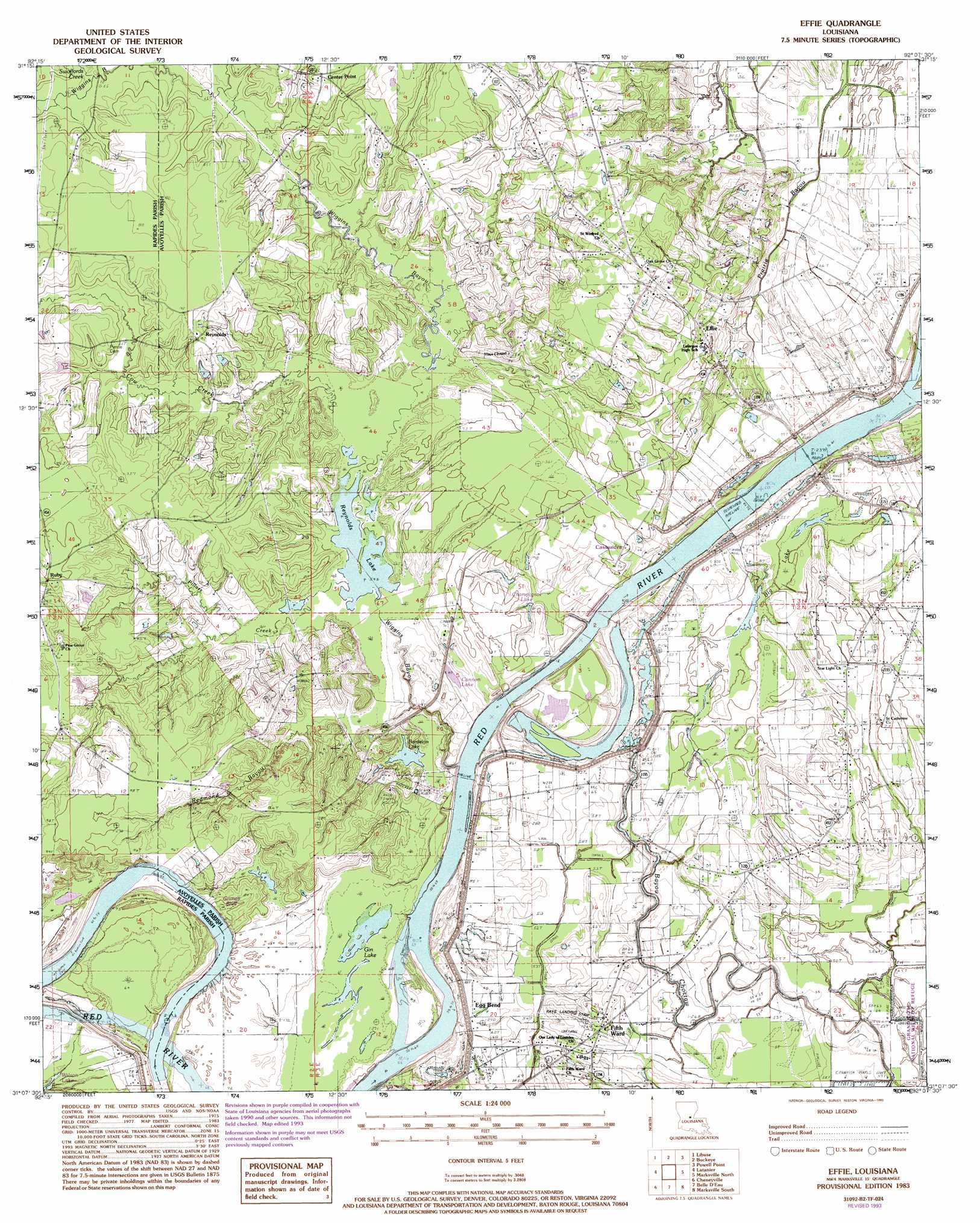
Effie Topo Map Louisiana
To zoom in, hover over the map of Effie
USGS Topo Quad 31092b2 - 1:24,000 scale
| Topo Map Name: | Effie |
| USGS Topo Quad ID: | 31092b2 |
| Print Size: | ca. 21 1/4" wide x 27" high |
| Southeast Coordinates: | 31.125° N latitude / 92.125° W longitude |
| Map Center Coordinates: | 31.1875° N latitude / 92.1875° W longitude |
| U.S. State: | LA |
| Filename: | o31092b2.jpg |
| Download Map JPG Image: | Effie topo map 1:24,000 scale |
| Map Type: | Topographic |
| Topo Series: | 7.5´ |
| Map Scale: | 1:24,000 |
| Source of Map Images: | United States Geological Survey (USGS) |
| Alternate Map Versions: |
Effie LA 1983, updated 1983 Download PDF Buy paper map Effie LA 1993, updated 1993 Download PDF Buy paper map Effie LA 2012 Download PDF Buy paper map Effie LA 2015 Download PDF Buy paper map |
1:24,000 Topo Quads surrounding Effie
Ball |
Green Gables |
Holloway |
Buckeye Ne |
Larto Lake North |
Alexandria |
Libuse |
Buckeye |
Powell Point |
Larto Lake South |
Woodworth East |
Latanier |
Effie |
Marksville North |
Lac Sainte Agnes |
Lecompte |
Cheneyville |
Belle D'Eau |
Marksville South |
Moreauville |
Cocodrie Lake |
Lone Pine |
Bunkie |
Cottonport |
Plaucheville |
> Back to 31092a1 at 1:100,000 scale
> Back to 31092a1 at 1:250,000 scale
> Back to U.S. Topo Maps home
Effie topo map: Gazetteer
Effie: Airports
Rays Landing Strip elevation 21m 68′Effie: Cliffs
Grimes Bluff elevation 22m 72′Effie: Crossings
David Ferry (historical) elevation 13m 42′Effie: Lakes
Big Lake elevation 15m 49′Bordelon Lake elevation 18m 59′
Cannon Lake elevation 18m 59′
Champignol Lake elevation 22m 72′
Dads Lake (historical) elevation 19m 62′
Gin Lake elevation 17m 55′
Grime Lake (historical) elevation 22m 72′
Reynolds Lake elevation 17m 55′
Effie: Populated Places
Cassandra elevation 23m 75′Center Point elevation 26m 85′
Effie elevation 25m 82′
Egg Bend elevation 26m 85′
Fifth Ward elevation 18m 59′
Pinegrove (historical) elevation 26m 85′
Reynolds elevation 27m 88′
Ruby elevation 30m 98′
Effie: Post Offices
Center Point Post Office elevation 26m 85′Effie Post Office elevation 27m 88′
Ruby Post Office elevation 30m 98′
Effie: Streams
Cow Creek elevation 17m 55′Gin Bayou elevation 14m 45′
Harrisons Branch elevation 18m 59′
Pillars Creek elevation 17m 55′
Redmond Bayou elevation 16m 52′
Swoffords Creek elevation 21m 68′
Wiggins Bayou elevation 14m 45′
Effie digital topo map on disk
Buy this Effie topo map showing relief, roads, GPS coordinates and other geographical features, as a high-resolution digital map file on DVD: