Woodworth West Topo Map Louisiana
To zoom in, hover over the map of Woodworth West
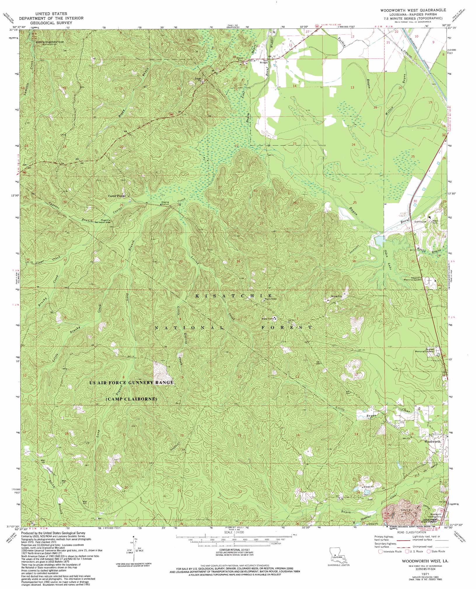
USGS Topo Quad 31092b5 - 1:24,000 scale
| Topo Map Name: | Woodworth West |
| USGS Topo Quad ID: | 31092b5 |
| Print Size: | ca. 21 1/4" wide x 27" high |
| Southeast Coordinates: | 31.125° N latitude / 92.5° W longitude |
| Map Center Coordinates: | 31.1875° N latitude / 92.5625° W longitude |
| U.S. State: | LA |
| Filename: | o31092b5.jpg |
| Download Map JPG Image: | Woodworth West topo map 1:24,000 scale |
| Map Type: | Topographic |
| Topo Series: | 7.5´ |
| Map Scale: | 1:24,000 |
| Source of Map Images: | United States Geological Survey (USGS) |
| Alternate Map Versions: |
Woodworth West LA 1971, updated 1973 Download PDF Buy paper map Woodworth West LA 1971, updated 1993 Download PDF Buy paper map Woodworth West LA 2003, updated 2005 Download PDF Buy paper map Woodworth West LA 2012 Download PDF Buy paper map Woodworth West LA 2015 Download PDF Buy paper map |
| FStopo: | US Forest Service topo Woodworth West is available: Download FStopo PDF Download FStopo TIF |
1:24,000 Topo Quads surrounding Woodworth West
Lena |
Boyce |
Rock Hill |
Ball |
Green Gables |
Jericho |
Gardner |
Rapides |
Alexandria |
Libuse |
Sieper |
Elmer |
Woodworth West |
Woodworth East |
Latanier |
Afeman |
Melder |
Forest Hill |
Lecompte |
Cheneyville |
Steep Gully |
Pawnee |
Glenmora |
Cocodrie Lake |
Lone Pine |
> Back to 31092a1 at 1:100,000 scale
> Back to 31092a1 at 1:250,000 scale
> Back to U.S. Topo Maps home
Woodworth West topo map: Gazetteer
Woodworth West: Airports
Woodworth Landing Strip elevation 47m 154′Woodworth West: Bridges
Twin Bridges elevation 22m 72′Woodworth West: Lakes
Oden Lake elevation 21m 68′Woodworth West: Parks
Castor Creek Scenic Area elevation 30m 98′Magnolia Recreation Park elevation 31m 101′
Woodworth West: Populated Places
Castor Plunge elevation 37m 121′Woodworth West: Streams
Bayou Hospital elevation 31m 101′Big Brushy Creek elevation 30m 98′
Boggu Bayou elevation 22m 72′
Castor Creek elevation 20m 65′
Clear Creek elevation 30m 98′
Cypress Branch elevation 25m 82′
Grassy Bayou elevation 22m 72′
Little Brushy Creek elevation 26m 85′
Little Creek elevation 27m 88′
Little Loving Creek elevation 27m 88′
Long Branch elevation 23m 75′
Lost Bayou elevation 20m 65′
Loving Creek elevation 22m 72′
Middle Bayou elevation 21m 68′
Woodworth West: Trails
Magnolia Forest Walk elevation 45m 147′Wild Azalea Trail elevation 50m 164′
Woodworth West digital topo map on disk
Buy this Woodworth West topo map showing relief, roads, GPS coordinates and other geographical features, as a high-resolution digital map file on DVD: