Buckeye Ne Topo Map Louisiana
To zoom in, hover over the map of Buckeye Ne
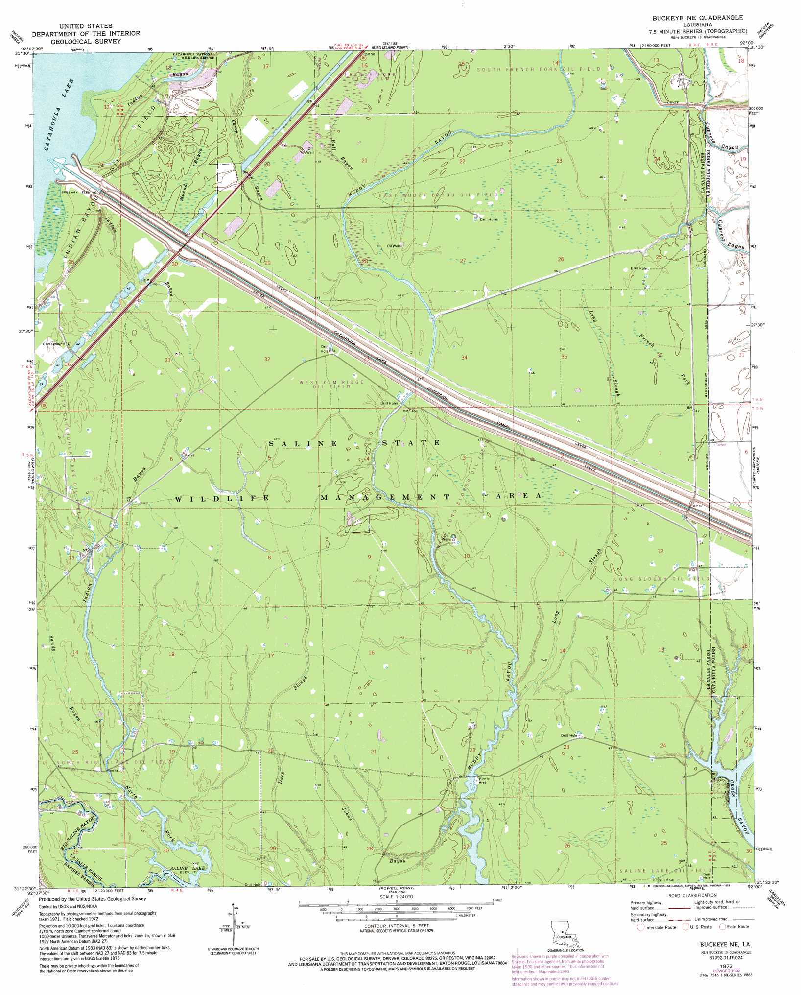
USGS Topo Quad 31092d1 - 1:24,000 scale
| Topo Map Name: | Buckeye Ne |
| USGS Topo Quad ID: | 31092d1 |
| Print Size: | ca. 21 1/4" wide x 27" high |
| Southeast Coordinates: | 31.375° N latitude / 92° W longitude |
| Map Center Coordinates: | 31.4375° N latitude / 92.0625° W longitude |
| U.S. State: | LA |
| Filename: | o31092d1.jpg |
| Download Map JPG Image: | Buckeye Ne topo map 1:24,000 scale |
| Map Type: | Topographic |
| Topo Series: | 7.5´ |
| Map Scale: | 1:24,000 |
| Source of Map Images: | United States Geological Survey (USGS) |
| Alternate Map Versions: |
Buckeye NE LA 1972, updated 1974 Download PDF Buy paper map Buckeye NE LA 1972, updated 1993 Download PDF Buy paper map Buckeye NE LA 1998, updated 2002 Download PDF Buy paper map Buckeye NE LA 2012 Download PDF Buy paper map Buckeye NE LA 2015 Download PDF Buy paper map |
1:24,000 Topo Quads surrounding Buckeye Ne
Little Creek |
Jena West |
Jena East |
Manifest |
Jonesville North |
Fishville |
Nebo |
Bird Island Point |
Walters |
Jonesville South |
Green Gables |
Holloway |
Buckeye Ne |
Larto Lake North |
Mayna |
Libuse |
Buckeye |
Powell Point |
Larto Lake South |
Acme |
Latanier |
Effie |
Marksville North |
Lac Sainte Agnes |
Ile Natchitoches |
> Back to 31092a1 at 1:100,000 scale
> Back to 31092a1 at 1:250,000 scale
> Back to U.S. Topo Maps home
Buckeye Ne topo map: Gazetteer
Buckeye Ne: Canals
Catahoula Lake Diversion Canal elevation 4m 13′Buckeye Ne: Guts
Duck Slough elevation 14m 45′French Fork elevation 15m 49′
Mound Bayou elevation 15m 49′
Buckeye Ne: Oilfields
Cypress Bayou Oil Field elevation 14m 45′East Muddy Bayou Oil Field elevation 15m 49′
French Fork Oil Field elevation 15m 49′
Indian Bayou Oil Field elevation 15m 49′
Long Slough Oil Field elevation 15m 49′
Muddy Bayou Oil Field elevation 14m 45′
North Big Island Oil Field elevation 12m 39′
Sandy Bayou Oil Field elevation 13m 42′
South Catahoula Lake Oil Field elevation 14m 45′
South Frence Fork Oil Field elevation 14m 45′
West Elm Ridge Oil Field elevation 14m 45′
West Long Slough Oil Field elevation 14m 45′
West Saline Lake Oil Field elevation 14m 45′
Buckeye Ne: Parks
Catahoula National Wildlife Refuge elevation 14m 45′Dewey W Wills State Wildlife Management Area elevation 13m 42′
Buckeye Ne: Streams
Bull Bayou elevation 13m 42′Cross Bayou elevation 11m 36′
Indian Bayou elevation 12m 39′
Johns Bayou elevation 11m 36′
Long Slough elevation 14m 45′
North Fork Big Saline Bayou elevation 12m 39′
Sandy Bayou elevation 12m 39′
Buckeye Ne digital topo map on disk
Buy this Buckeye Ne topo map showing relief, roads, GPS coordinates and other geographical features, as a high-resolution digital map file on DVD: