Lena Topo Map Louisiana
To zoom in, hover over the map of Lena
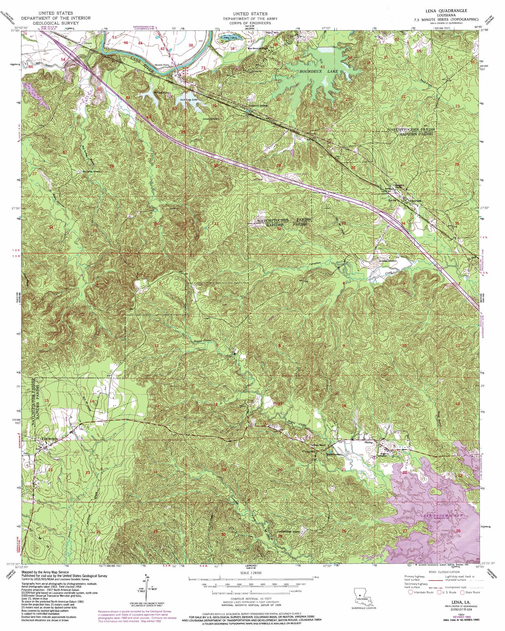
USGS Topo Quad 31092d7 - 1:24,000 scale
| Topo Map Name: | Lena |
| USGS Topo Quad ID: | 31092d7 |
| Print Size: | ca. 21 1/4" wide x 27" high |
| Southeast Coordinates: | 31.375° N latitude / 92.75° W longitude |
| Map Center Coordinates: | 31.4375° N latitude / 92.8125° W longitude |
| U.S. State: | LA |
| Filename: | o31092d7.jpg |
| Download Map JPG Image: | Lena topo map 1:24,000 scale |
| Map Type: | Topographic |
| Topo Series: | 7.5´ |
| Map Scale: | 1:24,000 |
| Source of Map Images: | United States Geological Survey (USGS) |
| Alternate Map Versions: |
Lena LA 1954, updated 1959 Download PDF Buy paper map Lena LA 1954, updated 1977 Download PDF Buy paper map Lena LA 1954, updated 1992 Download PDF Buy paper map Lena LA 2012 Download PDF Buy paper map Lena LA 2015 Download PDF Buy paper map |
1:24,000 Topo Quads surrounding Lena
Flora |
Montgomery |
Verda |
Savage Creek |
Williana |
Natchitoches South |
Cloutierville |
Aloha |
Colfax |
Dry Prong |
Bayou Livrogne |
Gorum |
Lena |
Boyce |
Rock Hill |
Simpson North |
Temple |
Jericho |
Gardner |
Rapides |
Simpson South |
Lacamp |
Sieper |
Elmer |
Woodworth West |
> Back to 31092a1 at 1:100,000 scale
> Back to 31092a1 at 1:250,000 scale
> Back to U.S. Topo Maps home
Lena topo map: Gazetteer
Lena: Dams
Boudreux Lake Dam elevation 29m 95′Lena: Lakes
Jack Luke Lake elevation 28m 91′Mitchell Lake elevation 29m 95′
Nash Lake elevation 26m 85′
Twin Lakes elevation 28m 91′
Lena: Oilfields
Galbraith Oil Field elevation 50m 164′Lena: Populated Places
Campbell elevation 48m 157′Chopin elevation 32m 104′
Flatwoods elevation 91m 298′
Galbraith elevation 49m 160′
Lena elevation 41m 134′
Sharp elevation 38m 124′
Lena: Post Offices
Chopin Post Office elevation 30m 98′Flatwoods Post Office elevation 85m 278′
Lena Post Office elevation 38m 124′
Lena: Reservoirs
Boudreaux Lake elevation 30m 98′Lena: Streams
Bay Spring Bayou elevation 24m 78′Bayou Castor elevation 31m 101′
Caney Branch elevation 23m 75′
Cherry Creek elevation 28m 91′
Horn Spring Branch elevation 32m 104′
Mill Bayou elevation 24m 78′
Odom Creek elevation 30m 98′
Lena: Summits
McAlpine Hill elevation 66m 216′Monnett Ferry Hill elevation 31m 101′
Lena: Swamps
Bird Lake elevation 27m 88′Oil Well Lake elevation 29m 95′
Lena digital topo map on disk
Buy this Lena topo map showing relief, roads, GPS coordinates and other geographical features, as a high-resolution digital map file on DVD: