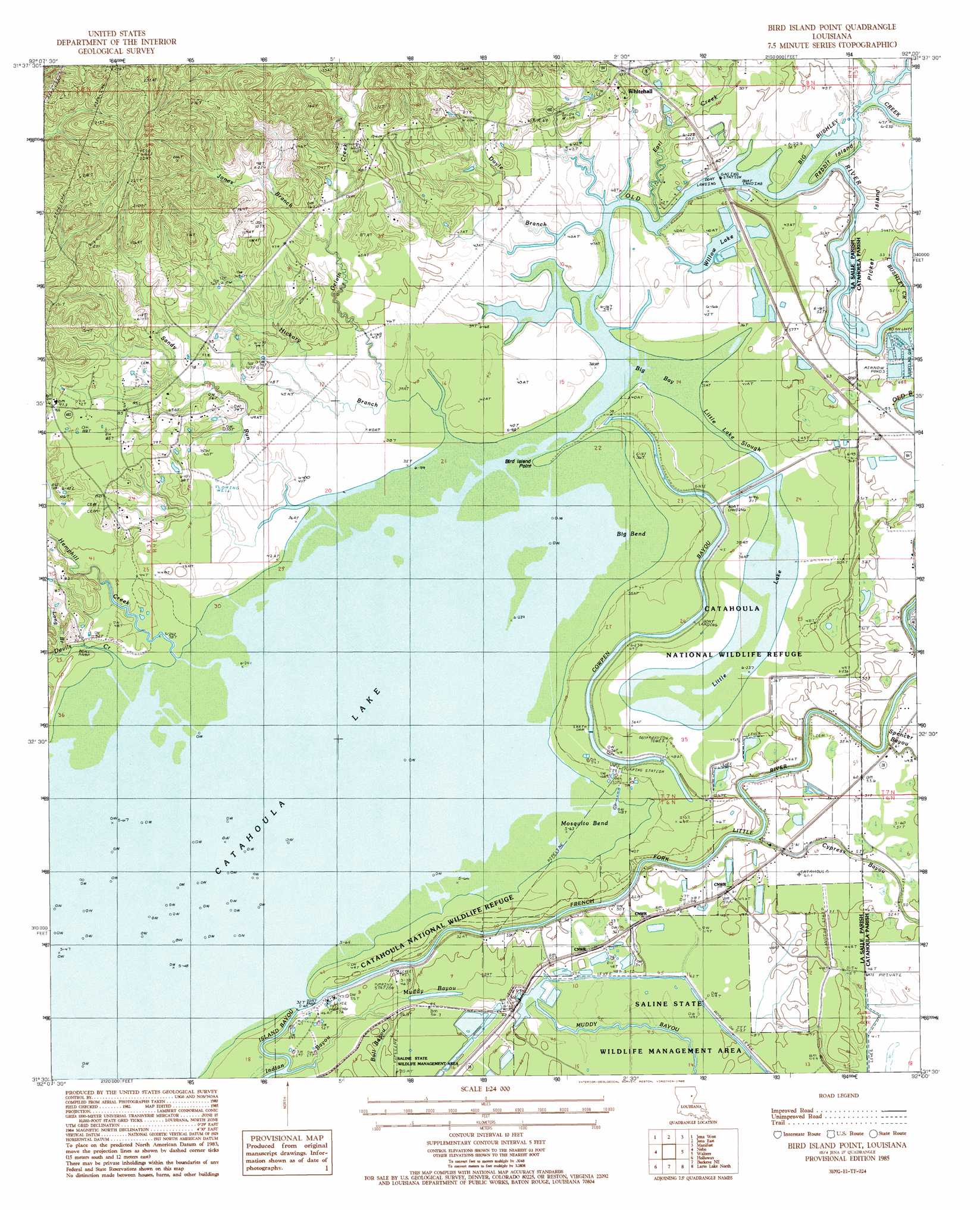
Bird Island Point Topo Map Louisiana
To zoom in, hover over the map of Bird Island Point
USGS Topo Quad 31092e1 - 1:24,000 scale
| Topo Map Name: | Bird Island Point |
| USGS Topo Quad ID: | 31092e1 |
| Print Size: | ca. 21 1/4" wide x 27" high |
| Southeast Coordinates: | 31.5° N latitude / 92° W longitude |
| Map Center Coordinates: | 31.5625° N latitude / 92.0625° W longitude |
| U.S. State: | LA |
| Filename: | o31092e1.jpg |
| Download Map JPG Image: | Bird Island Point topo map 1:24,000 scale |
| Map Type: | Topographic |
| Topo Series: | 7.5´ |
| Map Scale: | 1:24,000 |
| Source of Map Images: | United States Geological Survey (USGS) |
| Alternate Map Versions: |
Bird Island Point LA 1985, updated 1985 Download PDF Buy paper map Bird Island Point LA 1994, updated 1997 Download PDF Buy paper map Bird Island Point LA 2012 Download PDF Buy paper map Bird Island Point LA 2015 Download PDF Buy paper map |
1:24,000 Topo Quads surrounding Bird Island Point
Tullas |
Summerville |
Nickel |
Aimwell |
Harrisonburg |
Little Creek |
Jena West |
Jena East |
Manifest |
Jonesville North |
Fishville |
Nebo |
Bird Island Point |
Walters |
Jonesville South |
Green Gables |
Holloway |
Buckeye Ne |
Larto Lake North |
Mayna |
Libuse |
Buckeye |
Powell Point |
Larto Lake South |
Acme |
> Back to 31092e1 at 1:100,000 scale
> Back to 31092a1 at 1:250,000 scale
> Back to U.S. Topo Maps home
Bird Island Point topo map: Gazetteer
Bird Island Point: Bays
Big Bay elevation 12m 39′Bird Island Point: Bends
Big Bend elevation 9m 29′Mosquito Bend elevation 12m 39′
Bird Island Point: Capes
Bird Island Point elevation 12m 39′Bird Island Point: Crossings
Rhineharts Ferry (historical) elevation 9m 29′Bird Island Point: Guts
Little Lake Slough elevation 11m 36′Bird Island Point: Islands
Picket Island elevation 16m 52′Rabbit Island elevation 12m 39′
Bird Island Point: Lakes
Catahoula Lake elevation 9m 29′Little Lake elevation 11m 36′
Willow Lake elevation 11m 36′
Bird Island Point: Oilfields
Catahoula Lake Oil Field elevation 9m 29′East Nebo Oil Field elevation 28m 91′
French Fork Oil Field elevation 13m 42′
Mosquito Bend Oil Field elevation 12m 39′
Bird Island Point: Populated Places
Sharp Town elevation 25m 82′Whitehall elevation 27m 88′
Bird Island Point: Streams
Big Bushley Creek elevation 9m 29′Browns Branch elevation 10m 32′
Buck Holly Branch elevation 18m 59′
Camp Bayou elevation 11m 36′
Cowpen Bayou elevation 9m 29′
Devils Creek elevation 10m 32′
Doyle Branch elevation 10m 32′
Earl Creek elevation 11m 36′
Gelvin Creek elevation 12m 39′
Hemphill Creek elevation 10m 32′
Hickory Branch elevation 12m 39′
Island Bayou elevation 10m 32′
Jones Branch elevation 18m 59′
Little Bushley Creek elevation 11m 36′
Long Branch elevation 11m 36′
Sandy Run elevation 12m 39′
Bird Island Point digital topo map on disk
Buy this Bird Island Point topo map showing relief, roads, GPS coordinates and other geographical features, as a high-resolution digital map file on DVD: