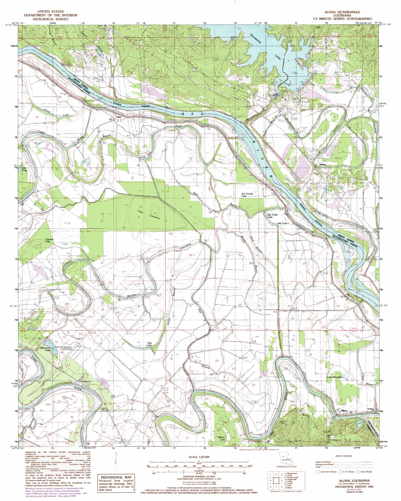
Aloha Topo Map Louisiana
To zoom in, hover over the map of Aloha
USGS Topo Quad 31092e7 - 1:24,000 scale
| Topo Map Name: | Aloha |
| USGS Topo Quad ID: | 31092e7 |
| Print Size: | ca. 21 1/4" wide x 27" high |
| Southeast Coordinates: | 31.5° N latitude / 92.75° W longitude |
| Map Center Coordinates: | 31.5625° N latitude / 92.8125° W longitude |
| U.S. State: | LA |
| Filename: | o31092e7.jpg |
| Download Map JPG Image: | Aloha topo map 1:24,000 scale |
| Map Type: | Topographic |
| Topo Series: | 7.5´ |
| Map Scale: | 1:24,000 |
| Source of Map Images: | United States Geological Survey (USGS) |
| Alternate Map Versions: |
Aloha LA 1983, updated 1984 Download PDF Buy paper map Aloha LA 1983, updated 1992 Download PDF Buy paper map Aloha LA 2012 Download PDF Buy paper map Aloha LA 2015 Download PDF Buy paper map |
1:24,000 Topo Quads surrounding Aloha
Natchitoches North |
Saint Maurice |
Coochie Brake |
Atlanta |
Packton |
Flora |
Montgomery |
Verda |
Savage Creek |
Williana |
Natchitoches South |
Cloutierville |
Aloha |
Colfax |
Dry Prong |
Bayou Livrogne |
Gorum |
Lena |
Boyce |
Rock Hill |
Simpson North |
Temple |
Jericho |
Gardner |
Rapides |
> Back to 31092e1 at 1:100,000 scale
> Back to 31092a1 at 1:250,000 scale
> Back to U.S. Topo Maps home
Aloha topo map: Gazetteer
Aloha: Airports
Little Eva Plantation Landing Strip elevation 30m 98′Aloha: Bends
Ash Brake Bottom elevation 28m 91′Aloha: Canals
Marco Canal elevation 26m 85′Aloha: Cliffs
Waddel Bluff elevation 28m 91′Aloha: Dams
Louisiana Noname 83 Dam elevation 32m 104′Nantachie Lake Dam elevation 29m 95′
Aloha: Guts
Bayou Cocodrie elevation 29m 95′Bayou Grappe elevation 27m 88′
Bayou Nid Aigle elevation 30m 98′
Boggy Bayou elevation 30m 98′
Boggy Bayou elevation 28m 91′
Corfeine Bayou elevation 27m 88′
Flat Bayou elevation 29m 95′
Horse Bayou elevation 27m 88′
Jack Bayou elevation 29m 95′
Red Bayou elevation 29m 95′
Aloha: Lakes
Big Trudo Lake elevation 26m 85′Chico Lake elevation 27m 88′
Chicot Lake (historical) elevation 27m 88′
Cow Lake elevation 28m 91′
Flag Lake elevation 28m 91′
Lake Morantine elevation 27m 88′
Lake Rond elevation 29m 95′
Little Trudo Lake elevation 29m 95′
Round Lake (historical) elevation 28m 91′
Walker Lake elevation 28m 91′
Willow Lake elevation 27m 88′
Aloha: Oilfields
Aloha Oil Field elevation 29m 95′Aloha: Populated Places
Aloha elevation 30m 98′Billis (historical) elevation 47m 154′
Marco elevation 30m 98′
Odra elevation 29m 95′
Waddel elevation 29m 95′
Aloha: Streams
Bayou Barbue elevation 28m 91′Falcon Bayou elevation 30m 98′
Little River elevation 28m 91′
Nantachie Creek elevation 28m 91′
Tyrouge Bayou elevation 28m 91′
Aloha: Swamps
Blanchard Lake elevation 27m 88′Calf Lake elevation 28m 91′
Chicot Lake elevation 28m 91′
Cypress Lake elevation 29m 95′
Hog Lake elevation 28m 91′
Jim Young Lake elevation 29m 95′
Lake Cocodrie elevation 27m 88′
Lake Morgantine elevation 28m 91′
Moreau Lake elevation 27m 88′
Ross Lake elevation 27m 88′
Round Lake elevation 27m 88′
Tiger Lake elevation 27m 88′
Aloha digital topo map on disk
Buy this Aloha topo map showing relief, roads, GPS coordinates and other geographical features, as a high-resolution digital map file on DVD: