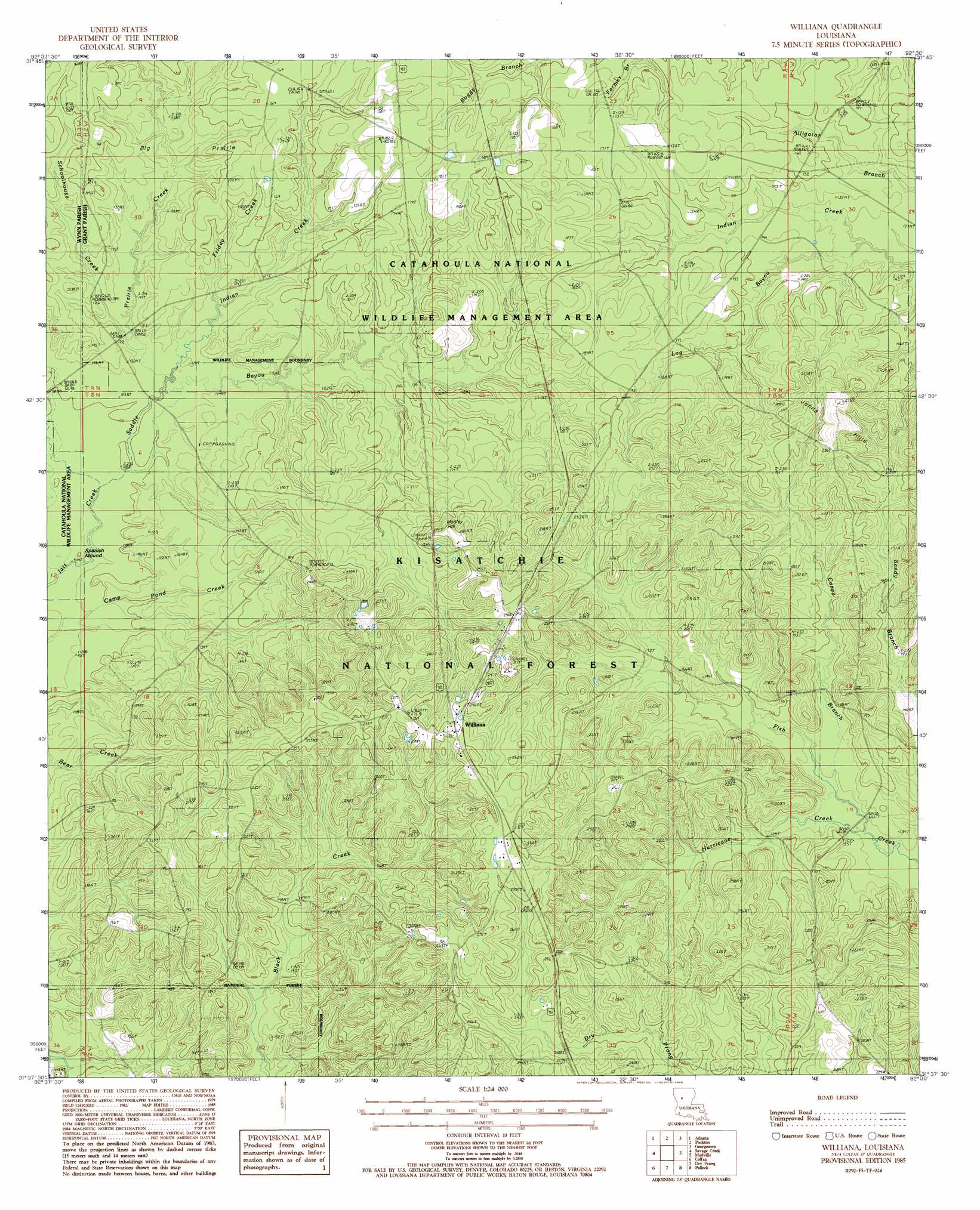
Williana Topo Map Louisiana
To zoom in, hover over the map of Williana
USGS Topo Quad 31092f5 - 1:24,000 scale
| Topo Map Name: | Williana |
| USGS Topo Quad ID: | 31092f5 |
| Print Size: | ca. 21 1/4" wide x 27" high |
| Southeast Coordinates: | 31.625° N latitude / 92.5° W longitude |
| Map Center Coordinates: | 31.6875° N latitude / 92.5625° W longitude |
| U.S. State: | LA |
| Filename: | o31092f5.jpg |
| Download Map JPG Image: | Williana topo map 1:24,000 scale |
| Map Type: | Topographic |
| Topo Series: | 7.5´ |
| Map Scale: | 1:24,000 |
| Source of Map Images: | United States Geological Survey (USGS) |
| Alternate Map Versions: |
Williana LA 1985, updated 1985 Download PDF Buy paper map Williana LA 2003, updated 2005 Download PDF Buy paper map Williana LA 2012 Download PDF Buy paper map Williana LA 2015 Download PDF Buy paper map |
| FStopo: | US Forest Service topo Williana is available: Download FStopo PDF Download FStopo TIF |
1:24,000 Topo Quads surrounding Williana
Calvin |
Winnfield West |
Winnfield East |
Flat Creek |
Fords Creek |
Coochie Brake |
Atlanta |
Packton |
Georgetown |
Tullas |
Verda |
Savage Creek |
Williana |
Mudville |
Little Creek |
Aloha |
Colfax |
Dry Prong |
Pollock |
Fishville |
Lena |
Boyce |
Rock Hill |
Ball |
Green Gables |
> Back to 31092e1 at 1:100,000 scale
> Back to 31092a1 at 1:250,000 scale
> Back to U.S. Topo Maps home
Williana topo map: Gazetteer
Williana: Flats
Big Prairie elevation 39m 127′Williana: Parks
Catahoula National Wildlife Management Area elevation 52m 170′Williana: Populated Places
Black Creek (historical) elevation 63m 206′Lutes elevation 76m 249′
Tide (historical) elevation 45m 147′
Williana elevation 77m 252′
Williana: Streams
Caney Branch elevation 38m 124′Double Branches elevation 39m 127′
Friday Creek elevation 32m 104′
Hurricane Creek elevation 37m 121′
Indian Creek elevation 32m 104′
Log Bayou elevation 37m 121′
Prairie Creek elevation 32m 104′
Saddle Bayou elevation 29m 95′
Schoolhouse Creek elevation 32m 104′
Williana: Summits
Mosley Hill elevation 65m 213′Spanish Mound elevation 31m 101′
Williana digital topo map on disk
Buy this Williana topo map showing relief, roads, GPS coordinates and other geographical features, as a high-resolution digital map file on DVD: