Savage Creek Topo Map Louisiana
To zoom in, hover over the map of Savage Creek
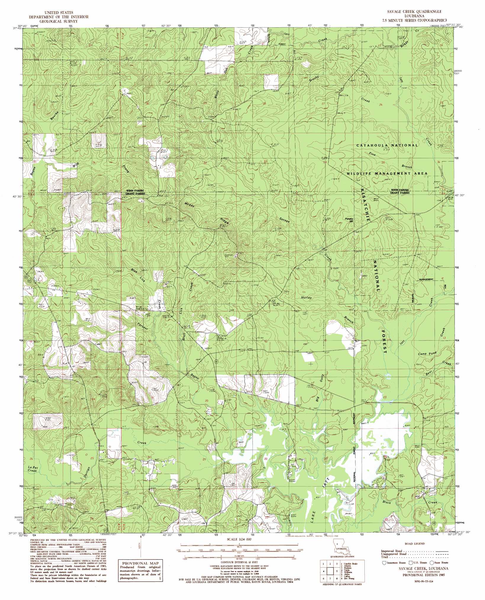
USGS Topo Quad 31092f6 - 1:24,000 scale
| Topo Map Name: | Savage Creek |
| USGS Topo Quad ID: | 31092f6 |
| Print Size: | ca. 21 1/4" wide x 27" high |
| Southeast Coordinates: | 31.625° N latitude / 92.625° W longitude |
| Map Center Coordinates: | 31.6875° N latitude / 92.6875° W longitude |
| U.S. State: | LA |
| Filename: | o31092f6.jpg |
| Download Map JPG Image: | Savage Creek topo map 1:24,000 scale |
| Map Type: | Topographic |
| Topo Series: | 7.5´ |
| Map Scale: | 1:24,000 |
| Source of Map Images: | United States Geological Survey (USGS) |
| Alternate Map Versions: |
Savage Creek LA 1985, updated 1985 Download PDF Buy paper map Savage Creek LA 2003, updated 2005 Download PDF Buy paper map Savage Creek LA 2012 Download PDF Buy paper map Savage Creek LA 2015 Download PDF Buy paper map |
| FStopo: | US Forest Service topo Savage Creek is available: Download FStopo PDF Download FStopo TIF |
1:24,000 Topo Quads surrounding Savage Creek
Coup Point |
Calvin |
Winnfield West |
Winnfield East |
Flat Creek |
Saint Maurice |
Coochie Brake |
Atlanta |
Packton |
Georgetown |
Montgomery |
Verda |
Savage Creek |
Williana |
Mudville |
Cloutierville |
Aloha |
Colfax |
Dry Prong |
Pollock |
Gorum |
Lena |
Boyce |
Rock Hill |
Ball |
> Back to 31092e1 at 1:100,000 scale
> Back to 31092a1 at 1:250,000 scale
> Back to U.S. Topo Maps home
Savage Creek topo map: Gazetteer
Savage Creek: Forests
The Big Woods elevation 43m 141′Savage Creek: Oilfields
Blue Lick Creek Oil Field elevation 51m 167′White Oak Creek Oil Field elevation 70m 229′
Savage Creek: Populated Places
Iatt elevation 57m 187′Savage Creek: Ridges
Mossy Ridge elevation 62m 203′Savage Creek: Streams
Bear Creek elevation 26m 85′Black Creek elevation 26m 85′
Blue Lick Creek elevation 40m 131′
Bluff Lick Creek elevation 31m 101′
Boggy Creek elevation 33m 108′
Brushy Creek elevation 34m 111′
Camp Pond Creek elevation 26m 85′
Dartigo Creek elevation 26m 85′
Hurley Branch elevation 31m 101′
Iatt Creek elevation 25m 82′
LaPet Creek elevation 32m 104′
Parasol Bayou elevation 26m 85′
Pine Branch elevation 32m 104′
Savage Creek elevation 27m 88′
White Oak Creek elevation 40m 131′
Wild Prong elevation 48m 157′
Savage Creek: Summits
Potato Hill elevation 54m 177′Savage Creek: Valleys
Big Gully elevation 26m 85′Savage Creek digital topo map on disk
Buy this Savage Creek topo map showing relief, roads, GPS coordinates and other geographical features, as a high-resolution digital map file on DVD: