Wiergate Topo Map Texas
To zoom in, hover over the map of Wiergate
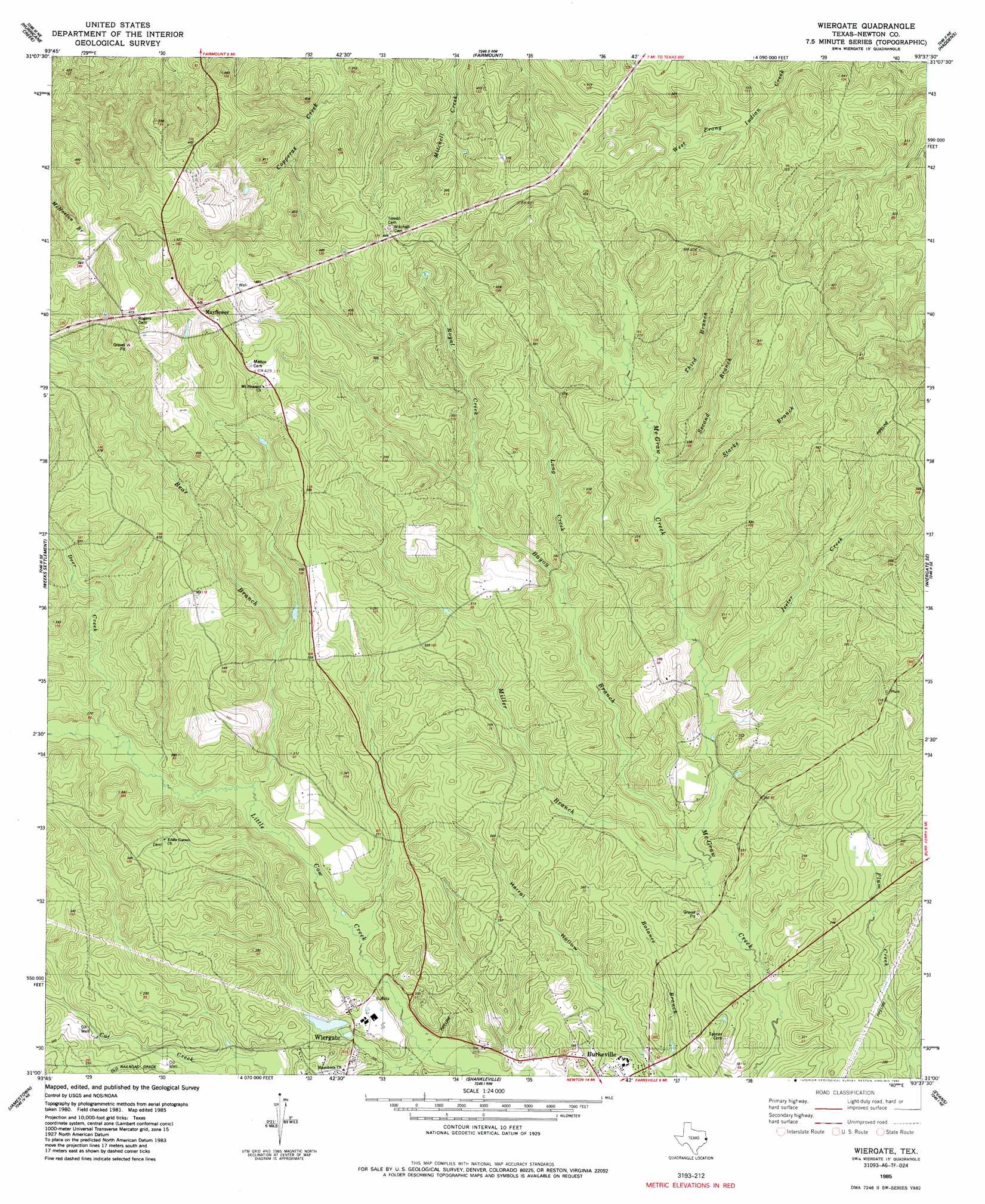
USGS Topo Quad 31093a6 - 1:24,000 scale
| Topo Map Name: | Wiergate |
| USGS Topo Quad ID: | 31093a6 |
| Print Size: | ca. 21 1/4" wide x 27" high |
| Southeast Coordinates: | 31° N latitude / 93.625° W longitude |
| Map Center Coordinates: | 31.0625° N latitude / 93.6875° W longitude |
| U.S. State: | TX |
| Filename: | o31093a6.jpg |
| Download Map JPG Image: | Wiergate topo map 1:24,000 scale |
| Map Type: | Topographic |
| Topo Series: | 7.5´ |
| Map Scale: | 1:24,000 |
| Source of Map Images: | United States Geological Survey (USGS) |
| Alternate Map Versions: |
Wiergate TX 1954, updated 1958 Download PDF Buy paper map Wiergate TX 1954, updated 1976 Download PDF Buy paper map Wiergate TX 1985, updated 1985 Download PDF Buy paper map Wiergate TX 2010 Download PDF Buy paper map Wiergate TX 2012 Download PDF Buy paper map Wiergate TX 2016 Download PDF Buy paper map |
1:24,000 Topo Quads surrounding Wiergate
Pineland North |
Hemphill |
Negreet Sw |
Toro |
Hornbeck |
Pineland South |
Hurricane Creek |
Fairmount |
Haddens |
Little Sandy Creek |
Harrisburg |
Weeks Settlement |
Wiergate |
Wiergate Se |
Burr Ferry |
Jasper East |
Jamestown |
Shankleville |
Evans |
Knight |
Roganville |
Newton West |
Newton East |
Merryville North |
Neale |
> Back to 31093a1 at 1:100,000 scale
> Back to 31092a1 at 1:250,000 scale
> Back to U.S. Topo Maps home
Wiergate topo map: Gazetteer
Wiergate: Dams
Smith Lake Dam elevation 63m 206′Wiergate: Populated Places
Mayflower elevation 132m 433′Wiergate: Reservoirs
Smith Lake elevation 63m 206′Wiergate: Streams
Bayou Branch elevation 52m 170′Bear Branch elevation 65m 213′
Deer Creek elevation 72m 236′
Jeeter Creek elevation 61m 200′
Long Creek elevation 69m 226′
Miller Branch elevation 52m 170′
Royal Creek elevation 69m 226′
Second Branch McGraw Creek elevation 70m 229′
Starks Branch elevation 68m 223′
Third Branch McGraw Creek elevation 74m 242′
Wiergate digital topo map on disk
Buy this Wiergate topo map showing relief, roads, GPS coordinates and other geographical features, as a high-resolution digital map file on DVD: