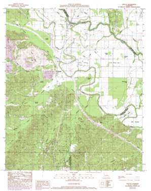
Evelyn Topo Map Louisiana
To zoom in, hover over the map of Evelyn
USGS Topo Quad 31093h4 - 1:24,000 scale
| Topo Map Name: | Evelyn |
| USGS Topo Quad ID: | 31093h4 |
| Print Size: | ca. 21 1/4" wide x 27" high |
| Southeast Coordinates: | 31.875° N latitude / 93.375° W longitude |
| Map Center Coordinates: | 31.9375° N latitude / 93.4375° W longitude |
| U.S. State: | LA |
| Filename: | o31093h4.jpg |
| Download Map JPG Image: | Evelyn topo map 1:24,000 scale |
| Map Type: | Topographic |
| Topo Series: | 7.5´ |
| Map Scale: | 1:24,000 |
| Source of Map Images: | United States Geological Survey (USGS) |
| Alternate Map Versions: |
Evelyn LA 1989, updated 1989 Download PDF Buy paper map Evelyn LA 1989, updated 1992 Download PDF Buy paper map Evelyn LA 2012 Download PDF Buy paper map Evelyn LA 2015 Download PDF Buy paper map |
1:24,000 Topo Quads surrounding Evelyn
> Back to 31093e1 at 1:100,000 scale
> Back to 31092a1 at 1:250,000 scale
> Back to U.S. Topo Maps home
Evelyn topo map: Gazetteer
Evelyn: Bridges
Mary Cox Bridge elevation 38m 124′Evelyn: Capes
Buck Neck elevation 39m 127′Evelyn: Guts
Bois d'arc Bayou elevation 40m 131′Evelyn: Lakes
Long Lake (historical) elevation 38m 124′Teloque Lake elevation 37m 121′
Thorny Lake (historical) elevation 38m 124′
Evelyn: Oilfields
Chemard Lake Oil Field elevation 39m 127′Grogan Oil Field elevation 49m 160′
Evelyn: Populated Places
Ajax elevation 73m 239′Butler (historical) elevation 47m 154′
Evelyn elevation 40m 131′
Harris elevation 67m 219′
Pleasant Hill elevation 38m 124′
Rambin elevation 47m 154′
Wallace elevation 69m 226′
Evelyn: Streams
Belle Bayou elevation 44m 144′Blanchard Bayou elevation 42m 137′
Dead Negro Branch elevation 37m 121′
Dolet Bayou elevation 36m 118′
Flat River elevation 39m 127′
Hickman Bayou elevation 37m 121′
Jims River elevation 37m 121′
Little Flat River elevation 38m 124′
Little Wallace Bayou elevation 37m 121′
Louies Bayou elevation 37m 121′
Maguire Branch elevation 33m 108′
Pigpen Bayou elevation 31m 101′
Prairie Bayou elevation 37m 121′
Rambin Bayou elevation 38m 124′
Shell Bayou elevation 31m 101′
Thompson Creek elevation 37m 121′
Wallace Bayou elevation 38m 124′
West Branch Dolet Bayou elevation 38m 124′
Evelyn: Swamps
Campti Lake (historical) elevation 39m 127′Chemard Lake elevation 41m 134′
Couchanda Lake (historical) elevation 40m 131′
Dolet Brake elevation 38m 124′
Grassy Lake elevation 39m 127′
Little Grassy Lake elevation 39m 127′
Louies Brake elevation 38m 124′
Sample Brake elevation 39m 127′
Stumpy Lake elevation 38m 124′
Watermelon Lake elevation 37m 121′
Evelyn digital topo map on disk
Buy this Evelyn topo map showing relief, roads, GPS coordinates and other geographical features, as a high-resolution digital map file on DVD:


