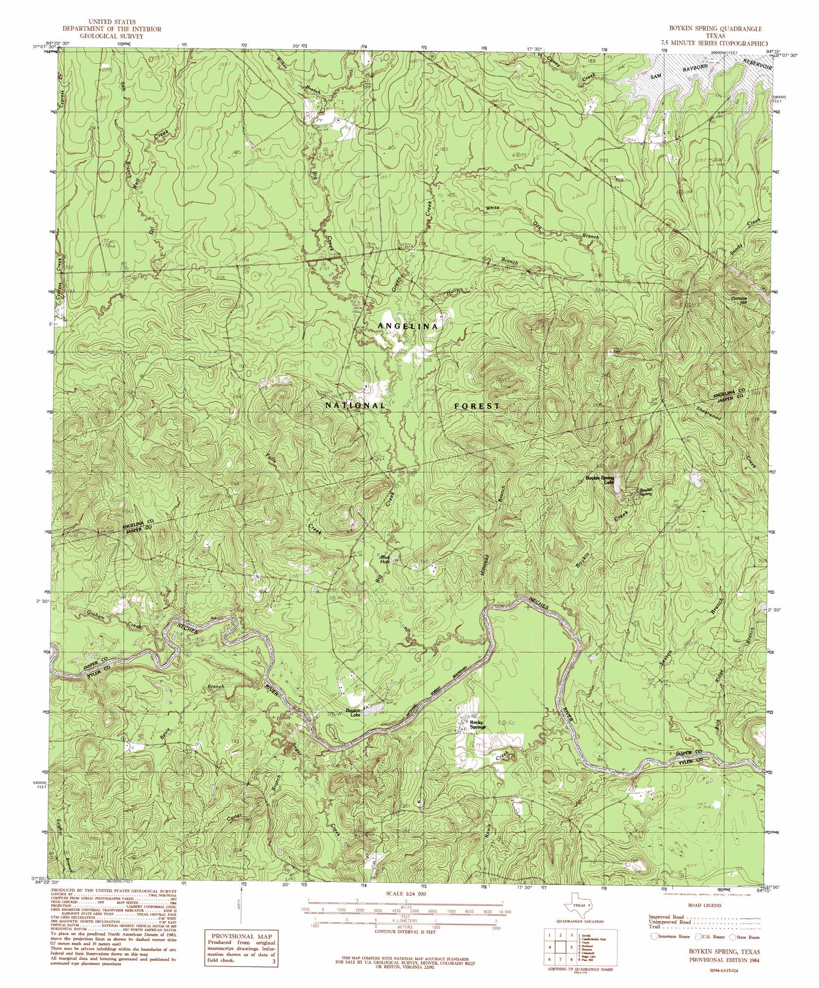
Boykin Spring Topo Map Texas
To zoom in, hover over the map of Boykin Spring
USGS Topo Quad 31094a3 - 1:24,000 scale
| Topo Map Name: | Boykin Spring |
| USGS Topo Quad ID: | 31094a3 |
| Print Size: | ca. 21 1/4" wide x 27" high |
| Southeast Coordinates: | 31° N latitude / 94.25° W longitude |
| Map Center Coordinates: | 31.0625° N latitude / 94.3125° W longitude |
| U.S. State: | TX |
| Filename: | o31094a3.jpg |
| Download Map JPG Image: | Boykin Spring topo map 1:24,000 scale |
| Map Type: | Topographic |
| Topo Series: | 7.5´ |
| Map Scale: | 1:24,000 |
| Source of Map Images: | United States Geological Survey (USGS) |
| Alternate Map Versions: |
Boykin Spring TX 1984, updated 1984 Download PDF Buy paper map Boykin Spring TX 1984, updated 1984 Download PDF Buy paper map Boykin Spring TX 2010 Download PDF Buy paper map Boykin Spring TX 2013 Download PDF Buy paper map Boykin Spring TX 2016 Download PDF Buy paper map |
| FStopo: | US Forest Service topo Boykin Spring is available: Download FStopo PDF Download FStopo TIF |
1:24,000 Topo Quads surrounding Boykin Spring
Huntington |
Etoile South |
Broaddus |
Harvey Creek |
Bronson |
Manning |
Zavalla |
Cassells-Boykin Park |
Veach |
Buck Bay |
Wolf Hill |
Rockland |
Boykin Spring |
Ebenezer |
Mcgee Bend |
Chester |
Colmesneil |
Boggy Lake |
Pace Hill |
Jasper West |
Chambliss Hill |
Woodville |
Birdwell Lake |
Town Bluff |
Beech Grove |
> Back to 31094a1 at 1:100,000 scale
> Back to 31094a1 at 1:250,000 scale
> Back to U.S. Topo Maps home
Boykin Spring topo map: Gazetteer
Boykin Spring: Bays
Blue Hole elevation 35m 114′Boykin Spring: Dams
Boykin Lake Dam elevation 43m 141′Boykin Spring: Lakes
Bouton Lake elevation 32m 104′Boykin Spring Lake elevation 47m 154′
Boykin Spring: Populated Places
Concord elevation 50m 164′Boykin Spring: Reservoirs
Boykin Lake elevation 43m 141′Boykin Spring: Springs
Boykin Spring elevation 45m 147′Rocky Springs elevation 43m 141′
Boykin Spring: Streams
Beale Branch elevation 28m 91′Big Creek elevation 27m 88′
Boykin Creek elevation 28m 91′
Caney Creek elevation 51m 167′
Carter Branch elevation 34m 111′
Falls Creek elevation 33m 108′
Graham Creek elevation 35m 114′
Green Creek elevation 38m 124′
Holly Branch elevation 40m 131′
Millstead Branch elevation 26m 85′
Pole Ridge Branch elevation 26m 85′
Rawls Creek elevation 26m 85′
Salt Branch elevation 53m 173′
Sexton Branch elevation 27m 88′
Sugar Creek elevation 30m 98′
White Oak Branch elevation 49m 160′
Wilkes Branch elevation 50m 164′
Boykin Spring: Summits
Cyclone Hill elevation 120m 393′Boykin Spring: Trails
Sawmill Hiking Trail elevation 35m 114′Boykin Spring digital topo map on disk
Buy this Boykin Spring topo map showing relief, roads, GPS coordinates and other geographical features, as a high-resolution digital map file on DVD: