Wolf Hill Topo Map Texas
To zoom in, hover over the map of Wolf Hill
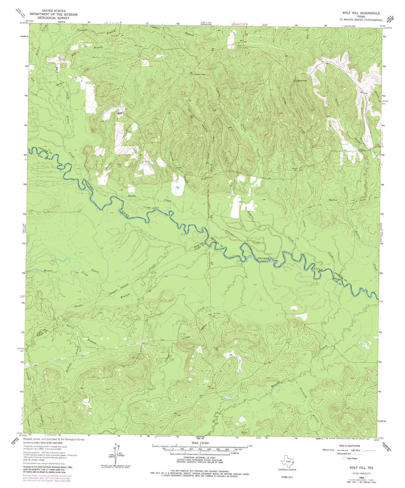
USGS Topo Quad 31094a5 - 1:24,000 scale
| Topo Map Name: | Wolf Hill |
| USGS Topo Quad ID: | 31094a5 |
| Print Size: | ca. 21 1/4" wide x 27" high |
| Southeast Coordinates: | 31° N latitude / 94.5° W longitude |
| Map Center Coordinates: | 31.0625° N latitude / 94.5625° W longitude |
| U.S. State: | TX |
| Filename: | o31094a5.jpg |
| Download Map JPG Image: | Wolf Hill topo map 1:24,000 scale |
| Map Type: | Topographic |
| Topo Series: | 7.5´ |
| Map Scale: | 1:24,000 |
| Source of Map Images: | United States Geological Survey (USGS) |
| Alternate Map Versions: |
Lufkin 4-d TX 1928 Download PDF Buy paper map Wolf Hill TX 1963, updated 1966 Download PDF Buy paper map Wolf Hill TX 1963, updated 1980 Download PDF Buy paper map Wolf Hill TX 2010 Download PDF Buy paper map Wolf Hill TX 2013 Download PDF Buy paper map Wolf Hill TX 2016 Download PDF Buy paper map |
1:24,000 Topo Quads surrounding Wolf Hill
Keltys |
Lufkin |
Huntington |
Etoile South |
Broaddus |
Diboll |
Bald Hill |
Manning |
Zavalla |
Cassells-Boykin Park |
Wakefield |
Pluck |
Wolf Hill |
Rockland |
Boykin Spring |
Corrigan |
Camden |
Chester |
Colmesneil |
Boggy Lake |
Leggett |
Hortense |
Chambliss Hill |
Woodville |
Birdwell Lake |
> Back to 31094a1 at 1:100,000 scale
> Back to 31094a1 at 1:250,000 scale
> Back to U.S. Topo Maps home
Wolf Hill topo map: Gazetteer
Wolf Hill: Streams
Banks Creek elevation 37m 121′Big Branch elevation 40m 131′
Biloxi Creek elevation 37m 121′
Buck Creek elevation 39m 127′
Buck Creek elevation 37m 121′
Burris Creek elevation 34m 111′
Caney Creek elevation 33m 108′
Clear Creek elevation 34m 111′
Dry Creek elevation 38m 124′
Fourmile Branch elevation 40m 131′
Gin Creek elevation 37m 121′
Howell Creek elevation 38m 124′
Johnson Creek elevation 35m 114′
Loggins Creek elevation 34m 111′
McDuffy Branch elevation 42m 137′
Piney Creek elevation 33m 108′
Powell Branch elevation 36m 118′
Powell Branch elevation 36m 118′
Saline Branch elevation 39m 127′
Sandy Branch elevation 33m 108′
Wolf Hill: Summits
Wolf Hill elevation 111m 364′Wolf Hill digital topo map on disk
Buy this Wolf Hill topo map showing relief, roads, GPS coordinates and other geographical features, as a high-resolution digital map file on DVD: