Buck Bay Topo Map Texas
To zoom in, hover over the map of Buck Bay
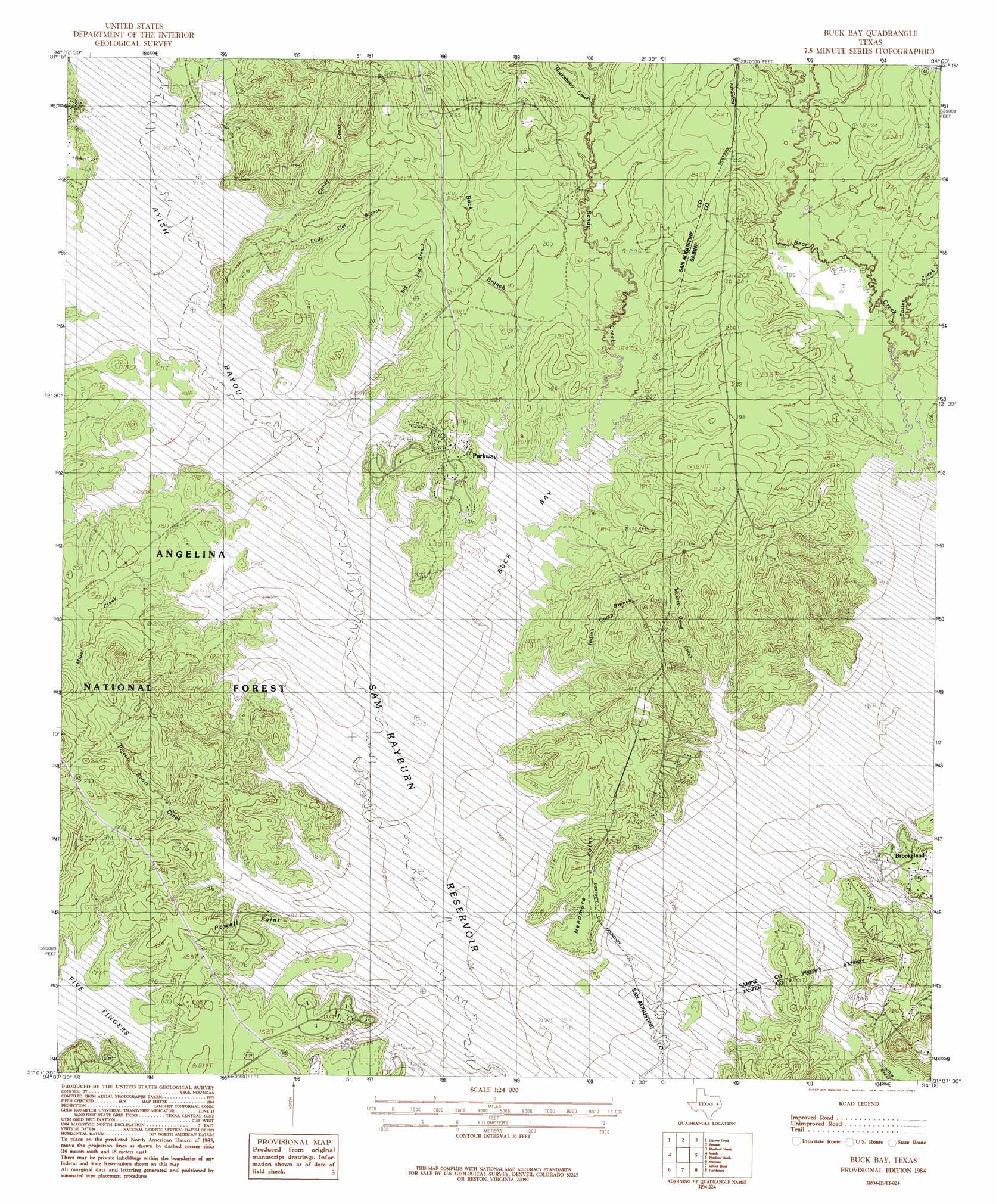
USGS Topo Quad 31094b1 - 1:24,000 scale
| Topo Map Name: | Buck Bay |
| USGS Topo Quad ID: | 31094b1 |
| Print Size: | ca. 21 1/4" wide x 27" high |
| Southeast Coordinates: | 31.125° N latitude / 94° W longitude |
| Map Center Coordinates: | 31.1875° N latitude / 94.0625° W longitude |
| U.S. State: | TX |
| Filename: | o31094b1.jpg |
| Download Map JPG Image: | Buck Bay topo map 1:24,000 scale |
| Map Type: | Topographic |
| Topo Series: | 7.5´ |
| Map Scale: | 1:24,000 |
| Source of Map Images: | United States Geological Survey (USGS) |
| Alternate Map Versions: |
Buck Bay TX 1984, updated 1984 Download PDF Buy paper map Buck Bay TX 2003, updated 2004 Download PDF Buy paper map Buck Bay TX 2010 Download PDF Buy paper map Buck Bay TX 2013 Download PDF Buy paper map Buck Bay TX 2016 Download PDF Buy paper map |
| FStopo: | US Forest Service topo Buck Bay is available: Download FStopo PDF Download FStopo TIF |
1:24,000 Topo Quads surrounding Buck Bay
Chireno South |
Norwood |
Chinquapin |
Geneva |
Milam |
Broaddus |
Harvey Creek |
Bronson |
Pineland North |
Hemphill |
Cassells-Boykin Park |
Veach |
Buck Bay |
Pineland South |
Hurricane Creek |
Boykin Spring |
Ebenezer |
Mcgee Bend |
Harrisburg |
Weeks Settlement |
Boggy Lake |
Pace Hill |
Jasper West |
Jasper East |
Jamestown |
> Back to 31094a1 at 1:100,000 scale
> Back to 31094a1 at 1:250,000 scale
> Back to U.S. Topo Maps home
Buck Bay topo map: Gazetteer
Buck Bay: Bays
Buck Bay elevation 50m 164′Buck Bay: Capes
Needmore Point elevation 58m 190′Powell Point elevation 59m 193′
Buck Bay: Parks
Mills Creek Park elevation 50m 164′San Augustine Park elevation 50m 164′
Buck Bay: Populated Places
Needmore elevation 50m 164′Parkway elevation 58m 190′
Buck Bay: Streams
Ayish Bayou elevation 50m 164′Big Flat Branch elevation 50m 164′
Boggy Branch elevation 50m 164′
Boggy Branch elevation 50m 164′
Briar Branch elevation 50m 164′
Buck Branch elevation 50m 164′
Caney Creek elevation 50m 164′
Couchatana Creek elevation 50m 164′
Easley Creek elevation 51m 167′
Huckleberry Creek elevation 64m 209′
Indian Camp Branch elevation 50m 164′
Lane Creek elevation 50m 164′
Little Creek elevation 50m 164′
Little Flat Branch elevation 50m 164′
Massey-Good Branch elevation 50m 164′
McKim Creek elevation 50m 164′
Mill Creek elevation 50m 164′
Miller Creek elevation 50m 164′
Owl Creek elevation 50m 164′
Pigeon Roost Creek elevation 50m 164′
Pomponaugh Creek elevation 50m 164′
Sandy Creek elevation 50m 164′
Trout Bayou elevation 50m 164′
Buck Bay digital topo map on disk
Buy this Buck Bay topo map showing relief, roads, GPS coordinates and other geographical features, as a high-resolution digital map file on DVD: