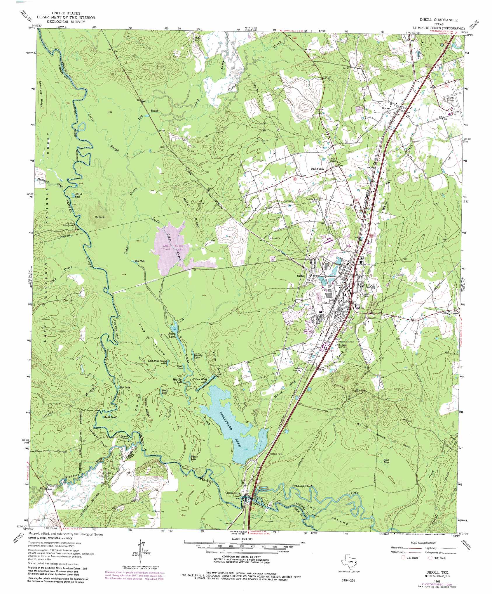
Diboll Topo Map Texas
To zoom in, hover over the map of Diboll
USGS Topo Quad 31094b7 - 1:24,000 scale
| Topo Map Name: | Diboll |
| USGS Topo Quad ID: | 31094b7 |
| Print Size: | ca. 21 1/4" wide x 27" high |
| Southeast Coordinates: | 31.125° N latitude / 94.75° W longitude |
| Map Center Coordinates: | 31.1875° N latitude / 94.8125° W longitude |
| U.S. State: | TX |
| Filename: | o31094b7.jpg |
| Download Map JPG Image: | Diboll topo map 1:24,000 scale |
| Map Type: | Topographic |
| Topo Series: | 7.5´ |
| Map Scale: | 1:24,000 |
| Source of Map Images: | United States Geological Survey (USGS) |
| Alternate Map Versions: |
Diboll TX 1963, updated 1966 Download PDF Buy paper map Diboll TX 1963, updated 1980 Download PDF Buy paper map Diboll TX 2004, updated 2006 Download PDF Buy paper map Diboll TX 2010 Download PDF Buy paper map Diboll TX 2013 Download PDF Buy paper map Diboll TX 2016 Download PDF Buy paper map |
| FStopo: | US Forest Service topo Diboll is available: Download FStopo PDF Download FStopo TIF |
1:24,000 Topo Quads surrounding Diboll
Kennard Ne |
Wells |
Clawson |
Redland |
Platt |
Centralia |
Wells Sw |
Keltys |
Lufkin |
Huntington |
Crecy |
Apple Springs |
Diboll |
Bald Hill |
Manning |
Groveton East |
Trevat |
Wakefield |
Pluck |
Wolf Hill |
Colita |
Carmona |
Corrigan |
Camden |
Chester |
> Back to 31094a1 at 1:100,000 scale
> Back to 31094a1 at 1:250,000 scale
> Back to U.S. Topo Maps home
Diboll topo map: Gazetteer
Diboll: Airports
Angelina County Airport elevation 87m 285′Temple Eastex Heliport elevation 61m 200′
Diboll: Areas
The Sucks elevation 47m 154′Diboll: Cliffs
Hog Head Bluff elevation 47m 154′Yellow Bluff elevation 56m 183′
Diboll: Dams
Fiberboard Lake Dam elevation 50m 164′Diboll: Guts
Cross Slough elevation 48m 157′Little Cedar Creek elevation 46m 150′
Long Slough elevation 49m 160′
Diboll: Islands
Pine Island elevation 47m 154′Diboll: Lakes
Allred Lake elevation 47m 154′Big Hole elevation 46m 150′
Brushy Lake elevation 46m 150′
Clear Lake elevation 45m 147′
Devils Lake elevation 46m 150′
Dry Lake elevation 77m 252′
Duck Pond elevation 46m 150′
East Pine Island Lake elevation 46m 150′
Hog Eye Lake elevation 46m 150′
Little Cedar Creek Lake elevation 46m 150′
Round Pond elevation 45m 147′
Ryan Lake elevation 46m 150′
Tub Lake elevation 46m 150′
Woods Lake elevation 45m 147′
Diboll: Parks
Walter Allen Park elevation 61m 200′Whispering Pines Park elevation 58m 190′
Diboll: Populated Places
Burke elevation 83m 272′Diboll elevation 64m 209′
Renova (historical) elevation 52m 170′
Rutland elevation 67m 219′
Shady Grove elevation 59m 193′
Diboll: Reservoirs
Fiberboard Lake elevation 45m 147′Yellow Bluff Lake elevation 44m 144′
Diboll: Ridges
Chinquapin Ridge elevation 49m 160′Mossy Ridge elevation 60m 196′
Oakey Ridge elevation 46m 150′
Diboll: Streams
Alabama Creek elevation 45m 147′Carlton Branch elevation 45m 147′
Cedar Creek elevation 44m 144′
Hackberry Creek elevation 47m 154′
Jack Creek elevation 48m 157′
Sandy Creek elevation 47m 154′
Slay Creek elevation 47m 154′
White Oak Creek elevation 45m 147′
White Oak Creek elevation 45m 147′
Diboll: Summits
Duck Roost elevation 45m 147′Hooper Bluff elevation 52m 170′
Diboll: Swamps
Rush Pond elevation 45m 147′Diboll digital topo map on disk
Buy this Diboll topo map showing relief, roads, GPS coordinates and other geographical features, as a high-resolution digital map file on DVD: