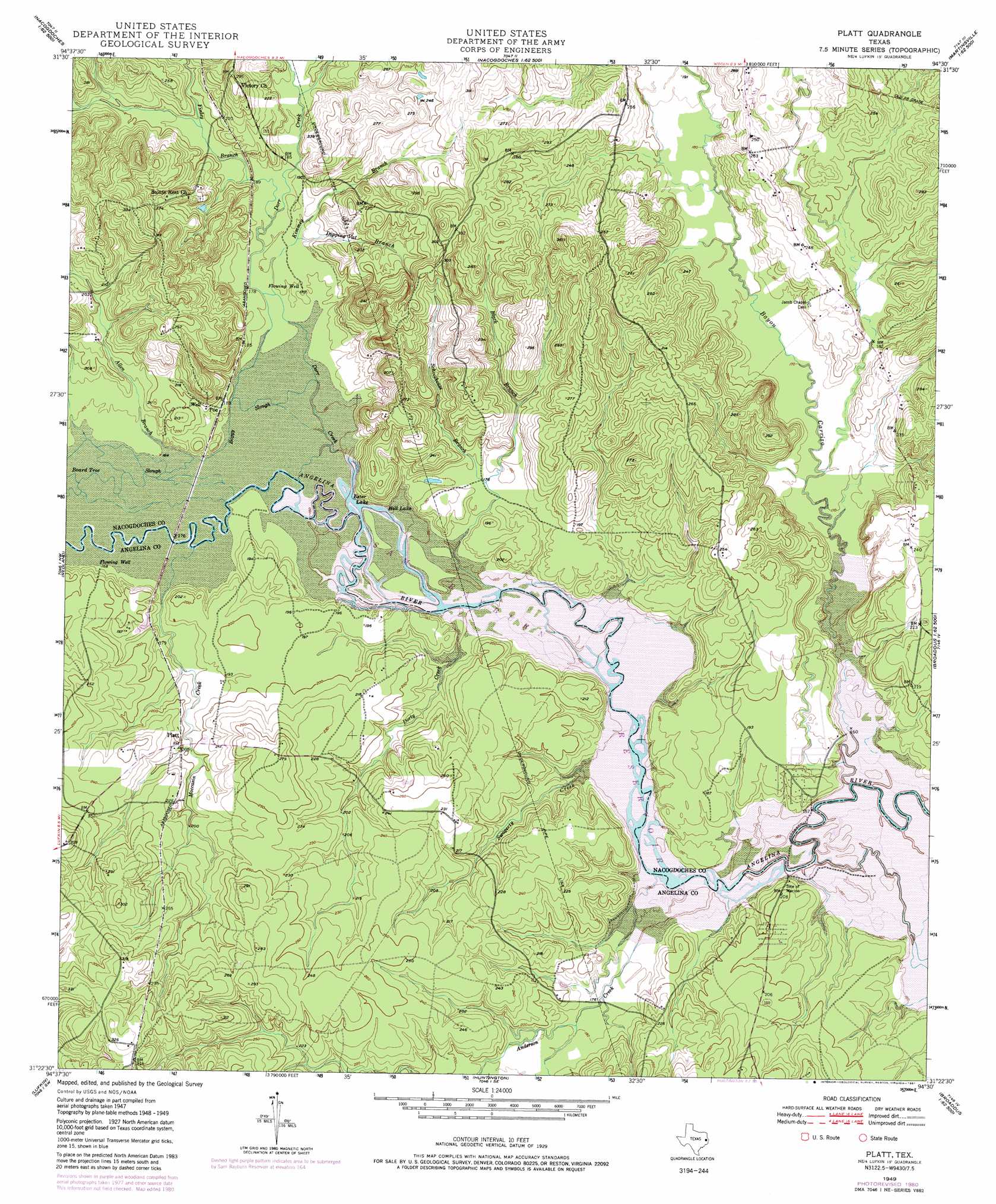
Platt Topo Map Texas
To zoom in, hover over the map of Platt
USGS Topo Quad 31094d5 - 1:24,000 scale
| Topo Map Name: | Platt |
| USGS Topo Quad ID: | 31094d5 |
| Print Size: | ca. 21 1/4" wide x 27" high |
| Southeast Coordinates: | 31.375° N latitude / 94.5° W longitude |
| Map Center Coordinates: | 31.4375° N latitude / 94.5625° W longitude |
| U.S. State: | TX |
| Filename: | o31094d5.jpg |
| Download Map JPG Image: | Platt topo map 1:24,000 scale |
| Map Type: | Topographic |
| Topo Series: | 7.5´ |
| Map Scale: | 1:24,000 |
| Source of Map Images: | United States Geological Survey (USGS) |
| Alternate Map Versions: |
Platt TX 1949, updated 1966 Download PDF Buy paper map Platt TX 1949, updated 1975 Download PDF Buy paper map Platt TX 1949, updated 1981 Download PDF Buy paper map Platt TX 1950 Download PDF Buy paper map Platt TX 2003, updated 2004 Download PDF Buy paper map Platt TX 2010 Download PDF Buy paper map Platt TX 2013 Download PDF Buy paper map Platt TX 2016 Download PDF Buy paper map |
| FStopo: | US Forest Service topo Platt is available: Download FStopo PDF Download FStopo TIF |
1:24,000 Topo Quads surrounding Platt
Lake Nacogdoches North |
Nacogdoches North |
Appleby |
Martinsville |
Mount Herman |
Lake Nacogdoches South |
Nacogdoches South |
Woden |
Melrose |
Chireno North |
Clawson |
Redland |
Platt |
Etoile North |
Chireno South |
Keltys |
Lufkin |
Huntington |
Etoile South |
Broaddus |
Diboll |
Bald Hill |
Manning |
Zavalla |
Cassells-Boykin Park |
> Back to 31094a1 at 1:100,000 scale
> Back to 31094a1 at 1:250,000 scale
> Back to U.S. Topo Maps home
Platt topo map: Gazetteer
Platt: Guts
Board Tree Slough elevation 50m 164′Boggy Slough elevation 50m 164′
Platt: Lakes
Ester Lake elevation 50m 164′Hill Lake elevation 50m 164′
Platt: Parks
Marion Ferry Park elevation 58m 190′Platt: Populated Places
Platt elevation 61m 200′Poe elevation 68m 223′
Platt: Streams
Allen Branch elevation 50m 164′Anderson Creek elevation 50m 164′
Bayou Carrizo elevation 50m 164′
Black Branch elevation 53m 173′
Dipping Vat Branch elevation 54m 177′
Dorr Creek elevation 50m 164′
Dorty Creek elevation 50m 164′
Finley Branch elevation 52m 170′
Kimmey Branch elevation 51m 167′
Moccasin Creek elevation 50m 164′
Puenta Suelas Creek elevation 51m 167′
Schoolhouse Branch elevation 50m 164′
Swagerty Creek elevation 50m 164′
Platt digital topo map on disk
Buy this Platt topo map showing relief, roads, GPS coordinates and other geographical features, as a high-resolution digital map file on DVD: