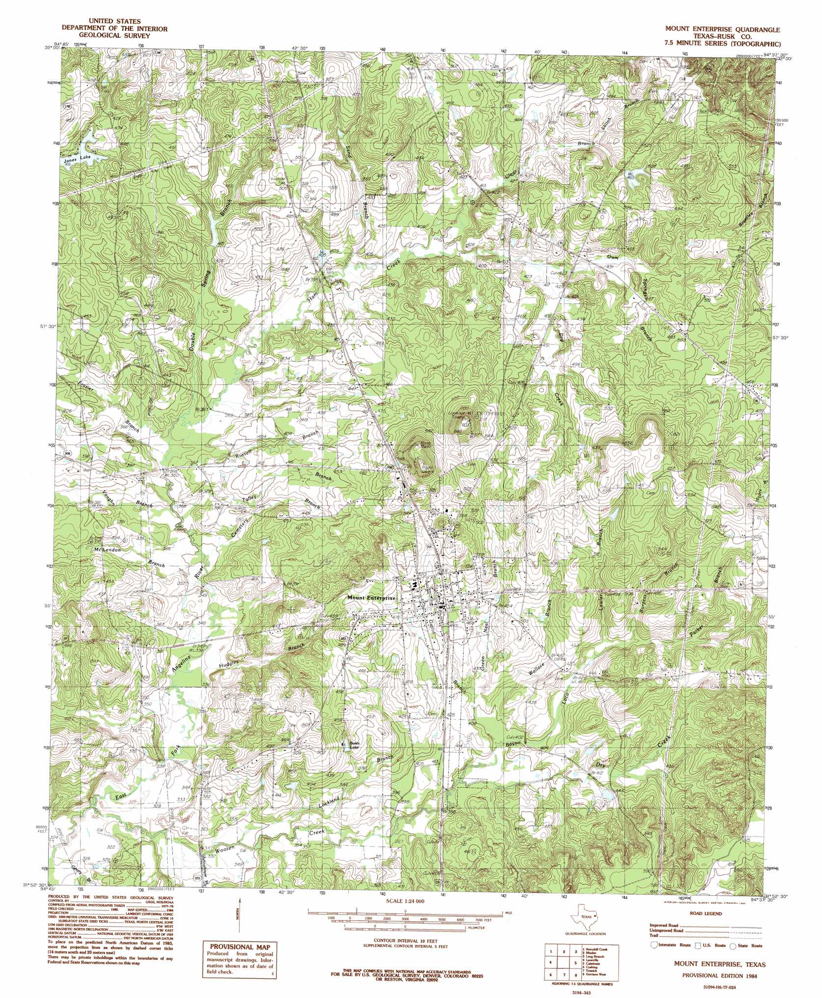
Mount Enterprise Topo Map Texas
To zoom in, hover over the map of Mount Enterprise
USGS Topo Quad 31094h6 - 1:24,000 scale
| Topo Map Name: | Mount Enterprise |
| USGS Topo Quad ID: | 31094h6 |
| Print Size: | ca. 21 1/4" wide x 27" high |
| Southeast Coordinates: | 31.875° N latitude / 94.625° W longitude |
| Map Center Coordinates: | 31.9375° N latitude / 94.6875° W longitude |
| U.S. State: | TX |
| Filename: | o31094h6.jpg |
| Download Map JPG Image: | Mount Enterprise topo map 1:24,000 scale |
| Map Type: | Topographic |
| Topo Series: | 7.5´ |
| Map Scale: | 1:24,000 |
| Source of Map Images: | United States Geological Survey (USGS) |
| Alternate Map Versions: |
Mount Enterprise TX 1984, updated 1985 Download PDF Buy paper map Mount Enterprise TX 2010 Download PDF Buy paper map Mount Enterprise TX 2013 Download PDF Buy paper map Mount Enterprise TX 2016 Download PDF Buy paper map |
1:24,000 Topo Quads surrounding Mount Enterprise
Price |
Henderson |
Church Hill |
Fair Play |
Beckville |
Gum Springs |
Berryhill Creek |
Minden |
Long Branch |
Lake Murvaul |
New Salem |
Laneville |
Mount Enterprise |
Caledonia |
Timpson |
Reklaw |
Cushing |
Trawick |
Garrison West |
Garrison East |
Douglas |
Lake Nacogdoches North |
Nacogdoches North |
Appleby |
Martinsville |
> Back to 31094e1 at 1:100,000 scale
> Back to 31094a1 at 1:250,000 scale
> Back to U.S. Topo Maps home
Mount Enterprise topo map: Gazetteer
Mount Enterprise: Dams
Griffin Lake Dam elevation 121m 396′Mount Enterprise: Lakes
Boles Lake elevation 129m 423′Mount Enterprise: Populated Places
Mount Enterprise elevation 146m 479′Mount Enterprise: Springs
Stockman Spring elevation 112m 367′Mount Enterprise: Streams
Bayou Loco elevation 116m 380′Burgess Branch elevation 134m 439′
Cemetery Branch elevation 105m 344′
Clear Branch elevation 120m 393′
Double Spring Branch elevation 109m 357′
Dry Creek elevation 125m 410′
Dry Creek elevation 116m 380′
Frasier Branch elevation 109m 357′
Gatlin Branch elevation 124m 406′
Gentry Branch elevation 97m 318′
Green Neal Branch elevation 119m 390′
Griffin Branch elevation 111m 364′
Gum Springs Branch elevation 125m 410′
Ham Creek elevation 109m 357′
Hudgins Branch elevation 103m 337′
Lawler Branch elevation 131m 429′
Lockland Branch elevation 107m 351′
McLendon Branch elevation 105m 344′
Parker Branch elevation 134m 439′
Russell Branch elevation 109m 357′
Sand Branch elevation 118m 387′
Schoolhouse Branch elevation 104m 341′
Shiloh Branch elevation 134m 439′
Talley Branch elevation 106m 347′
Vaughn Branch elevation 107m 351′
Wallace Branch elevation 120m 393′
Wooten Creek elevation 97m 318′
Mount Enterprise digital topo map on disk
Buy this Mount Enterprise topo map showing relief, roads, GPS coordinates and other geographical features, as a high-resolution digital map file on DVD: