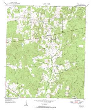
Berea Topo Map Texas
To zoom in, hover over the map of Berea
USGS Topo Quad 31095c3 - 1:24,000 scale
| Topo Map Name: | Berea |
| USGS Topo Quad ID: | 31095c3 |
| Print Size: | ca. 21 1/4" wide x 27" high |
| Southeast Coordinates: | 31.25° N latitude / 95.25° W longitude |
| Map Center Coordinates: | 31.3125° N latitude / 95.3125° W longitude |
| U.S. State: | TX |
| Filename: | o31095c3.jpg |
| Download Map JPG Image: | Berea topo map 1:24,000 scale |
| Map Type: | Topographic |
| Topo Series: | 7.5´ |
| Map Scale: | 1:24,000 |
| Source of Map Images: | United States Geological Survey (USGS) |
| Alternate Map Versions: |
Berea TX 1951 Download PDF Buy paper map Berea TX 2004, updated 2006 Download PDF Buy paper map Berea TX 2011 Download PDF Buy paper map Berea TX 2013 Download PDF Buy paper map Berea TX 2016 Download PDF Buy paper map |
| FStopo: | US Forest Service topo Berea is available: Download FStopo PDF Download FStopo TIF |
1:24,000 Topo Quads surrounding Berea
> Back to 31095a1 at 1:100,000 scale
> Back to 31094a1 at 1:250,000 scale
> Back to U.S. Topo Maps home
Berea topo map: Gazetteer
Berea: Lakes
DryLake elevation 104m 341′Wolf Lake elevation 125m 410′
Berea: Populated Places
Arbor elevation 95m 311′Berea elevation 117m 383′
Hopewell elevation 102m 334′
Berea: Post Offices
Julian Post Office (historical) elevation 134m 439′Berea: Streams
Camp Creek elevation 79m 259′Hick Branch elevation 92m 301′
Lynch Creek elevation 89m 291′
Peachtree Creek elevation 92m 301′
Berea digital topo map on disk
Buy this Berea topo map showing relief, roads, GPS coordinates and other geographical features, as a high-resolution digital map file on DVD:


