Ratcliff Topo Map Texas
To zoom in, hover over the map of Ratcliff
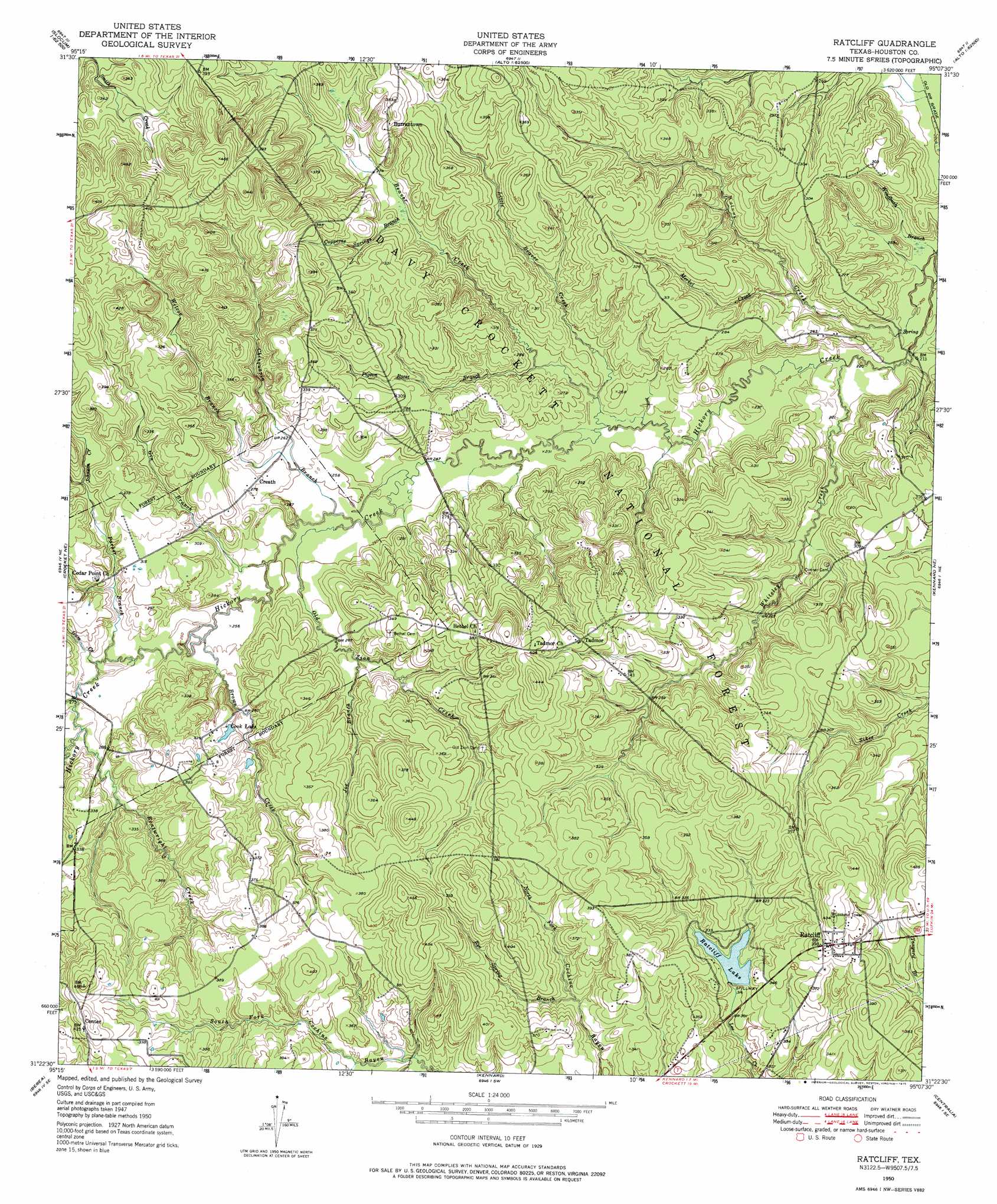
USGS Topo Quad 31095d2 - 1:24,000 scale
| Topo Map Name: | Ratcliff |
| USGS Topo Quad ID: | 31095d2 |
| Print Size: | ca. 21 1/4" wide x 27" high |
| Southeast Coordinates: | 31.375° N latitude / 95.125° W longitude |
| Map Center Coordinates: | 31.4375° N latitude / 95.1875° W longitude |
| U.S. State: | TX |
| Filename: | o31095d2.jpg |
| Download Map JPG Image: | Ratcliff topo map 1:24,000 scale |
| Map Type: | Topographic |
| Topo Series: | 7.5´ |
| Map Scale: | 1:24,000 |
| Source of Map Images: | United States Geological Survey (USGS) |
| Alternate Map Versions: |
Ratcliff TX 1950, updated 1975 Download PDF Buy paper map Ratcliff TX 1951 Download PDF Buy paper map Ratcliff TX 2004, updated 2006 Download PDF Buy paper map Ratcliff TX 2011 Download PDF Buy paper map Ratcliff TX 2013 Download PDF Buy paper map Ratcliff TX 2016 Download PDF Buy paper map |
| FStopo: | US Forest Service topo Ratcliff is available: Download FStopo PDF Download FStopo TIF |
1:24,000 Topo Quads surrounding Ratcliff
Slocum |
Denson Springs |
Pryor Mountain |
Alto |
Douglas |
Percilla |
Augusta |
Weches |
Forest |
Durst Lakes |
Grapeland |
Crockett Ne |
Ratcliff |
Kennard Ne |
Wells |
Crockett |
Berea |
Kennard |
Centralia |
Wells Sw |
Lovelady North |
Fodice |
Pennington |
Crecy |
Apple Springs |
> Back to 31095a1 at 1:100,000 scale
> Back to 31094a1 at 1:250,000 scale
> Back to U.S. Topo Maps home
Ratcliff topo map: Gazetteer
Ratcliff: Bends
Wilcox Branch and Chinquapin Merge elevation 76m 249′Ratcliff: Crossings
Red Lick Ford elevation 62m 203′Ratcliff: Dams
Ratcliff Dam elevation 96m 314′Ratcliff: Lakes
Blue Lake elevation 62m 203′Cook Lake elevation 92m 301′
Ratcliff: Populated Places
Burrantown elevation 110m 360′Center Hill elevation 127m 416′
Creath elevation 83m 272′
Harrison Town elevation 113m 370′
Ratcliff elevation 119m 390′
Tadmor elevation 110m 360′
Ratcliff: Post Offices
Creath Post Office (historical) elevation 82m 269′Ratcliff: Reservoirs
Ratcliff Lake elevation 96m 314′Ratcliff: Springs
Adeline Springs elevation 114m 374′Wallace Springs elevation 105m 344′
Ratcliff: Streams
Beaver Creek elevation 67m 219′Boatwright Creek elevation 82m 269′
Brown Creek elevation 75m 246′
Chinguapin Branch elevation 73m 239′
Copperas Springs Branch elevation 80m 262′
Gin Branch elevation 76m 249′
Gum Creek elevation 79m 259′
Joe Branch elevation 82m 269′
Johnson Creek elevation 90m 295′
Little Beaver Creek elevation 70m 229′
Merkel Creek elevation 67m 219′
Old Zion Creek elevation 73m 239′
Parker Branch elevation 79m 259′
Pigeon Roost Branch elevation 74m 242′
Rosy Bayou elevation 79m 259′
Rye Spring Branch elevation 94m 308′
Sikes Creek elevation 81m 265′
Smith Creek elevation 92m 301′
Walnut Creek elevation 61m 200′
Whiteley Creek elevation 64m 209′
Wilcox Branch elevation 79m 259′
Windbush Branch elevation 61m 200′
Ratcliff: Trails
Ratcliff Lake Trail elevation 96m 314′Ratcliff digital topo map on disk
Buy this Ratcliff topo map showing relief, roads, GPS coordinates and other geographical features, as a high-resolution digital map file on DVD: