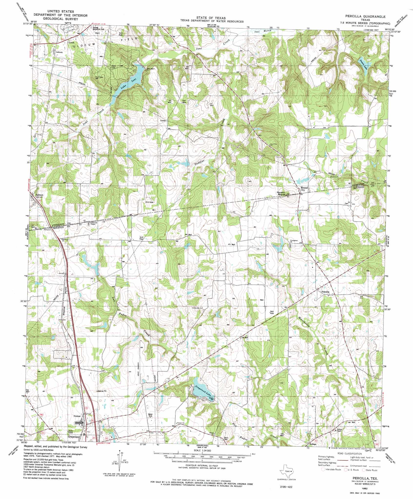
Percilla Topo Map Texas
To zoom in, hover over the map of Percilla
USGS Topo Quad 31095e4 - 1:24,000 scale
| Topo Map Name: | Percilla |
| USGS Topo Quad ID: | 31095e4 |
| Print Size: | ca. 21 1/4" wide x 27" high |
| Southeast Coordinates: | 31.5° N latitude / 95.375° W longitude |
| Map Center Coordinates: | 31.5625° N latitude / 95.4375° W longitude |
| U.S. State: | TX |
| Filename: | o31095e4.jpg |
| Download Map JPG Image: | Percilla topo map 1:24,000 scale |
| Map Type: | Topographic |
| Topo Series: | 7.5´ |
| Map Scale: | 1:24,000 |
| Source of Map Images: | United States Geological Survey (USGS) |
| Alternate Map Versions: |
Percilla TX 1982, updated 1982 Download PDF Buy paper map Percilla TX 2010 Download PDF Buy paper map Percilla TX 2013 Download PDF Buy paper map Percilla TX 2016 Download PDF Buy paper map |
1:24,000 Topo Quads surrounding Percilla
Northwest Palestine |
Northeast Palestine |
Neches |
Maydelle |
Rusk |
Southwest Palestine |
Southeast Palestine |
Slocum |
Denson Springs |
Pryor Mountain |
Indian Lake |
Elkhart Creek |
Percilla |
Augusta |
Weches |
Stanmire Lake |
Hays Spring |
Grapeland |
Crockett Ne |
Ratcliff |
Halls Bluff |
Porter Springs |
Crockett |
Berea |
Kennard |
> Back to 31095e1 at 1:100,000 scale
> Back to 31094a1 at 1:250,000 scale
> Back to U.S. Topo Maps home
Percilla topo map: Gazetteer
Percilla: Crossings
Union Crossing elevation 142m 465′Percilla: Dams
Grapeland Lake Dam elevation 106m 347′Ioni Lake Dam elevation 107m 351′
Murphy Dam elevation 128m 419′
Wilkins Dam elevation 135m 442′
Percilla: Parks
Houston Mound Historical Marker elevation 155m 508′Strong Memorial Park elevation 147m 482′
Percilla: Populated Places
Mound City elevation 148m 485′Mound City elevation 146m 479′
Percilla elevation 130m 426′
Refuge elevation 98m 321′
Salmon elevation 155m 508′
Percilla: Reservoirs
Grapeland Lake elevation 116m 380′Ioni Lake elevation 107m 351′
Murphy Lake elevation 128m 419′
Wilkins Lake elevation 135m 442′
Percilla: Springs
Green Springs elevation 130m 426′Yarborough Springs elevation 134m 439′
Percilla: Streams
Saddler Creek elevation 99m 324′Story Springs elevation 112m 367′
Percilla: Summits
Houston Mound elevation 168m 551′Percilla: Swamps
Ioni Marsh elevation 99m 324′Mill Branch elevation 117m 383′
Percilla digital topo map on disk
Buy this Percilla topo map showing relief, roads, GPS coordinates and other geographical features, as a high-resolution digital map file on DVD: