Southeast Palestine Topo Map Texas
To zoom in, hover over the map of Southeast Palestine
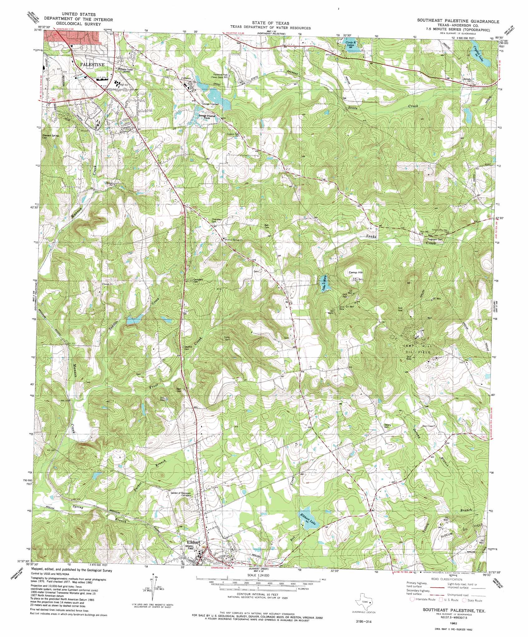
USGS Topo Quad 31095f5 - 1:24,000 scale
| Topo Map Name: | Southeast Palestine |
| USGS Topo Quad ID: | 31095f5 |
| Print Size: | ca. 21 1/4" wide x 27" high |
| Southeast Coordinates: | 31.625° N latitude / 95.5° W longitude |
| Map Center Coordinates: | 31.6875° N latitude / 95.5625° W longitude |
| U.S. State: | TX |
| Filename: | o31095f5.jpg |
| Download Map JPG Image: | Southeast Palestine topo map 1:24,000 scale |
| Map Type: | Topographic |
| Topo Series: | 7.5´ |
| Map Scale: | 1:24,000 |
| Source of Map Images: | United States Geological Survey (USGS) |
| Alternate Map Versions: |
Southeast Palestine TX 1982, updated 1982 Download PDF Buy paper map Southeast Palestine TX 2010 Download PDF Buy paper map Southeast Palestine TX 2013 Download PDF Buy paper map Southeast Palestine TX 2016 Download PDF Buy paper map |
1:24,000 Topo Quads surrounding Southeast Palestine
Blackfoot |
Wilkerson Mountain |
Pert |
Todd City |
Jacksonville West |
Tennessee Colony |
Northwest Palestine |
Northeast Palestine |
Neches |
Maydelle |
Long Lake |
Southwest Palestine |
Southeast Palestine |
Slocum |
Denson Springs |
Oakwood |
Indian Lake |
Elkhart Creek |
Percilla |
Augusta |
Lake Leon |
Stanmire Lake |
Hays Spring |
Grapeland |
Crockett Ne |
> Back to 31095e1 at 1:100,000 scale
> Back to 31094a1 at 1:250,000 scale
> Back to U.S. Topo Maps home
Southeast Palestine topo map: Gazetteer
Southeast Palestine: Dams
Broyles Lake Dam elevation 135m 442′Calhoun Lake Number 1 Dam elevation 125m 410′
Calhoun Lake Number 2 Dam elevation 119m 390′
Circle R Dam Number 1 elevation 118m 387′
Crystal Lake Dam elevation 107m 351′
Elkhart Lake Dam elevation 114m 374′
Lake Mary Dam elevation 139m 456′
Southeast Palestine: Lakes
Elkhart Lake elevation 111m 364′Lake Mary elevation 144m 472′
Southeast Palestine: Oilfields
Camp Hill Oil Field elevation 204m 669′Southeast Palestine: Parks
Texas State Railroad State Historical Park elevation 135m 442′Southeast Palestine: Populated Places
Cronin elevation 91m 298′Crystal Lake elevation 101m 331′
Deanwright elevation 116m 380′
Elkhart elevation 117m 383′
Southeast Palestine: Reservoirs
Broyles Lake elevation 135m 442′Calhoun Lake Number 1 elevation 125m 410′
Calhoun Lake Number 2 elevation 119m 390′
Circle R Lake Number 1 elevation 118m 387′
Crystal Lake elevation 105m 344′
Elkhart Lake elevation 114m 374′
Lake Mary elevation 139m 456′
Southeast Palestine: Streams
Delany Branch elevation 111m 364′Frost Creek elevation 88m 288′
Parker Branch elevation 91m 298′
Saddler Creek elevation 90m 295′
Spring Branch elevation 84m 275′
Southeast Palestine: Summits
Camp Hill elevation 199m 652′Southeast Palestine digital topo map on disk
Buy this Southeast Palestine topo map showing relief, roads, GPS coordinates and other geographical features, as a high-resolution digital map file on DVD: