Camp Creek Lake Topo Map Texas
To zoom in, hover over the map of Camp Creek Lake
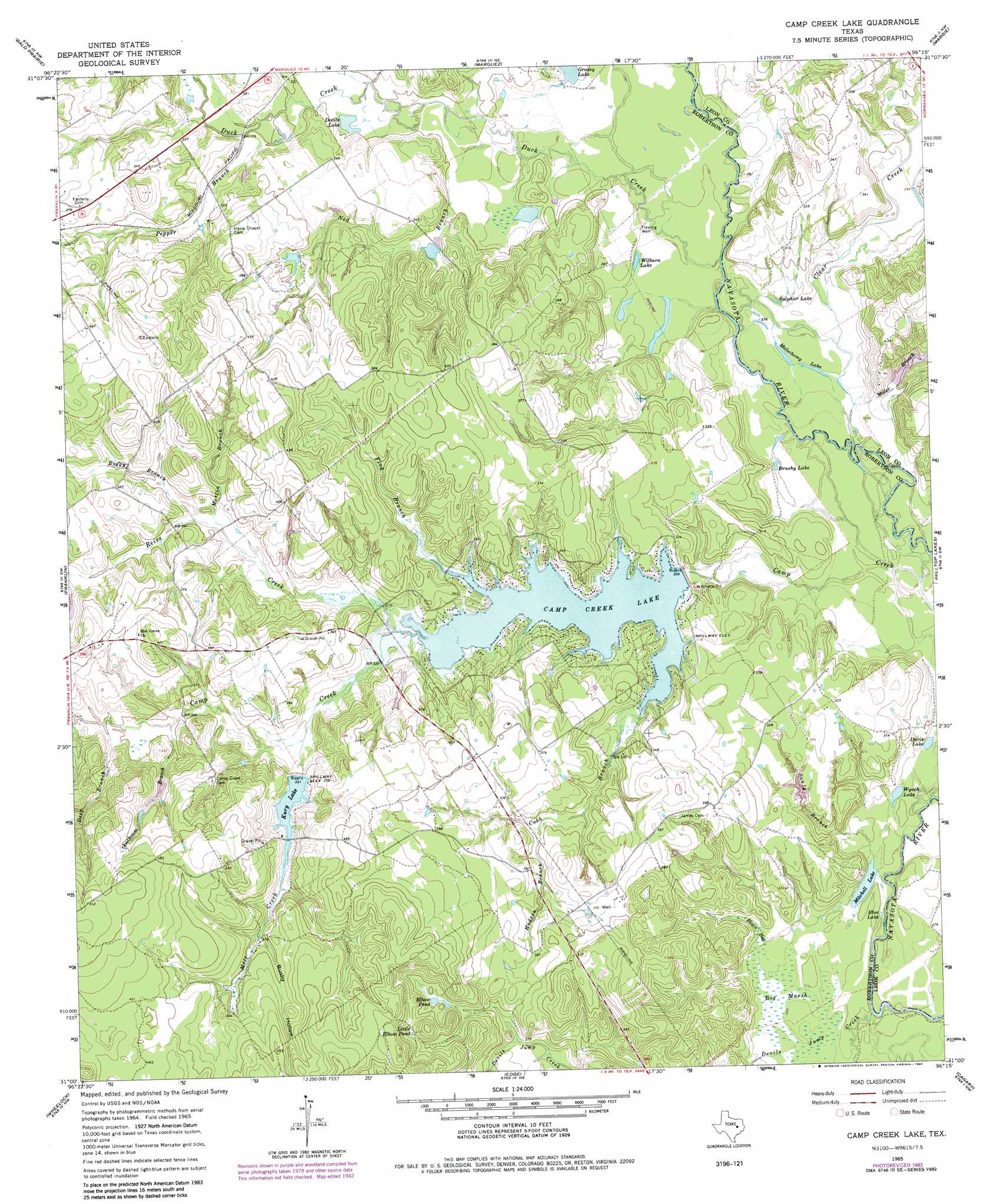
USGS Topo Quad 31096a3 - 1:24,000 scale
| Topo Map Name: | Camp Creek Lake |
| USGS Topo Quad ID: | 31096a3 |
| Print Size: | ca. 21 1/4" wide x 27" high |
| Southeast Coordinates: | 31° N latitude / 96.25° W longitude |
| Map Center Coordinates: | 31.0625° N latitude / 96.3125° W longitude |
| U.S. State: | TX |
| Filename: | o31096a3.jpg |
| Download Map JPG Image: | Camp Creek Lake topo map 1:24,000 scale |
| Map Type: | Topographic |
| Topo Series: | 7.5´ |
| Map Scale: | 1:24,000 |
| Source of Map Images: | United States Geological Survey (USGS) |
| Alternate Map Versions: |
Camp Creek Lake TX 1965, updated 1967 Download PDF Buy paper map Camp Creek Lake TX 1965, updated 1983 Download PDF Buy paper map Camp Creek Lake TX 2010 Download PDF Buy paper map Camp Creek Lake TX 2013 Download PDF Buy paper map Camp Creek Lake TX 2016 Download PDF Buy paper map |
1:24,000 Topo Quads surrounding Camp Creek Lake
Kosse East |
Oletha |
Round Prairie |
Jewett |
Robbins |
Petteway |
Bald Prairie |
Marquez |
Margie |
Spring Seat |
Owensville |
Franklin |
Camp Creek Lake |
Hilltop Lakes |
Normangee |
Hearne North |
Wheelock |
Edge |
Canary |
North Zulch |
Hearne South |
Dunn Creek |
Kurten |
Clear Lake |
Iola |
> Back to 31096a1 at 1:100,000 scale
> Back to 31096a1 at 1:250,000 scale
> Back to U.S. Topo Maps home
Camp Creek Lake topo map: Gazetteer
Camp Creek Lake: Dams
Camp Creek Lake Dam elevation 94m 308′W D Kury Dam elevation 107m 351′
Camp Creek Lake: Lakes
Blue Lake elevation 81m 265′Brushy Lake elevation 82m 269′
Davis Lake elevation 81m 265′
Devils Lake elevation 91m 298′
Malochomy Lake elevation 84m 275′
Mitchell Lake elevation 80m 262′
Sulphur Lake elevation 84m 275′
Wilburn Lake elevation 85m 278′
Wyach Lake elevation 81m 265′
Camp Creek Lake: Reservoirs
Camp Creek Lake elevation 89m 291′Elbow Pond elevation 118m 387′
Kury Lake elevation 110m 360′
Little Elbow Pond elevation 126m 413′
Camp Creek Lake: Streams
Boggy Branch elevation 103m 337′Clear Creek elevation 82m 269′
Cobb Branch elevation 97m 318′
Deep Branch elevation 107m 351′
Devils Jump Creek elevation 79m 259′
Duck Creek elevation 84m 275′
Flag Branch elevation 98m 321′
Goathouse Branch elevation 104m 341′
Hudson Branch elevation 104m 341′
Mill Creek elevation 99m 324′
Miller Branch elevation 83m 272′
Morton Branch elevation 101m 331′
Ned Branch elevation 88m 288′
Pepper Branch elevation 92m 301′
Reiss Creek elevation 95m 311′
Sandy Branch elevation 81m 265′
Camp Creek Lake: Swamps
Big Marsh elevation 81m 265′Black Bay elevation 83m 272′
Camp Creek Lake: Valleys
Busby Hollow elevation 119m 390′Camp Creek Lake digital topo map on disk
Buy this Camp Creek Lake topo map showing relief, roads, GPS coordinates and other geographical features, as a high-resolution digital map file on DVD: