Round Prairie Topo Map Texas
To zoom in, hover over the map of Round Prairie
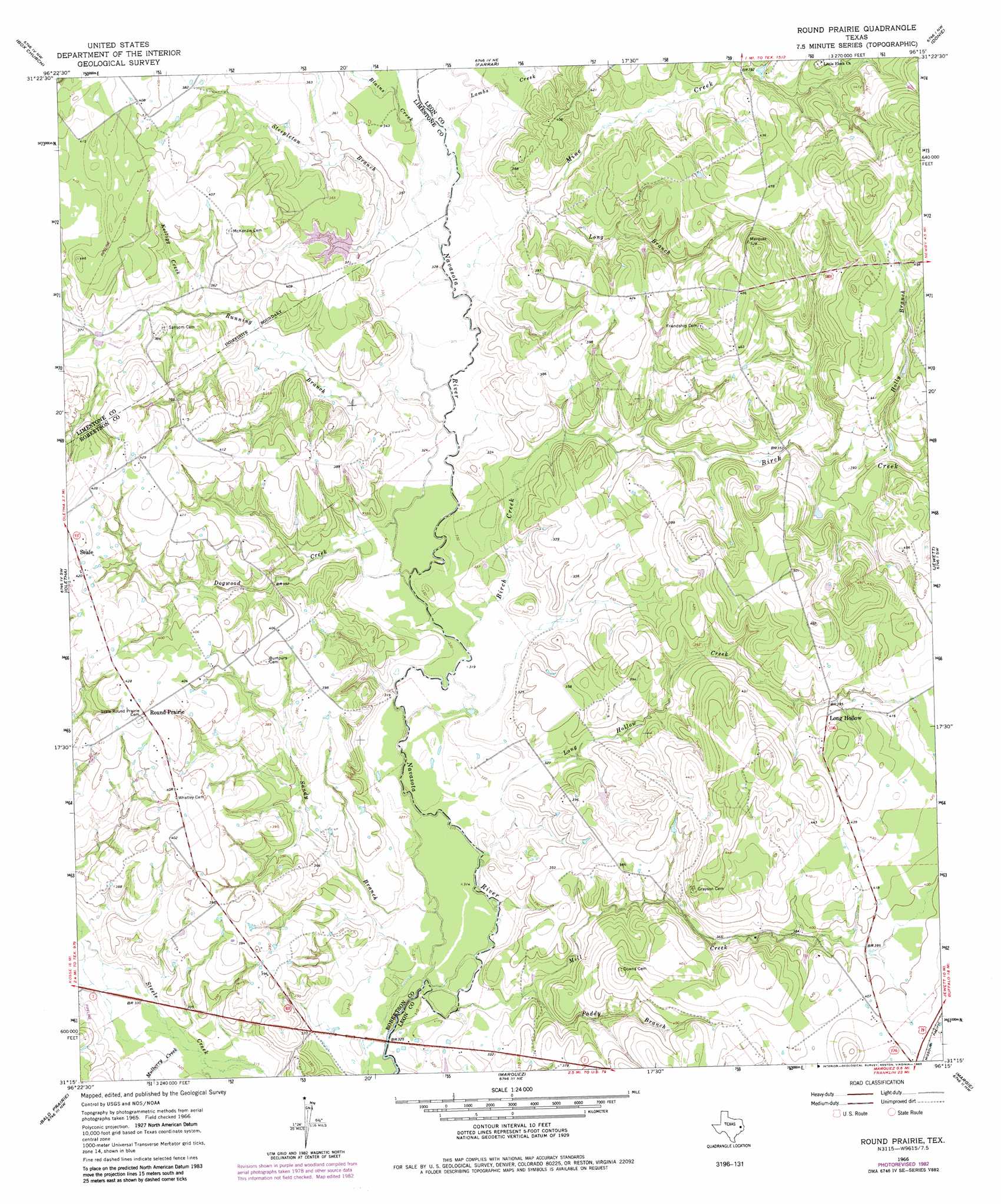
USGS Topo Quad 31096c3 - 1:24,000 scale
| Topo Map Name: | Round Prairie |
| USGS Topo Quad ID: | 31096c3 |
| Print Size: | ca. 21 1/4" wide x 27" high |
| Southeast Coordinates: | 31.25° N latitude / 96.25° W longitude |
| Map Center Coordinates: | 31.3125° N latitude / 96.3125° W longitude |
| U.S. State: | TX |
| Filename: | o31096c3.jpg |
| Download Map JPG Image: | Round Prairie topo map 1:24,000 scale |
| Map Type: | Topographic |
| Topo Series: | 7.5´ |
| Map Scale: | 1:24,000 |
| Source of Map Images: | United States Geological Survey (USGS) |
| Alternate Map Versions: |
Round Prairie TX 1966, updated 1968 Download PDF Buy paper map Round Prairie TX 1966, updated 1982 Download PDF Buy paper map Round Prairie TX 1966, updated 1983 Download PDF Buy paper map Round Prairie TX 2011 Download PDF Buy paper map Round Prairie TX 2013 Download PDF Buy paper map Round Prairie TX 2016 Download PDF Buy paper map |
1:24,000 Topo Quads surrounding Round Prairie
Groesbeck |
Fallon |
Teague South |
Dew |
Lanely |
Thornton |
Box Church |
Farrar |
Donie |
Buffalo |
Kosse East |
Oletha |
Round Prairie |
Jewett |
Robbins |
Petteway |
Bald Prairie |
Marquez |
Margie |
Spring Seat |
Owensville |
Franklin |
Camp Creek Lake |
Hilltop Lakes |
Normangee |
> Back to 31096a1 at 1:100,000 scale
> Back to 31096a1 at 1:250,000 scale
> Back to U.S. Topo Maps home
Round Prairie topo map: Gazetteer
Round Prairie: Dams
Sterling C Robertson Dam elevation 104m 341′Round Prairie: Populated Places
Long Hollow elevation 125m 410′Round Prairie elevation 128m 419′
Seale elevation 128m 419′
Seale elevation 128m 419′
Round Prairie: Reservoirs
Lake Limestone elevation 104m 341′Round Prairie: Streams
Birch Creek elevation 96m 314′Blains Creek elevation 107m 351′
Dogwood Creek elevation 99m 324′
Dogwood Creek elevation 98m 321′
Holly Branch elevation 110m 360′
Kellogg Creek elevation 107m 351′
Lambs Creek elevation 107m 351′
Lies Branch elevation 107m 351′
Long Branch elevation 107m 351′
Long Hollow Creek elevation 95m 311′
Mill Creek elevation 94m 308′
Mine Creek elevation 107m 351′
Mulberry Creek elevation 97m 318′
Paddy Branch elevation 98m 321′
Running Branch elevation 107m 351′
Sandy Branch elevation 93m 305′
Steepleton Branch elevation 107m 351′
Round Prairie digital topo map on disk
Buy this Round Prairie topo map showing relief, roads, GPS coordinates and other geographical features, as a high-resolution digital map file on DVD: