Teague South Topo Map Texas
To zoom in, hover over the map of Teague South
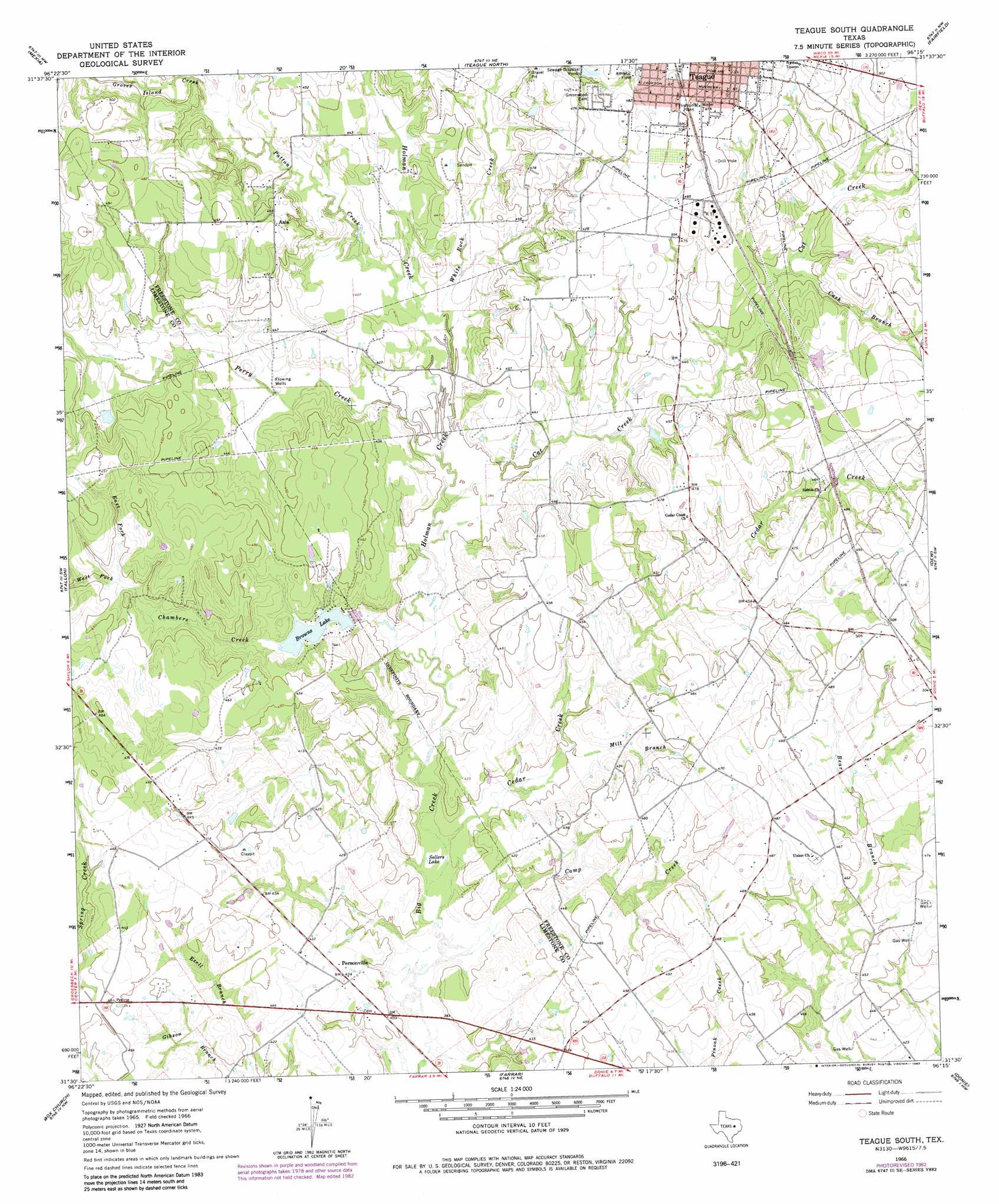
USGS Topo Quad 31096e3 - 1:24,000 scale
| Topo Map Name: | Teague South |
| USGS Topo Quad ID: | 31096e3 |
| Print Size: | ca. 21 1/4" wide x 27" high |
| Southeast Coordinates: | 31.5° N latitude / 96.25° W longitude |
| Map Center Coordinates: | 31.5625° N latitude / 96.3125° W longitude |
| U.S. State: | TX |
| Filename: | o31096e3.jpg |
| Download Map JPG Image: | Teague South topo map 1:24,000 scale |
| Map Type: | Topographic |
| Topo Series: | 7.5´ |
| Map Scale: | 1:24,000 |
| Source of Map Images: | United States Geological Survey (USGS) |
| Alternate Map Versions: |
Teague South TX 1966, updated 1968 Download PDF Buy paper map Teague South TX 1966, updated 1983 Download PDF Buy paper map Teague South TX 2010 Download PDF Buy paper map Teague South TX 2013 Download PDF Buy paper map Teague South TX 2016 Download PDF Buy paper map |
1:24,000 Topo Quads surrounding Teague South
Union High |
Wortham |
Kirvin |
Stewards Mill |
Young |
Tehuacana |
Mexia |
Teague North |
Fairfield |
Turlington |
Groesbeck |
Fallon |
Teague South |
Dew |
Lanely |
Thornton |
Box Church |
Farrar |
Donie |
Buffalo |
Kosse East |
Oletha |
Round Prairie |
Jewett |
Robbins |
> Back to 31096e1 at 1:100,000 scale
> Back to 31096a1 at 1:250,000 scale
> Back to U.S. Topo Maps home
Teague South topo map: Gazetteer
Teague South: Dams
Browns Dam elevation 123m 403′Teague South: Lakes
Sellers Lake elevation 116m 380′Teague South: Populated Places
Personville elevation 128m 419′Teague South: Reservoirs
Browns Lake elevation 123m 403′Teague South: Streams
Camp Creek elevation 113m 370′Cash Branch elevation 134m 439′
Cat Creek elevation 119m 390′
Cedar Creek elevation 116m 380′
Chambers Creek elevation 116m 380′
East Fork Chambers Creek elevation 133m 436′
Grove Island Creek elevation 131m 429′
Holman Creek elevation 116m 380′
Mill Branch elevation 122m 400′
Patton Creek elevation 124m 406′
Perry Creek elevation 119m 390′
West Fork Chambers Creek elevation 133m 436′
White Rock Creek elevation 122m 400′
Teague South digital topo map on disk
Buy this Teague South topo map showing relief, roads, GPS coordinates and other geographical features, as a high-resolution digital map file on DVD: