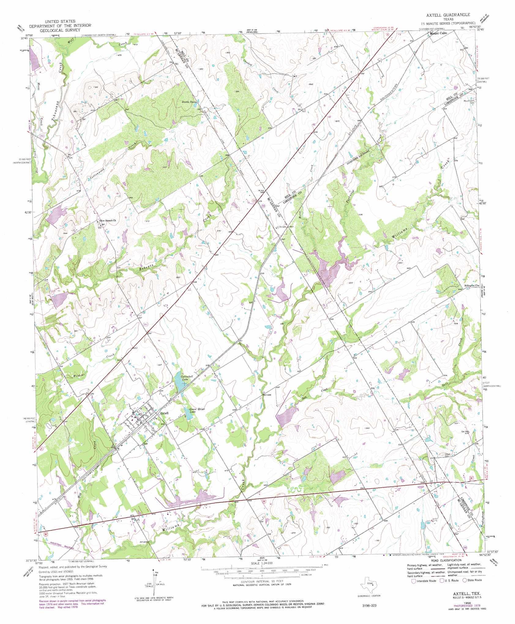
Axtell Topo Map Texas
To zoom in, hover over the map of Axtell
USGS Topo Quad 31096f8 - 1:24,000 scale
| Topo Map Name: | Axtell |
| USGS Topo Quad ID: | 31096f8 |
| Print Size: | ca. 21 1/4" wide x 27" high |
| Southeast Coordinates: | 31.625° N latitude / 96.875° W longitude |
| Map Center Coordinates: | 31.6875° N latitude / 96.9375° W longitude |
| U.S. State: | TX |
| Filename: | o31096f8.jpg |
| Download Map JPG Image: | Axtell topo map 1:24,000 scale |
| Map Type: | Topographic |
| Topo Series: | 7.5´ |
| Map Scale: | 1:24,000 |
| Source of Map Images: | United States Geological Survey (USGS) |
| Alternate Map Versions: |
Axtell TX 1956, updated 1957 Download PDF Buy paper map Axtell TX 1956, updated 1978 Download PDF Buy paper map Axtell TX 2010 Download PDF Buy paper map Axtell TX 2013 Download PDF Buy paper map Axtell TX 2016 Download PDF Buy paper map |
1:24,000 Topo Quads surrounding Axtell
Peoria |
Abbott |
Malone |
Irene |
Dawson |
Aquilla |
West |
Penelope |
Hubbard |
Coolidge |
Gholson |
Elm Mott |
Axtell |
Prairie Hill |
Echols |
Waco West |
Waco East |
Elk |
Mart |
Ben Hur |
Lorena |
Robinson |
Riesel |
Otto |
Odds |
> Back to 31096e1 at 1:100,000 scale
> Back to 31096a1 at 1:250,000 scale
> Back to U.S. Topo Maps home
Axtell topo map: Gazetteer
Axtell: Dams
Cottonbell Lake Dam elevation 155m 508′Soil Conservation Service Site 11 Dam elevation 134m 439′
Soil Conservation Service Site 12 Dam elevation 138m 452′
Soil Conservation Service Site 19 Dam elevation 152m 498′
Soil Conservation Service Site 20 Dam elevation 155m 508′
Soil Conservation Service Site 21 Dam elevation 146m 479′
Soil Conservation Service Site 22 Dam elevation 151m 495′
Soil Conservation Service Site 23 Dam elevation 155m 508′
Soil Conservation Service Site 24 Dam elevation 138m 452′
Soil Conservation Service Site 8 Dam elevation 140m 459′
Axtell: Populated Places
Axtell elevation 160m 524′Axtell: Reservoirs
Cottonbell Lake elevation 159m 521′Double Tanks elevation 166m 544′
Green Briar Lake elevation 149m 488′
Soil Conservation Service Site 11 Reservoir elevation 134m 439′
Soil Conservation Service Site 12 Reservoir elevation 138m 452′
Soil Conservation Service Site 19 Reservoir elevation 152m 498′
Soil Conservation Service Site 20 Reservoir elevation 155m 508′
Soil Conservation Service Site 21 Reservoir elevation 146m 479′
Soil Conservation Service Site 22 Reservoir elevation 151m 495′
Soil Conservation Service Site 23 Reservoir elevation 155m 508′
Soil Conservation Service Site 24 Reservoir elevation 138m 452′
Soil Conservation Service Site 8 Reservoir elevation 140m 459′
Axtell: Streams
Horse Creek elevation 152m 498′Moose Creek elevation 134m 439′
Packwood Creek elevation 157m 515′
Salt Creek elevation 138m 452′
Wolf Creek elevation 140m 459′
Axtell digital topo map on disk
Buy this Axtell topo map showing relief, roads, GPS coordinates and other geographical features, as a high-resolution digital map file on DVD: