Young Topo Map Texas
To zoom in, hover over the map of Young
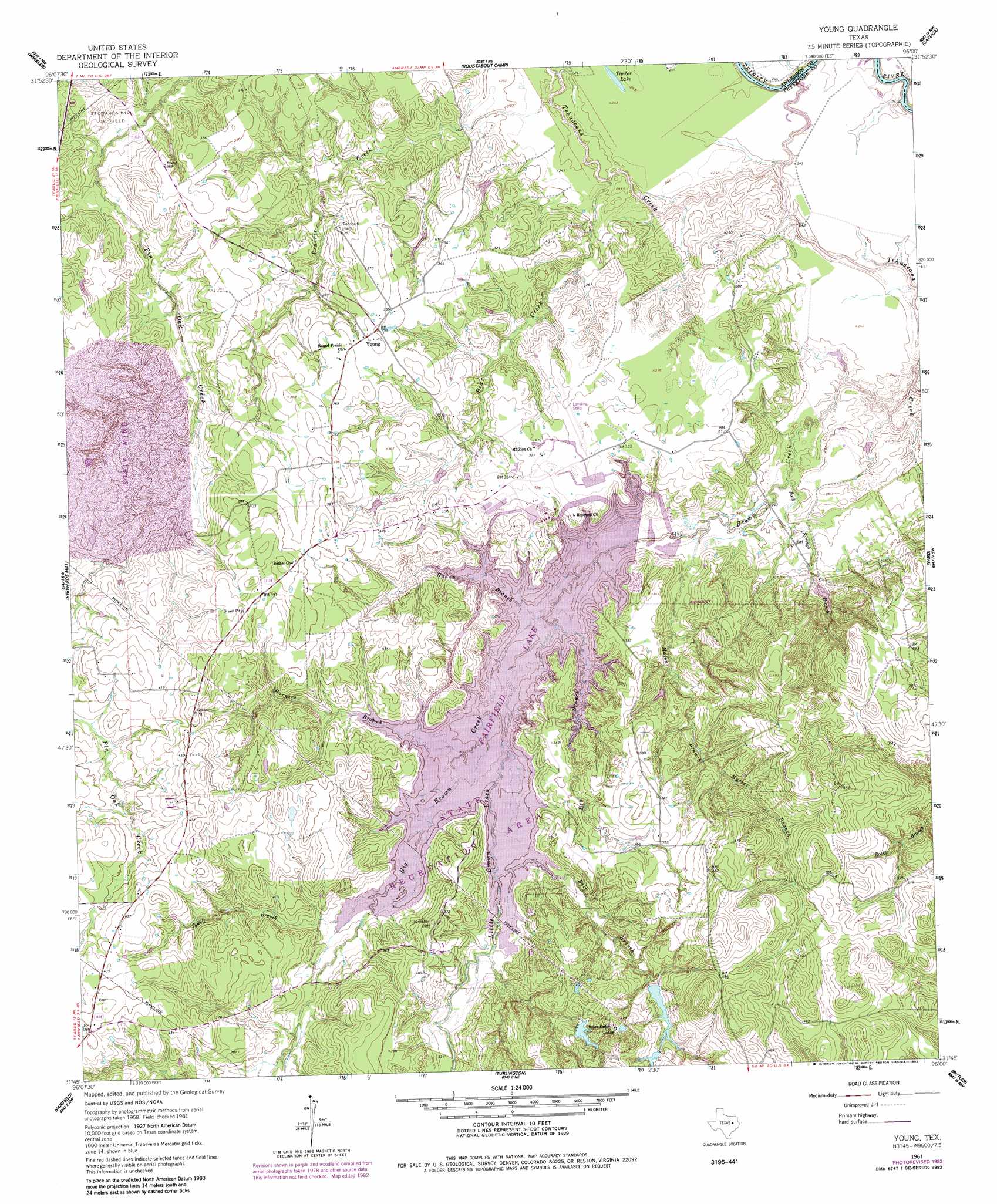
USGS Topo Quad 31096g1 - 1:24,000 scale
| Topo Map Name: | Young |
| USGS Topo Quad ID: | 31096g1 |
| Print Size: | ca. 21 1/4" wide x 27" high |
| Southeast Coordinates: | 31.75° N latitude / 96° W longitude |
| Map Center Coordinates: | 31.8125° N latitude / 96.0625° W longitude |
| U.S. State: | TX |
| Filename: | o31096g1.jpg |
| Download Map JPG Image: | Young topo map 1:24,000 scale |
| Map Type: | Topographic |
| Topo Series: | 7.5´ |
| Map Scale: | 1:24,000 |
| Source of Map Images: | United States Geological Survey (USGS) |
| Alternate Map Versions: |
Young TX 1961, updated 1962 Download PDF Buy paper map Young TX 1961, updated 1975 Download PDF Buy paper map Young TX 1961, updated 1983 Download PDF Buy paper map Young TX 2010 Download PDF Buy paper map Young TX 2013 Download PDF Buy paper map Young TX 2016 Download PDF Buy paper map |
1:24,000 Topo Quads surrounding Young
Powell |
Goodlow Park |
Creslenn Ranch |
Cross Roads |
Coon Creek Lake |
Streetman |
Winkler |
Roustabout Camp |
Cayuga |
Blackfoot |
Kirvin |
Stewards Mill |
Young |
Yard |
Tennessee Colony |
Teague North |
Fairfield |
Turlington |
Butler |
Long Lake |
Teague South |
Dew |
Lanely |
Keechi |
Oakwood |
> Back to 31096e1 at 1:100,000 scale
> Back to 31096a1 at 1:250,000 scale
> Back to U.S. Topo Maps home
Young topo map: Gazetteer
Young: Airports
Big Brown Creek Airstrip elevation 98m 321′Young: Dams
Couch Lake Dam elevation 118m 387′Fairfield Dam elevation 92m 301′
Young: Lakes
Timber Lake elevation 75m 246′Young: Parks
Fairfield Lake State Park elevation 99m 324′Young: Populated Places
Young elevation 110m 360′Young: Reservoirs
Couch Lake elevation 118m 387′Fairfield Lake elevation 92m 301′
Young: Streams
Ball Branch elevation 91m 298′Bear Creek elevation 73m 239′
Big Brown Creek elevation 70m 229′
Dry Branch elevation 91m 298′
Hanna Branch elevation 91m 298′
Harpers Branch elevation 91m 298′
Little Brown Creek elevation 91m 298′
Malone Branch elevation 77m 252′
Myrtal Branch elevation 94m 308′
Powell Branch elevation 91m 298′
Prairie Creek elevation 71m 232′
Rock Springs Branch elevation 73m 239′
Young: Trails
Fairfield Lake State Park Trails elevation 91m 298′Young digital topo map on disk
Buy this Young topo map showing relief, roads, GPS coordinates and other geographical features, as a high-resolution digital map file on DVD: