Roustabout Camp Topo Map Texas
To zoom in, hover over the map of Roustabout Camp
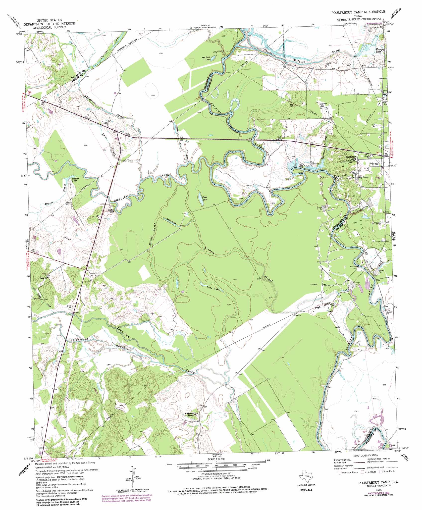
USGS Topo Quad 31096h1 - 1:24,000 scale
| Topo Map Name: | Roustabout Camp |
| USGS Topo Quad ID: | 31096h1 |
| Print Size: | ca. 21 1/4" wide x 27" high |
| Southeast Coordinates: | 31.875° N latitude / 96° W longitude |
| Map Center Coordinates: | 31.9375° N latitude / 96.0625° W longitude |
| U.S. State: | TX |
| Filename: | o31096h1.jpg |
| Download Map JPG Image: | Roustabout Camp topo map 1:24,000 scale |
| Map Type: | Topographic |
| Topo Series: | 7.5´ |
| Map Scale: | 1:24,000 |
| Source of Map Images: | United States Geological Survey (USGS) |
| Alternate Map Versions: |
Roustabout Camp TX 1960, updated 1961 Download PDF Buy paper map Roustabout Camp TX 1960, updated 1975 Download PDF Buy paper map Roustabout Camp TX 1960, updated 1984 Download PDF Buy paper map Roustabout Camp TX 1960, updated 1984 Download PDF Buy paper map Roustabout Camp TX 2010 Download PDF Buy paper map Roustabout Camp TX 2013 Download PDF Buy paper map Roustabout Camp TX 2016 Download PDF Buy paper map |
1:24,000 Topo Quads surrounding Roustabout Camp
Bazette |
Kerens |
Malakoff |
Mallard Hill |
Athens |
Powell |
Goodlow Park |
Creslenn Ranch |
Cross Roads |
Coon Creek Lake |
Streetman |
Winkler |
Roustabout Camp |
Cayuga |
Blackfoot |
Kirvin |
Stewards Mill |
Young |
Yard |
Tennessee Colony |
Teague North |
Fairfield |
Turlington |
Butler |
Long Lake |
> Back to 31096e1 at 1:100,000 scale
> Back to 31096a1 at 1:250,000 scale
> Back to U.S. Topo Maps home
Roustabout Camp topo map: Gazetteer
Roustabout Camp: Cliffs
Allen Bluff elevation 77m 252′Cox Bluff elevation 76m 249′
Lindsey Bluff elevation 72m 236′
Walker Bluff elevation 70m 229′
Roustabout Camp: Guts
Hillside Slough elevation 76m 249′Lindsey Slough elevation 73m 239′
Yonker Pin Slough elevation 77m 252′
Roustabout Camp: Lakes
Carroll Lake elevation 78m 255′Long Lake elevation 76m 249′
Lost Lake elevation 76m 249′
Pea Patch Lake elevation 78m 255′
Rampy Lake elevation 81m 265′
Snag Lake elevation 76m 249′
Walker Lake elevation 78m 255′
Roustabout Camp: Parks
Richland Creek Wildlife Management Area elevation 77m 252′Roustabout Camp: Reservoirs
Richland-Chambers Reservoir elevation 70m 229′Roustabout Camp: Ridges
High Ridge elevation 81m 265′Roustabout Camp: Streams
Alligator Creek elevation 71m 232′Cottonwood Creek elevation 74m 242′
Enloe Slough elevation 76m 249′
Little Sandy Creek elevation 76m 249′
Pin Oak Creek elevation 76m 249′
Prairie Creek elevation 73m 239′
Richland Creek elevation 68m 223′
Sycamore Creek elevation 77m 252′
Wildcat Creek elevation 71m 232′
Roustabout Camp digital topo map on disk
Buy this Roustabout Camp topo map showing relief, roads, GPS coordinates and other geographical features, as a high-resolution digital map file on DVD: