Streetman Topo Map Texas
To zoom in, hover over the map of Streetman
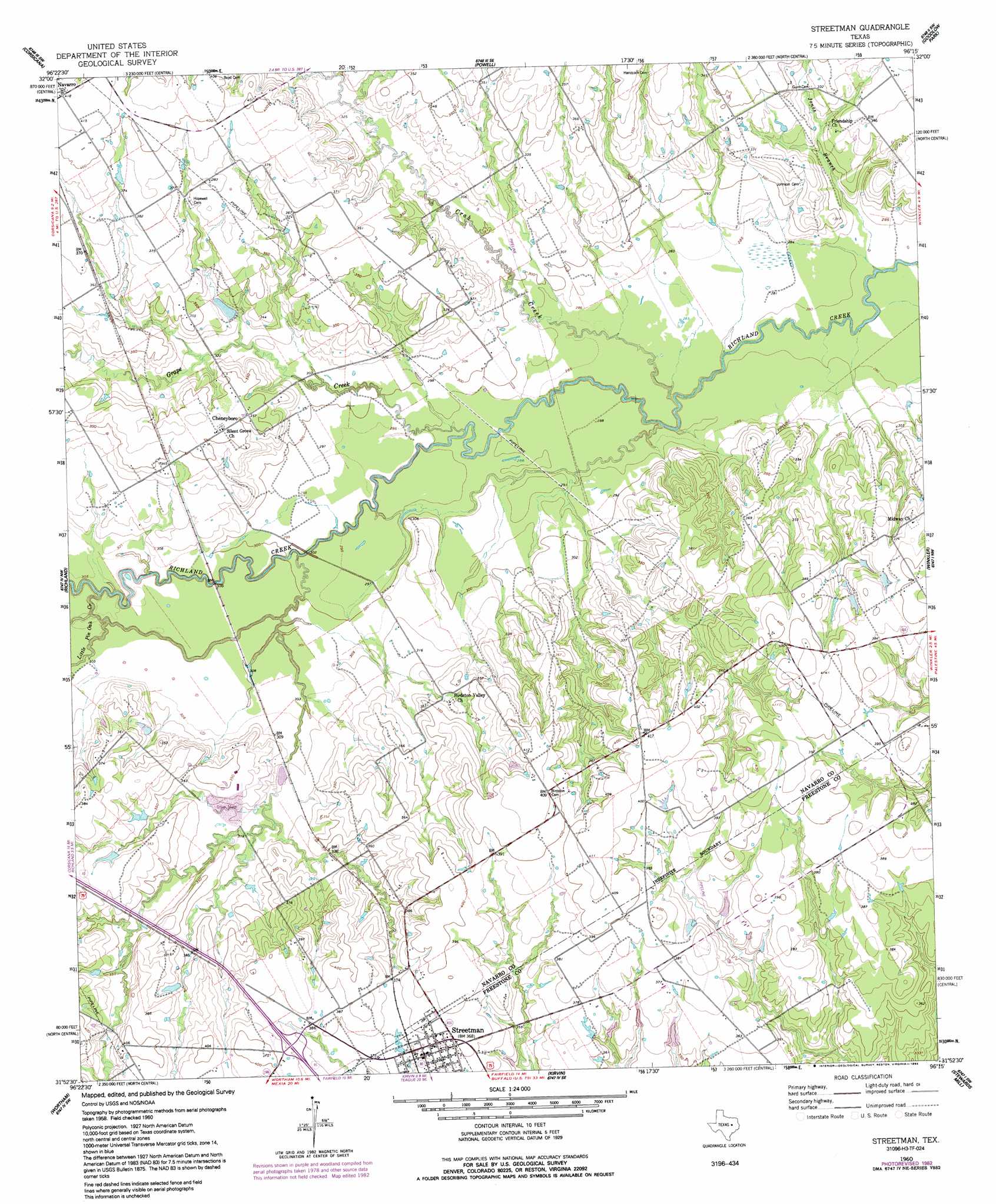
USGS Topo Quad 31096h3 - 1:24,000 scale
| Topo Map Name: | Streetman |
| USGS Topo Quad ID: | 31096h3 |
| Print Size: | ca. 21 1/4" wide x 27" high |
| Southeast Coordinates: | 31.875° N latitude / 96.25° W longitude |
| Map Center Coordinates: | 31.9375° N latitude / 96.3125° W longitude |
| U.S. State: | TX |
| Filename: | o31096h3.jpg |
| Download Map JPG Image: | Streetman topo map 1:24,000 scale |
| Map Type: | Topographic |
| Topo Series: | 7.5´ |
| Map Scale: | 1:24,000 |
| Source of Map Images: | United States Geological Survey (USGS) |
| Alternate Map Versions: |
Streetman TX 1960, updated 1961 Download PDF Buy paper map Streetman TX 1960, updated 1975 Download PDF Buy paper map Streetman TX 1960, updated 1983 Download PDF Buy paper map Streetman TX 1960, updated 1992 Download PDF Buy paper map Streetman TX 2010 Download PDF Buy paper map Streetman TX 2013 Download PDF Buy paper map Streetman TX 2016 Download PDF Buy paper map |
1:24,000 Topo Quads surrounding Streetman
Emhouse |
Chatfield |
Bazette |
Kerens |
Malakoff |
Corbet |
Corsicana |
Powell |
Goodlow Park |
Creslenn Ranch |
Purdon |
Richland |
Streetman |
Winkler |
Roustabout Camp |
Union High |
Wortham |
Kirvin |
Stewards Mill |
Young |
Tehuacana |
Mexia |
Teague North |
Fairfield |
Turlington |
> Back to 31096e1 at 1:100,000 scale
> Back to 31096a1 at 1:250,000 scale
> Back to U.S. Topo Maps home
Streetman topo map: Gazetteer
Streetman: Airports
B T Averheart Airport elevation 120m 393′Byrt Airport elevation 125m 410′
Streetman: Dams
Emerson Dam Number 1 elevation 113m 370′Emerson Dam Number 2 elevation 107m 351′
Texas Industries Levee elevation 94m 308′
Streetman: Populated Places
Cheneyboro elevation 107m 351′Streetman elevation 113m 370′
Streetman: Reservoirs
Emerson Lake Number 1 elevation 113m 370′Emerson Lake Number 2 elevation 107m 351′
Texas Industries Lake elevation 94m 308′
Streetman: Streams
Crab Creek elevation 87m 285′Grape Creek elevation 86m 282′
Jones Branch elevation 82m 269′
Little Pin Oak Creek elevation 86m 282′
Streetman digital topo map on disk
Buy this Streetman topo map showing relief, roads, GPS coordinates and other geographical features, as a high-resolution digital map file on DVD: