Dawson Topo Map Texas
To zoom in, hover over the map of Dawson
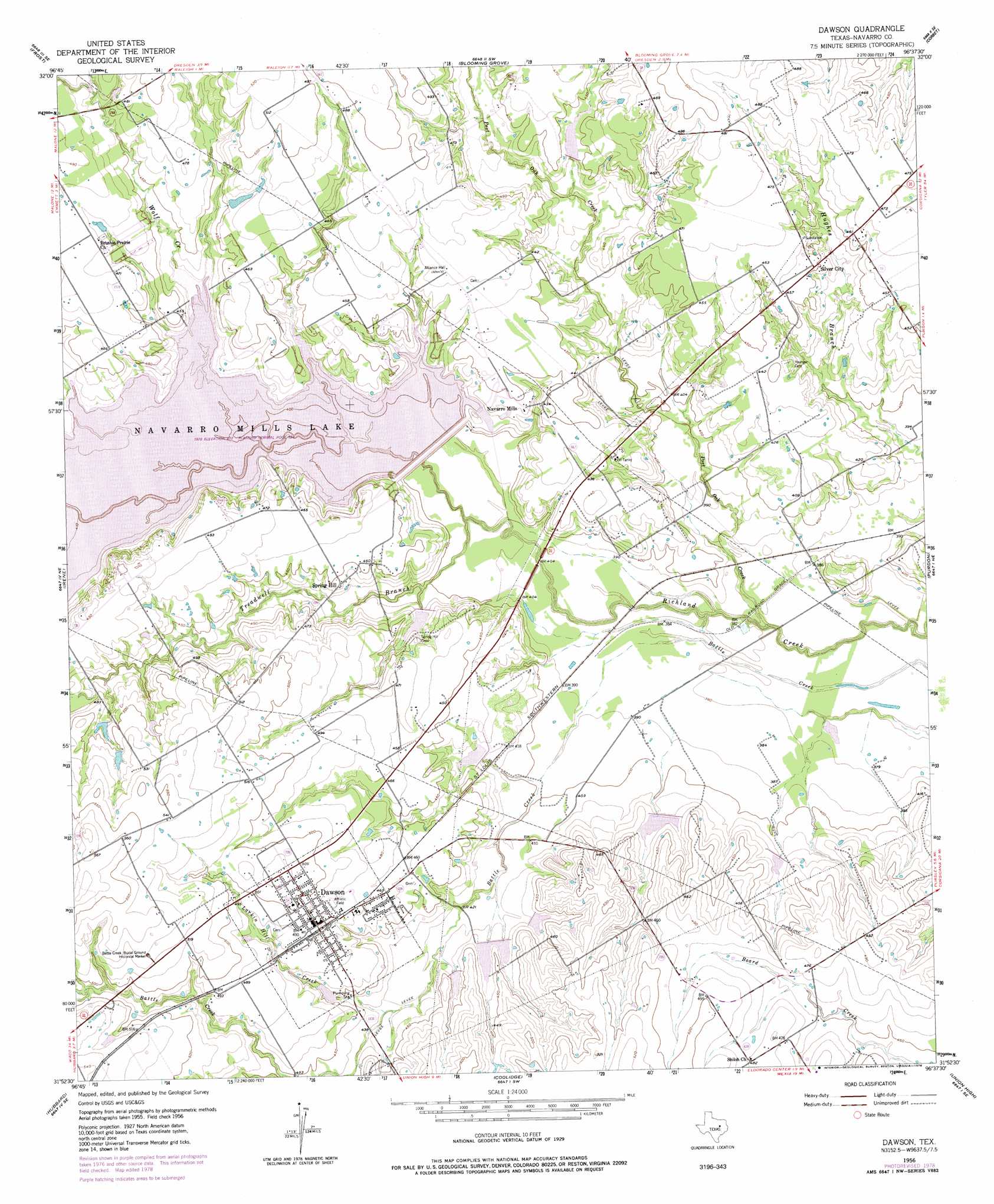
USGS Topo Quad 31096h6 - 1:24,000 scale
| Topo Map Name: | Dawson |
| USGS Topo Quad ID: | 31096h6 |
| Print Size: | ca. 21 1/4" wide x 27" high |
| Southeast Coordinates: | 31.875° N latitude / 96.625° W longitude |
| Map Center Coordinates: | 31.9375° N latitude / 96.6875° W longitude |
| U.S. State: | TX |
| Filename: | o31096h6.jpg |
| Download Map JPG Image: | Dawson topo map 1:24,000 scale |
| Map Type: | Topographic |
| Topo Series: | 7.5´ |
| Map Scale: | 1:24,000 |
| Source of Map Images: | United States Geological Survey (USGS) |
| Alternate Map Versions: |
Dawson TX 1956, updated 1957 Download PDF Buy paper map Dawson TX 1956, updated 1973 Download PDF Buy paper map Dawson TX 2010 Download PDF Buy paper map Dawson TX 2013 Download PDF Buy paper map Dawson TX 2016 Download PDF Buy paper map |
1:24,000 Topo Quads surrounding Dawson
Italy |
Avalon |
Cryer Creek |
Emhouse |
Chatfield |
Mertens |
Frost |
Blooming Grove |
Corbet |
Corsicana |
Malone |
Irene |
Dawson |
Purdon |
Richland |
Penelope |
Hubbard |
Coolidge |
Union High |
Wortham |
Axtell |
Prairie Hill |
Echols |
Tehuacana |
Mexia |
> Back to 31096e1 at 1:100,000 scale
> Back to 31096a1 at 1:250,000 scale
> Back to U.S. Topo Maps home
Dawson topo map: Gazetteer
Dawson: Airports
Hewett-Knapp Airport elevation 139m 456′Dawson: Dams
Lake Dawson Dam elevation 140m 459′Navarro Mills Dam elevation 130m 426′
Soil Conservation Service Site 105 Dam elevation 122m 400′
Soil Conservation Service Site 108 Dam elevation 134m 439′
Soil Conservation Service Site 109 Dam elevation 138m 452′
Soil Conservation Service Site 110 Dam elevation 130m 426′
Soil Conservation Service Site 111 Dam elevation 134m 439′
Soil Conservation Service Site 112 Dam elevation 126m 413′
Soil Conservation Service Site 113 Dam elevation 130m 426′
Soil Conservation Service Site 114 Dam elevation 125m 410′
Soil Conservation Service Site 126 Dam elevation 136m 446′
Soil Conservation Service Site 127 Dam elevation 131m 429′
Dawson: Parks
Battle Creek Burial Ground Historical Marker elevation 160m 524′Liberty Hill Park elevation 121m 396′
Oak Park elevation 135m 442′
Wolf Creek Park elevation 137m 449′
Dawson: Populated Places
Dawson elevation 147m 482′Navarro Mills elevation 133m 436′
Silver City elevation 138m 452′
Spring Hill elevation 134m 439′
Dawson: Reservoirs
Lake Dawson elevation 139m 456′Navarro Mills Lake elevation 130m 426′
Soil Conservation Service Site 105 Reservoir elevation 122m 400′
Soil Conservation Service Site 108 Reservoir elevation 134m 439′
Soil Conservation Service Site 109 Reservoir elevation 138m 452′
Soil Conservation Service Site 110 Reservoir elevation 130m 426′
Soil Conservation Service Site 111 Reservoir elevation 134m 439′
Soil Conservation Service Site 112 Reservoir elevation 126m 413′
Soil Conservation Service Site 113 Reservoir elevation 130m 426′
Soil Conservation Service Site 114 Reservoir elevation 125m 410′
Soil Conservation Service Site 126 Reservoir elevation 136m 446′
Soil Conservation Service Site 127 Reservoir elevation 131m 429′
Dawson: Streams
Larkin Hill Creek elevation 131m 429′Post Oak Creek elevation 110m 360′
Tom Harris Branch elevation 129m 423′
Treadwell Branch elevation 119m 390′
Wolf Creek elevation 129m 423′
Dawson: Trails
Alliance Creek Nature Trail elevation 135m 442′Dawson digital topo map on disk
Buy this Dawson topo map showing relief, roads, GPS coordinates and other geographical features, as a high-resolution digital map file on DVD: