Temple Topo Map Texas
To zoom in, hover over the map of Temple
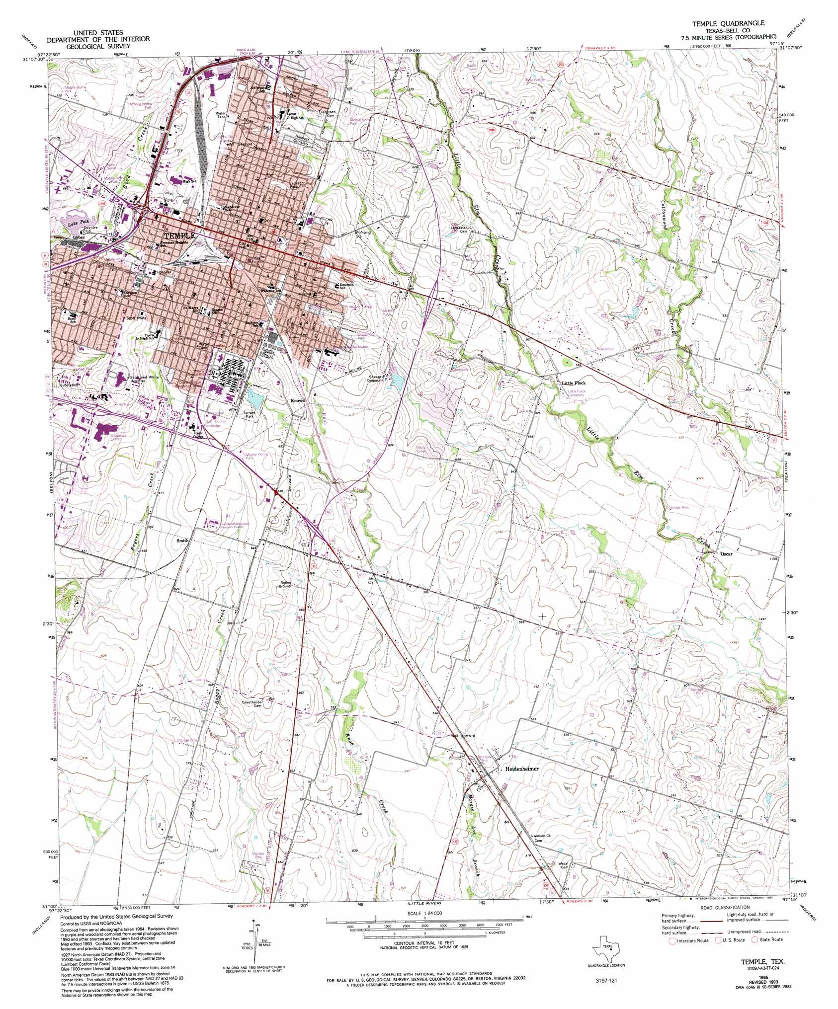
USGS Topo Quad 31097a3 - 1:24,000 scale
| Topo Map Name: | Temple |
| USGS Topo Quad ID: | 31097a3 |
| Print Size: | ca. 21 1/4" wide x 27" high |
| Southeast Coordinates: | 31° N latitude / 97.25° W longitude |
| Map Center Coordinates: | 31.0625° N latitude / 97.3125° W longitude |
| U.S. State: | TX |
| Filename: | o31097a3.jpg |
| Download Map JPG Image: | Temple topo map 1:24,000 scale |
| Map Type: | Topographic |
| Topo Series: | 7.5´ |
| Map Scale: | 1:24,000 |
| Source of Map Images: | United States Geological Survey (USGS) |
| Alternate Map Versions: |
Temple TX 1965, updated 1968 Download PDF Buy paper map Temple TX 1965, updated 1975 Download PDF Buy paper map Temple TX 1965, updated 1993 Download PDF Buy paper map Temple TX 2010 Download PDF Buy paper map Temple TX 2012 Download PDF Buy paper map Temple TX 2016 Download PDF Buy paper map |
1:24,000 Topo Quads surrounding Temple
Leon Junction |
Eagle Springs |
Moody |
Bruceville |
Chilton |
Bland |
Moffat |
Troy |
Belfalls |
Lott |
Nolanville |
Belton |
Temple |
Seaton |
Westphalia |
Salado |
Holland |
Little River |
Rogers |
Yarrelton |
Jarrell |
Bartlett |
Davilla |
Sharp |
Pettibone |
> Back to 31097a1 at 1:100,000 scale
> Back to 31096a1 at 1:250,000 scale
> Back to U.S. Topo Maps home
Temple topo map: Gazetteer
Temple: Airports
Little Elm Field elevation 194m 636′Scott and White Memorial Hospital Heliport elevation 225m 738′
Vac Heliport elevation 218m 715′
Temple: Dams
Country Club Dam elevation 199m 652′Veterans Administration Dam elevation 197m 646′
Temple: Parks
Baker Field elevation 215m 705′Chick Walker Junior Park elevation 214m 702′
Draughon Park elevation 193m 633′
Ferguson Park elevation 202m 662′
Hallford Baseball Field elevation 214m 702′
Jackson Park elevation 210m 688′
James B Wilson Park elevation 197m 646′
James Wilson Park elevation 191m 626′
Jaycee Park elevation 201m 659′
Jefferson Park elevation 230m 754′
Jones Park elevation 215m 705′
Miller Park elevation 210m 688′
Nettles park elevation 225m 738′
Optimist Number 1 Field elevation 228m 748′
Sammons Park elevation 200m 656′
Scott and White Park elevation 205m 672′
Tarrant Park elevation 201m 659′
Temple Jaycee Park elevation 199m 652′
Wildcat Stadium elevation 211m 692′
Woodson Field elevation 223m 731′
Woodson Field elevation 224m 734′
Temple: Populated Places
Gober elevation 204m 669′Heidenheimer elevation 157m 515′
Oscar elevation 153m 501′
Smith elevation 195m 639′
Temple elevation 219m 718′
Temple: Reservoirs
Lake Polk elevation 199m 652′Veterans Administration Lake elevation 197m 646′
Temple: Streams
Williamson Branch elevation 162m 531′Temple digital topo map on disk
Buy this Temple topo map showing relief, roads, GPS coordinates and other geographical features, as a high-resolution digital map file on DVD: