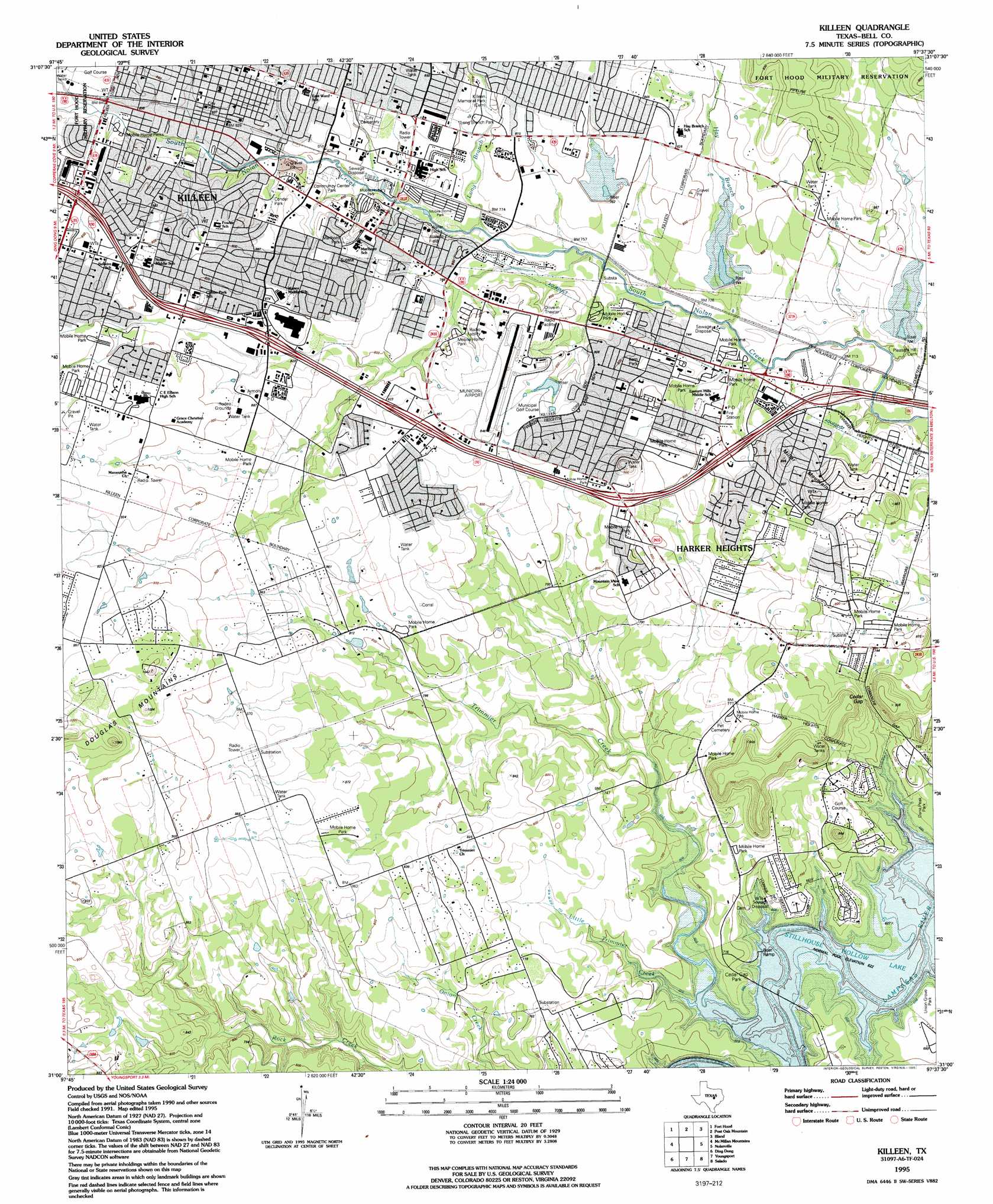
Killeen Topo Map Texas
To zoom in, hover over the map of Killeen
USGS Topo Quad 31097a6 - 1:24,000 scale
| Topo Map Name: | Killeen |
| USGS Topo Quad ID: | 31097a6 |
| Print Size: | ca. 21 1/4" wide x 27" high |
| Southeast Coordinates: | 31° N latitude / 97.625° W longitude |
| Map Center Coordinates: | 31.0625° N latitude / 97.6875° W longitude |
| U.S. State: | TX |
| Filename: | o31097a6.jpg |
| Download Map JPG Image: | Killeen topo map 1:24,000 scale |
| Map Type: | Topographic |
| Topo Series: | 7.5´ |
| Map Scale: | 1:24,000 |
| Source of Map Images: | United States Geological Survey (USGS) |
| Alternate Map Versions: |
Killeen TX 1947, updated 1953 Download PDF Buy paper map Killeen TX 1958, updated 1961 Download PDF Buy paper map Killeen TX 1958, updated 1975 Download PDF Buy paper map Killeen TX 1958, updated 1988 Download PDF Buy paper map Killeen TX 1995, updated 1995 Download PDF Buy paper map Killeen TX 2010 Download PDF Buy paper map Killeen TX 2012 Download PDF Buy paper map Killeen TX 2016 Download PDF Buy paper map |
1:24,000 Topo Quads surrounding Killeen
Pidcoke |
Shell Mountains |
North Fort Hood |
Leon Junction |
Eagle Springs |
Twin Mountains |
Fort Hood |
Post Oak Mountain |
Bland |
Moffat |
Copperas Cove |
Mcmillan Mountains |
Killeen |
Nolanville |
Belton |
Briggs |
Ding Dong |
Youngsport |
Salado |
Holland |
Mahomet |
Florence |
Cobbs Cavern |
Jarrell |
Bartlett |
> Back to 31097a1 at 1:100,000 scale
> Back to 31096a1 at 1:250,000 scale
> Back to U.S. Topo Maps home
Killeen topo map: Gazetteer
Killeen: Airports
Killeen Municipal Airport elevation 256m 839′Killeen: Dams
City of Killeen Dam elevation 245m 803′Soil Conservation Service Site 7 Dam elevation 236m 774′
Soil Conservation Service Site 8 Dam elevation 226m 741′
Soil Conservation Service Site 9 Dam elevation 213m 698′
Killeen: Gaps
Cedar Gap elevation 215m 705′Killeen: Parks
Cedar Gap Park elevation 207m 679′Community Center Park elevation 244m 800′
Conder Park elevation 259m 849′
Cox Park elevation 239m 784′
Jefferies Park elevation 256m 839′
Kern Park elevation 237m 777′
Long Branch Park elevation 241m 790′
Long Branch Park elevation 250m 820′
Marlboro Park elevation 255m 836′
Killeen: Populated Places
Harker Heights elevation 233m 764′Killeen elevation 252m 826′
Lone Star elevation 255m 836′
Killeen: Reservoirs
City of Killeen Reservoir elevation 245m 803′Soil Conservation Service Site 7 Reservoir elevation 236m 774′
Soil Conservation Service Site 8 Reservoir elevation 226m 741′
Soil Conservation Service Site 9 Reservoir elevation 213m 698′
Killeen: Streams
Hay Branch elevation 219m 718′Little Trimmier Creek elevation 200m 656′
Long Branch elevation 231m 757′
Trimmier Creek elevation 190m 623′
Killeen: Summits
Douglas Mountains elevation 315m 1033′Miller Mountain elevation 276m 905′
Killeen digital topo map on disk
Buy this Killeen topo map showing relief, roads, GPS coordinates and other geographical features, as a high-resolution digital map file on DVD: