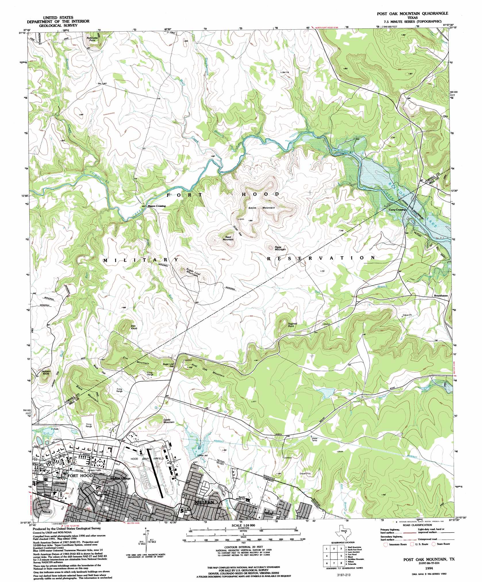
Post Oak Mountain Topo Map Texas
To zoom in, hover over the map of Post Oak Mountain
USGS Topo Quad 31097b6 - 1:24,000 scale
| Topo Map Name: | Post Oak Mountain |
| USGS Topo Quad ID: | 31097b6 |
| Print Size: | ca. 21 1/4" wide x 27" high |
| Southeast Coordinates: | 31.125° N latitude / 97.625° W longitude |
| Map Center Coordinates: | 31.1875° N latitude / 97.6875° W longitude |
| U.S. State: | TX |
| Filename: | o31097b6.jpg |
| Download Map JPG Image: | Post Oak Mountain topo map 1:24,000 scale |
| Map Type: | Topographic |
| Topo Series: | 7.5´ |
| Map Scale: | 1:24,000 |
| Source of Map Images: | United States Geological Survey (USGS) |
| Alternate Map Versions: |
Post Oak Mountain TX 1947, updated 1953 Download PDF Buy paper map Post Oak Mountain TX 1958, updated 1961 Download PDF Buy paper map Post Oak Mountain TX 1958, updated 1979 Download PDF Buy paper map Post Oak Mountain TX 1994, updated 1995 Download PDF Buy paper map Post Oak Mountain TX 2010 Download PDF Buy paper map Post Oak Mountain TX 2012 Download PDF Buy paper map Post Oak Mountain TX 2016 Download PDF Buy paper map |
1:24,000 Topo Quads surrounding Post Oak Mountain
Purmela |
Gatesville West |
Gatesville East |
Oglesby |
Mcgregor |
Pidcoke |
Shell Mountains |
North Fort Hood |
Leon Junction |
Eagle Springs |
Twin Mountains |
Fort Hood |
Post Oak Mountain |
Bland |
Moffat |
Copperas Cove |
Mcmillan Mountains |
Killeen |
Nolanville |
Belton |
Briggs |
Ding Dong |
Youngsport |
Salado |
Holland |
> Back to 31097a1 at 1:100,000 scale
> Back to 31096a1 at 1:250,000 scale
> Back to U.S. Topo Maps home
Post Oak Mountain topo map: Gazetteer
Post Oak Mountain: Airports
Hood Army Air Field elevation 274m 898′Post Oak Mountain: Dams
Engineer Lake Dam elevation 275m 902′Soil Conservation Service Site 5a Dam elevation 262m 859′
Tank Wash Dam elevation 262m 859′
Post Oak Mountain: Gaps
Black Gap elevation 263m 862′Gulps Gap elevation 261m 856′
Jackson Gap elevation 253m 830′
Sugar Loaf Gap elevation 272m 892′
Post Oak Mountain: Populated Places
Brookhaven elevation 214m 702′Curry Crossing elevation 181m 593′
Mason Crossing elevation 193m 633′
Riggs Ford elevation 182m 597′
Walker Village elevation 274m 898′
Post Oak Mountain: Reservoirs
Engineer Lake elevation 275m 902′Soil Conservation Service Site 5a Reservoir elevation 262m 859′
Tank Wash Lake elevation 262m 859′
Post Oak Mountain: Streams
Browns Creek elevation 196m 643′Bull Run elevation 195m 639′
Riggs Run elevation 198m 649′
Stephenson Branch elevation 193m 633′
Wolf Creek elevation 189m 620′
Post Oak Mountain: Summits
Black Mountain elevation 319m 1046′Castle Mountain elevation 301m 987′
Elm Knob elevation 307m 1007′
Elm Mountain elevation 312m 1023′
Jackson Knob elevation 319m 1046′
Post Oak Mountain elevation 307m 1007′
Reed Mountain elevation 295m 967′
Riggs Mountain elevation 274m 898′
Smith Mountain elevation 301m 987′
Sugar Loaf Mountain elevation 283m 928′
Trapnell Point elevation 291m 954′
Post Oak Mountain: Valleys
Egypt Hollow elevation 189m 620′Post Oak Mountain digital topo map on disk
Buy this Post Oak Mountain topo map showing relief, roads, GPS coordinates and other geographical features, as a high-resolution digital map file on DVD: