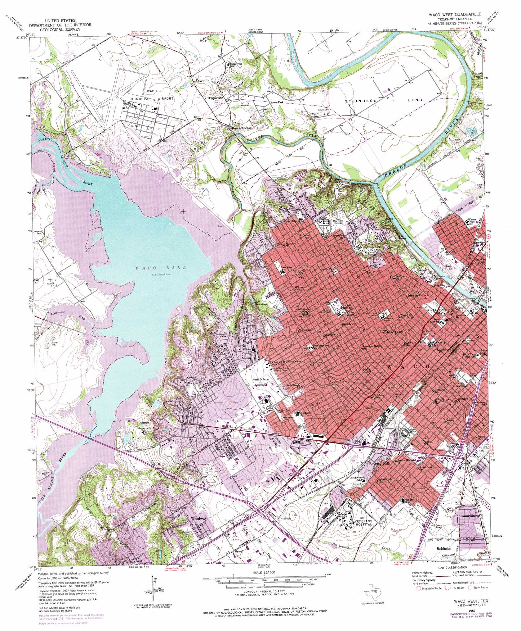
Waco West Topo Map Texas
To zoom in, hover over the map of Waco West
USGS Topo Quad 31097e2 - 1:24,000 scale
| Topo Map Name: | Waco West |
| USGS Topo Quad ID: | 31097e2 |
| Print Size: | ca. 21 1/4" wide x 27" high |
| Southeast Coordinates: | 31.5° N latitude / 97.125° W longitude |
| Map Center Coordinates: | 31.5625° N latitude / 97.1875° W longitude |
| U.S. State: | TX |
| Filename: | o31097e2.jpg |
| Download Map JPG Image: | Waco West topo map 1:24,000 scale |
| Map Type: | Topographic |
| Topo Series: | 7.5´ |
| Map Scale: | 1:24,000 |
| Source of Map Images: | United States Geological Survey (USGS) |
| Alternate Map Versions: |
Waco West TX 1957, updated 1958 Download PDF Buy paper map Waco West TX 1957, updated 1971 Download PDF Buy paper map Waco West TX 1957, updated 1977 Download PDF Buy paper map Waco West TX 2010 Download PDF Buy paper map Waco West TX 2012 Download PDF Buy paper map Waco West TX 2016 Download PDF Buy paper map |
1:24,000 Topo Quads surrounding Waco West
Laguna Park |
Smiths Bend |
Aquilla |
West |
Penelope |
Valley Mills |
China Springs |
Gholson |
Elm Mott |
Axtell |
Crawford |
Speegleville |
Waco West |
Waco East |
Elk |
Mcgregor |
South Bosque |
Lorena |
Robinson |
Riesel |
Eagle Springs |
Moody |
Bruceville |
Chilton |
Marlin |
> Back to 31097e1 at 1:100,000 scale
> Back to 31096a1 at 1:250,000 scale
> Back to U.S. Topo Maps home
Waco West topo map: Gazetteer
Waco West: Airports
Hillcrest Baptist Medical Center Heliport elevation 168m 551′Providence Health Center Heliport elevation 186m 610′
Waco Regional Airport elevation 154m 505′
Waco West: Bends
Steinbeck Bend elevation 124m 406′Waco West: Bridges
Waco Suspension Bridge elevation 119m 390′Washington Avenue Bridge elevation 110m 360′
Waco West: Cliffs
Emmons Cliff elevation 112m 367′Lawson Point elevation 142m 465′
Lovers Leap elevation 112m 367′
Waco West: Dams
Waco Dam elevation 147m 482′Waco West: Parks
Airport Park elevation 149m 488′Alta Vista Park elevation 143m 469′
Baylor Ball Park elevation 124m 406′
Baylor Stadium elevation 154m 505′
Bledsoe Miller Park elevation 116m 380′
Bosque Park elevation 122m 400′
Cameron Park elevation 148m 485′
Cougar Field - Reicher Catholic School elevation 166m 544′
Crestview Park elevation 177m 580′
Doris D Miller Park elevation 117m 383′
Dripping Spring Park elevation 127m 416′
Floyd Casey Stadium elevation 154m 505′
Getterman Stadium elevation 126m 413′
Hart-Patterson Track and Field Complex elevation 145m 475′
Heart O Texas Coliseum elevation 180m 590′
Jacee Park elevation 190m 623′
Kathy Ball Park elevation 126m 413′
Kendrick Park elevation 161m 528′
Kiwanis Field elevation 126m 413′
Koehne Park elevation 144m 472′
Midway Little League Broughton Field elevation 194m 636′
Pacer Field elevation 157m 515′
Speegleville Park elevation 150m 492′
Stars Stadium elevation 157m 515′
Viking Hills Park elevation 187m 613′
Waco Independent School District Stadium elevation 163m 534′
Waco Municipal Stadium elevation 126m 413′
Waco West: Populated Places
Bannas Junction elevation 135m 442′Beverly elevation 148m 485′
Beverly Hills elevation 161m 528′
Bosqueville elevation 138m 452′
Jewell elevation 184m 603′
Waco elevation 143m 469′
Woodway elevation 193m 633′
Waco West: Reservoirs
Lake Robinhood elevation 150m 492′Waco Lake elevation 129m 423′
Waco West: Springs
Waco Springs (historical) elevation 119m 390′Waco West: Streams
Bosque River elevation 112m 367′Davis Branch elevation 139m 456′
Keys Branch elevation 117m 383′
Landon Branch elevation 139m 456′
North Bosque River elevation 139m 456′
South Bosque River elevation 139m 456′
Speegleville Creek elevation 139m 456′
Tennant Branch elevation 139m 456′
White Rock Creek elevation 113m 370′
Waco West: Trails
Cameron Park Hike and Bike Trail elevation 140m 459′Waco West digital topo map on disk
Buy this Waco West topo map showing relief, roads, GPS coordinates and other geographical features, as a high-resolution digital map file on DVD: