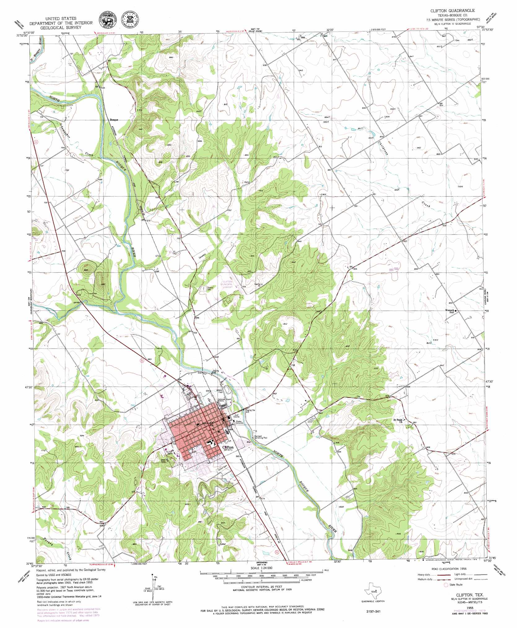
Clifton Topo Map Texas
To zoom in, hover over the map of Clifton
USGS Topo Quad 31097g5 - 1:24,000 scale
| Topo Map Name: | Clifton |
| USGS Topo Quad ID: | 31097g5 |
| Print Size: | ca. 21 1/4" wide x 27" high |
| Southeast Coordinates: | 31.75° N latitude / 97.5° W longitude |
| Map Center Coordinates: | 31.8125° N latitude / 97.5625° W longitude |
| U.S. State: | TX |
| Filename: | o31097g5.jpg |
| Download Map JPG Image: | Clifton topo map 1:24,000 scale |
| Map Type: | Topographic |
| Topo Series: | 7.5´ |
| Map Scale: | 1:24,000 |
| Source of Map Images: | United States Geological Survey (USGS) |
| Alternate Map Versions: |
Clifton TX 1955, updated 1956 Download PDF Buy paper map Clifton TX 1955, updated 1979 Download PDF Buy paper map Clifton TX 2010 Download PDF Buy paper map Clifton TX 2012 Download PDF Buy paper map Clifton TX 2016 Download PDF Buy paper map |
1:24,000 Topo Quads surrounding Clifton
Walnut Springs West |
Walnut Springs East |
Morgan |
Lakeside Village |
Blanton |
Iredell |
Meridian |
Pilot Knob |
Allen Bend |
Whitney |
Cranfills Gap |
Sugarloaf Mountain |
Clifton |
Laguna Park |
Smiths Bend |
German Valley |
Hurst Spring |
Mosheim |
Valley Mills |
China Springs |
Ater |
Turnersville |
Coryell |
Crawford |
Speegleville |
> Back to 31097e1 at 1:100,000 scale
> Back to 31096a1 at 1:250,000 scale
> Back to U.S. Topo Maps home
Clifton topo map: Gazetteer
Clifton: Airports
Clifton Municipal/Eisenhower Field elevation 240m 787′Clifton: Dams
Old Mill Dam elevation 189m 620′Olsen Lake Dam elevation 195m 639′
Clifton: Parks
Cub Stadium elevation 215m 705′Clifton: Populated Places
Bosque elevation 208m 682′Clifton elevation 205m 672′
Clifton: Reservoirs
Old Mill Lake elevation 189m 620′Olsen Lake elevation 195m 639′
Clifton: Streams
Meridian Creek elevation 194m 636′Schumacher Creek elevation 200m 656′
Clifton digital topo map on disk
Buy this Clifton topo map showing relief, roads, GPS coordinates and other geographical features, as a high-resolution digital map file on DVD: