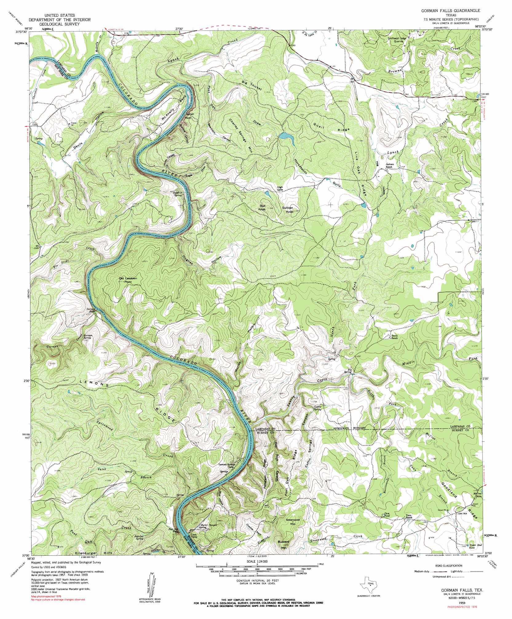
Gorman Falls Topo Map Texas
To zoom in, hover over the map of Gorman Falls
USGS Topo Quad 31098a4 - 1:24,000 scale
| Topo Map Name: | Gorman Falls |
| USGS Topo Quad ID: | 31098a4 |
| Print Size: | ca. 21 1/4" wide x 27" high |
| Southeast Coordinates: | 31° N latitude / 98.375° W longitude |
| Map Center Coordinates: | 31.0625° N latitude / 98.4375° W longitude |
| U.S. State: | TX |
| Filename: | o31098a4.jpg |
| Download Map JPG Image: | Gorman Falls topo map 1:24,000 scale |
| Map Type: | Topographic |
| Topo Series: | 7.5´ |
| Map Scale: | 1:24,000 |
| Source of Map Images: | United States Geological Survey (USGS) |
| Alternate Map Versions: |
Gorman Falls TX 1959 Download PDF Buy paper map Gorman Falls TX 1959, updated 1960 Download PDF Buy paper map Gorman Falls TX 1959, updated 1990 Download PDF Buy paper map Gorman Falls TX 2010 Download PDF Buy paper map Gorman Falls TX 2013 Download PDF Buy paper map Gorman Falls TX 2016 Download PDF Buy paper map |
1:24,000 Topo Quads surrounding Gorman Falls
Big Valley South |
San Saba Peak |
Antelope Gap |
Castle Peak |
Adamsville |
San Saba |
Wolf Ridge |
Lometa |
Ogles |
Flat Top Peak |
Bear Hollow |
Bend |
Gorman Falls |
Nix |
Lampasas |
Cherokee |
Indian Hills |
Tow |
Naruna |
Lake Victor |
Llano North |
Lone Grove |
Lake Buchanan |
Council Creek |
Burnet |
> Back to 31098a1 at 1:100,000 scale
> Back to 31098a1 at 1:250,000 scale
> Back to U.S. Topo Maps home
Gorman Falls topo map: Gazetteer
Gorman Falls: Cliffs
Indian Point elevation 356m 1167′Gorman Falls: Falls
Gorman Falls elevation 336m 1102′Post Oak Falls elevation 327m 1072′
Gorman Falls: Gaps
High Gate elevation 403m 1322′Gorman Falls: Lakes
Cave Pond elevation 427m 1400′Gorman Falls: Mines
Southwest Ledge Quarries elevation 389m 1276′Gorman Falls: Parks
Colorado Bend State Park elevation 408m 1338′Gorman Falls: Reservoirs
McCrea Tank elevation 421m 1381′Upper End Tank elevation 440m 1443′
Gorman Falls: Ridges
Goodland Ridge elevation 425m 1394′Lemons Ridge elevation 410m 1345′
Live Oak Ridge elevation 410m 1345′
Patterson Ridge elevation 398m 1305′
Post Oak Ridge elevation 414m 1358′
Quail Ridge elevation 410m 1345′
Gorman Falls: Springs
Big Spring elevation 359m 1177′Burnt Canyon Spring elevation 339m 1112′
Coffin Spring elevation 348m 1141′
Gorman Spring elevation 351m 1151′
Patterson Springs elevation 414m 1358′
Post Oak Spring elevation 379m 1243′
Sulphur Spring elevation 319m 1046′
Gorman Falls: Streams
Cherokee Creek elevation 323m 1059′Gorman Creek elevation 317m 1040′
Jennings Creek elevation 376m 1233′
Lynch Creek elevation 322m 1056′
Lynch Creek elevation 365m 1197′
McAnelly Creek elevation 323m 1059′
McCrea Branch elevation 387m 1269′
Middle Fork Yancey Creek elevation 353m 1158′
North Fork Yancey Creek elevation 331m 1085′
Post Oak Creek elevation 315m 1033′
Rattlesnake Branch elevation 387m 1269′
South Fork Yancy Creek elevation 353m 1158′
Spicewood Creek elevation 317m 1040′
Tie Slide Creek elevation 317m 1040′
Vann Branch elevation 398m 1305′
Yancey Creek elevation 316m 1036′
Yates Branch elevation 338m 1108′
Gorman Falls: Summits
Bull Knob elevation 406m 1332′Buzzard Mountain elevation 443m 1453′
Charley Springs Mountain elevation 417m 1368′
Greenwood Mountain elevation 427m 1400′
Old Letdown Point elevation 399m 1309′
Sullivan Knob elevation 434m 1423′
Gorman Falls: Trails
Colorado Bend State Park Trail elevation 327m 1072′Gorman Falls: Valleys
Beartrack Canyon elevation 356m 1167′Brahma Canyon elevation 329m 1079′
Coffin Springs Canyon elevation 327m 1072′
Cracker Neck elevation 371m 1217′
Devils Hollow elevation 320m 1049′
Eagle Draw elevation 328m 1076′
Hog Hollow elevation 378m 1240′
Horsetooth Gully elevation 390m 1279′
Hughes Hollow elevation 332m 1089′
Hurley Hollow elevation 332m 1089′
Post Oak Draw elevation 330m 1082′
Red Rock Canyon elevation 322m 1056′
Windy Canyon elevation 323m 1059′
Wolf Hollow elevation 316m 1036′
Gorman Falls: Woods
Big Thicket elevation 393m 1289′Gorman Falls digital topo map on disk
Buy this Gorman Falls topo map showing relief, roads, GPS coordinates and other geographical features, as a high-resolution digital map file on DVD: