Lometa Topo Map Texas
To zoom in, hover over the map of Lometa
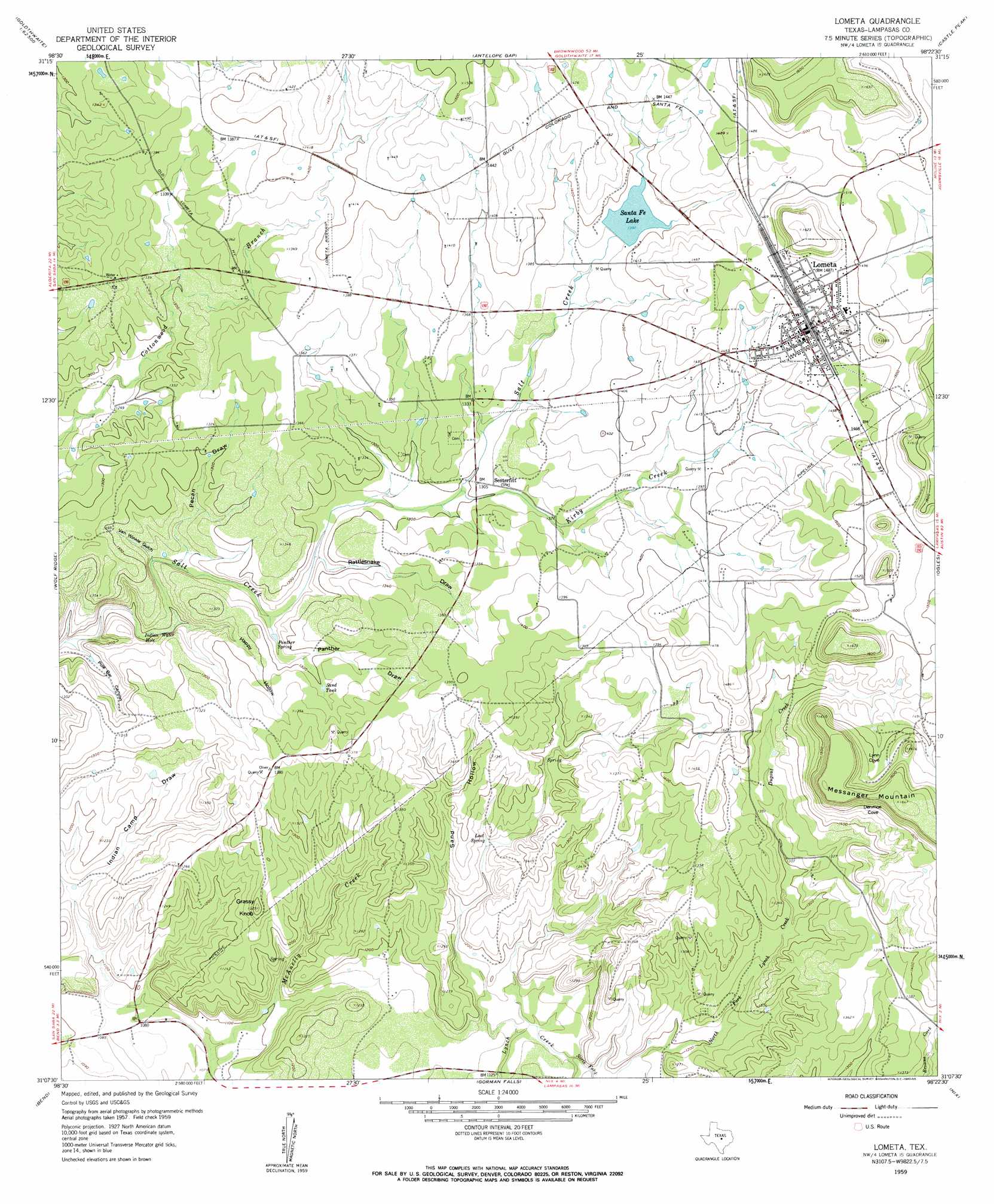
USGS Topo Quad 31098b4 - 1:24,000 scale
| Topo Map Name: | Lometa |
| USGS Topo Quad ID: | 31098b4 |
| Print Size: | ca. 21 1/4" wide x 27" high |
| Southeast Coordinates: | 31.125° N latitude / 98.375° W longitude |
| Map Center Coordinates: | 31.1875° N latitude / 98.4375° W longitude |
| U.S. State: | TX |
| Filename: | o31098b4.jpg |
| Download Map JPG Image: | Lometa topo map 1:24,000 scale |
| Map Type: | Topographic |
| Topo Series: | 7.5´ |
| Map Scale: | 1:24,000 |
| Source of Map Images: | United States Geological Survey (USGS) |
| Alternate Map Versions: |
Lometa TX 1959, updated 1960 Download PDF Buy paper map Lometa TX 2010 Download PDF Buy paper map Lometa TX 2012 Download PDF Buy paper map Lometa TX 2016 Download PDF Buy paper map |
1:24,000 Topo Quads surrounding Lometa
Big Valley North |
Goldthwaite |
Center City |
Star |
Evant |
Big Valley South |
San Saba Peak |
Antelope Gap |
Castle Peak |
Adamsville |
San Saba |
Wolf Ridge |
Lometa |
Ogles |
Flat Top Peak |
Bear Hollow |
Bend |
Gorman Falls |
Nix |
Lampasas |
Cherokee |
Indian Hills |
Tow |
Naruna |
Lake Victor |
> Back to 31098a1 at 1:100,000 scale
> Back to 31098a1 at 1:250,000 scale
> Back to U.S. Topo Maps home
Lometa topo map: Gazetteer
Lometa: Airports
Lometa Air Strip elevation 421m 1381′Lometa: Basins
Denmoe Cove elevation 445m 1459′Lometa: Dams
Lometa Reservoir Dam elevation 421m 1381′Lometa: Lakes
Indian Water Hole elevation 362m 1187′Lometa: Populated Places
Lometa elevation 455m 1492′Senterfitt elevation 400m 1312′
Senterfitt (historical) elevation 402m 1318′
Lometa: Reservoirs
Lometa Reservoir elevation 421m 1381′Sand Tank elevation 402m 1318′
Santa Fe Lake elevation 421m 1381′
Lometa: Springs
Jennings Springs elevation 403m 1322′Lost Spring elevation 380m 1246′
Panther Spring elevation 385m 1263′
Lometa: Streams
Browns Creek elevation 347m 1138′Dugout Creek elevation 394m 1292′
Kirby Creek elevation 396m 1299′
North Fork Lynch Creek elevation 355m 1164′
Lometa: Summits
Grassy Knob elevation 397m 1302′Messanger Mountain elevation 502m 1646′
Lometa: Valleys
Happy Hollow elevation 369m 1210′Indian Camp Draw elevation 343m 1125′
Lynn Cove elevation 438m 1437′
Panther Draw elevation 382m 1253′
Pecan Draw elevation 372m 1220′
Pole Bar Canyon elevation 352m 1154′
Rattlesnake Draw elevation 386m 1266′
Sand Hollow elevation 361m 1184′
Van Winkle Gulch elevation 370m 1213′
Lometa digital topo map on disk
Buy this Lometa topo map showing relief, roads, GPS coordinates and other geographical features, as a high-resolution digital map file on DVD: