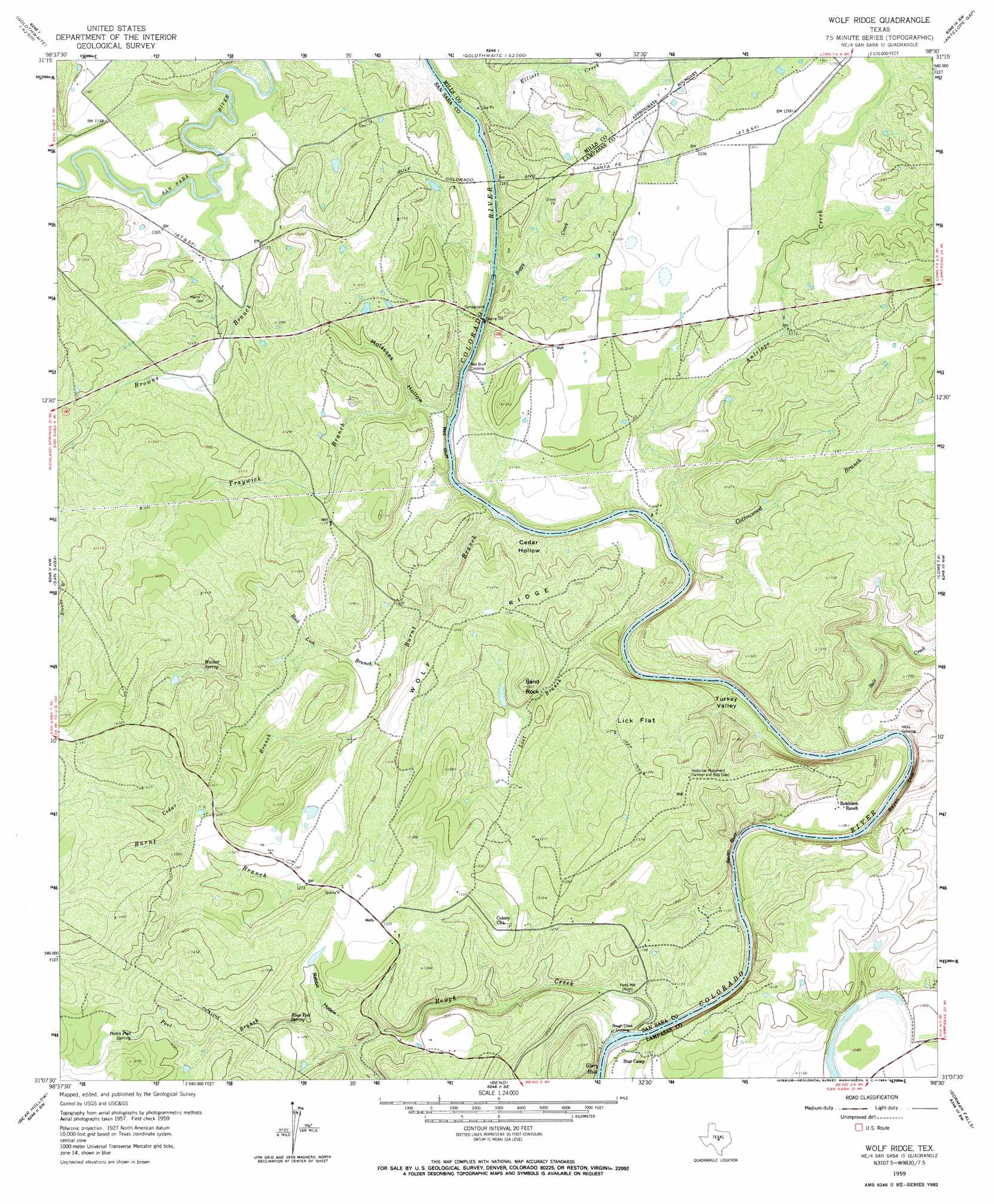
Wolf Ridge Topo Map Texas
To zoom in, hover over the map of Wolf Ridge
USGS Topo Quad 31098b5 - 1:24,000 scale
| Topo Map Name: | Wolf Ridge |
| USGS Topo Quad ID: | 31098b5 |
| Print Size: | ca. 21 1/4" wide x 27" high |
| Southeast Coordinates: | 31.125° N latitude / 98.5° W longitude |
| Map Center Coordinates: | 31.1875° N latitude / 98.5625° W longitude |
| U.S. State: | TX |
| Filename: | o31098b5.jpg |
| Download Map JPG Image: | Wolf Ridge topo map 1:24,000 scale |
| Map Type: | Topographic |
| Topo Series: | 7.5´ |
| Map Scale: | 1:24,000 |
| Source of Map Images: | United States Geological Survey (USGS) |
| Alternate Map Versions: |
Wolf Ridge TX 1959, updated 1960 Download PDF Buy paper map Wolf Ridge TX 1959, updated 1964 Download PDF Buy paper map Wolf Ridge TX 2010 Download PDF Buy paper map Wolf Ridge TX 2012 Download PDF Buy paper map Wolf Ridge TX 2016 Download PDF Buy paper map |
1:24,000 Topo Quads surrounding Wolf Ridge
Regency |
Big Valley North |
Goldthwaite |
Center City |
Star |
Blucher Mountain |
Big Valley South |
San Saba Peak |
Antelope Gap |
Castle Peak |
Algerita |
San Saba |
Wolf Ridge |
Lometa |
Ogles |
Buffalo Knob |
Bear Hollow |
Bend |
Gorman Falls |
Nix |
Magill Mountain |
Cherokee |
Indian Hills |
Tow |
Naruna |
> Back to 31098a1 at 1:100,000 scale
> Back to 31098a1 at 1:250,000 scale
> Back to U.S. Topo Maps home
Wolf Ridge topo map: Gazetteer
Wolf Ridge: Basins
Cedar Hollow elevation 357m 1171′Turkey Valley elevation 348m 1141′
Wolf Ridge: Bridges
US 190 Bridge elevation 341m 1118′Wolf Ridge: Cliffs
Raven Bluff elevation 326m 1069′Raven Cliff elevation 390m 1279′
Red Bluff elevation 335m 1099′
Wolf Ridge: Flats
Lick Flat elevation 385m 1263′Wolf Ridge: Lakes
Glory Hole elevation 325m 1066′Wolf Ridge: Parks
Historical Monument elevation 412m 1351′Wolf Ridge: Populated Places
Hicks Crossing elevation 334m 1095′Red Bluff Crossing elevation 345m 1131′
Rough Creek Crossing elevation 325m 1066′
Wolf Ridge: Ridges
Wolf Ridge elevation 381m 1250′Wolf Ridge: Springs
Blue Pool Spring elevation 384m 1259′Parker Springs elevation 425m 1394′
Pecan Pool Spring elevation 426m 1397′
Walker Spring elevation 408m 1338′
Wolf Ridge: Streams
Antelope Creek elevation 335m 1099′Boggy Creek elevation 343m 1125′
Browns Branch elevation 347m 1138′
Burnt Branch elevation 335m 1099′
Cedar Branch elevation 364m 1194′
Cottonwood Branch elevation 341m 1118′
Elliott Creek elevation 341m 1118′
Lost Branch elevation 335m 1099′
Pool Branch elevation 371m 1217′
Rock Lick Branch elevation 352m 1154′
Rough Creek elevation 326m 1069′
Salt Creek elevation 335m 1099′
Traywick Branch elevation 335m 1099′
Wolf Ridge: Summits
Sand Rock elevation 399m 1309′Wolf Ridge: Valleys
Molasses Hollow elevation 335m 1099′Rabbit Hollow elevation 376m 1233′
Wolf Ridge digital topo map on disk
Buy this Wolf Ridge topo map showing relief, roads, GPS coordinates and other geographical features, as a high-resolution digital map file on DVD: