Antelope Gap Topo Map Texas
To zoom in, hover over the map of Antelope Gap
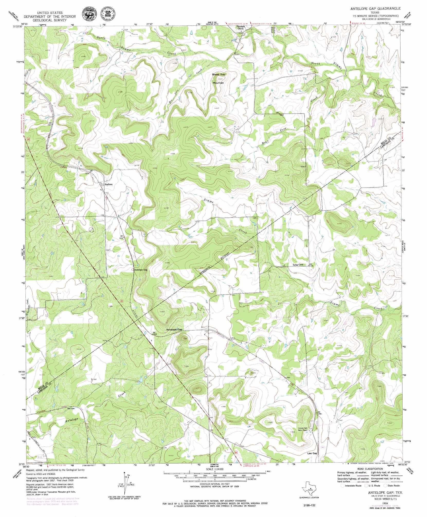
USGS Topo Quad 31098c4 - 1:24,000 scale
| Topo Map Name: | Antelope Gap |
| USGS Topo Quad ID: | 31098c4 |
| Print Size: | ca. 21 1/4" wide x 27" high |
| Southeast Coordinates: | 31.25° N latitude / 98.375° W longitude |
| Map Center Coordinates: | 31.3125° N latitude / 98.4375° W longitude |
| U.S. State: | TX |
| Filename: | o31098c4.jpg |
| Download Map JPG Image: | Antelope Gap topo map 1:24,000 scale |
| Map Type: | Topographic |
| Topo Series: | 7.5´ |
| Map Scale: | 1:24,000 |
| Source of Map Images: | United States Geological Survey (USGS) |
| Alternate Map Versions: |
Antelope Gap TX 1959, updated 1960 Download PDF Buy paper map Antelope Gap TX 2010 Download PDF Buy paper map Antelope Gap TX 2012 Download PDF Buy paper map Antelope Gap TX 2016 Download PDF Buy paper map |
1:24,000 Topo Quads surrounding Antelope Gap
Mullin |
Lake Merritt |
Caradan |
Pecan Wells |
Shive |
Big Valley North |
Goldthwaite |
Center City |
Star |
Evant |
Big Valley South |
San Saba Peak |
Antelope Gap |
Castle Peak |
Adamsville |
San Saba |
Wolf Ridge |
Lometa |
Ogles |
Flat Top Peak |
Bear Hollow |
Bend |
Gorman Falls |
Nix |
Lampasas |
> Back to 31098a1 at 1:100,000 scale
> Back to 31098a1 at 1:250,000 scale
> Back to U.S. Topo Maps home
Antelope Gap topo map: Gazetteer
Antelope Gap: Dams
Clift Lake Dam elevation 405m 1328′Antelope Gap: Gaps
Antelope Gap elevation 445m 1459′Lee Gap elevation 460m 1509′
Antelope Gap: Populated Places
Pleasant Grove elevation 433m 1420′Scallorn elevation 466m 1528′
Antelope Gap: Reservoirs
Clift Lake elevation 405m 1328′Antelope Gap: Streams
Bear Cove Creek elevation 403m 1322′Bee Cove Creek elevation 429m 1407′
Nesbitt Branch elevation 411m 1348′
Antelope Gap: Summits
Bread Tray Mountain elevation 504m 1653′Antelope Gap digital topo map on disk
Buy this Antelope Gap topo map showing relief, roads, GPS coordinates and other geographical features, as a high-resolution digital map file on DVD: