Center City Topo Map Texas
To zoom in, hover over the map of Center City
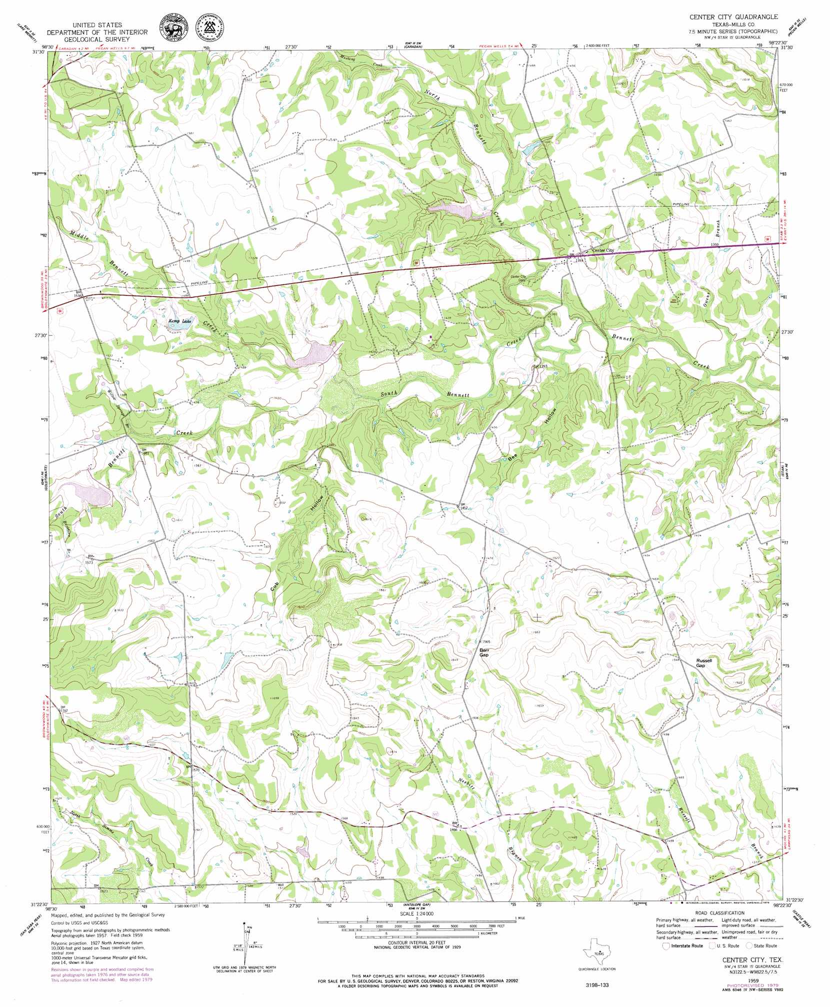
USGS Topo Quad 31098d4 - 1:24,000 scale
| Topo Map Name: | Center City |
| USGS Topo Quad ID: | 31098d4 |
| Print Size: | ca. 21 1/4" wide x 27" high |
| Southeast Coordinates: | 31.375° N latitude / 98.375° W longitude |
| Map Center Coordinates: | 31.4375° N latitude / 98.4375° W longitude |
| U.S. State: | TX |
| Filename: | o31098d4.jpg |
| Download Map JPG Image: | Center City topo map 1:24,000 scale |
| Map Type: | Topographic |
| Topo Series: | 7.5´ |
| Map Scale: | 1:24,000 |
| Source of Map Images: | United States Geological Survey (USGS) |
| Alternate Map Versions: |
Center City TX 1959, updated 1960 Download PDF Buy paper map Center City TX 2010 Download PDF Buy paper map Center City TX 2012 Download PDF Buy paper map Center City TX 2016 Download PDF Buy paper map |
1:24,000 Topo Quads surrounding Center City
Democrat |
Priddy |
Indian Gap |
Pottsville |
Hamilton West |
Mullin |
Lake Merritt |
Caradan |
Pecan Wells |
Shive |
Big Valley North |
Goldthwaite |
Center City |
Star |
Evant |
Big Valley South |
San Saba Peak |
Antelope Gap |
Castle Peak |
Adamsville |
San Saba |
Wolf Ridge |
Lometa |
Ogles |
Flat Top Peak |
> Back to 31098a1 at 1:100,000 scale
> Back to 31098a1 at 1:250,000 scale
> Back to U.S. Topo Maps home
Center City topo map: Gazetteer
Center City: Dams
Kemp Lake Dam elevation 445m 1459′Shelton Lake Dam elevation 415m 1361′
Soil Conservation Service Site 1 Dam elevation 423m 1387′
Soil Conservation Service Site 2 Dam elevation 448m 1469′
Center City: Gaps
Barr Gap elevation 481m 1578′Russell Gap elevation 468m 1535′
Center City: Populated Places
Center City elevation 429m 1407′Center City: Reservoirs
Kemp Lake elevation 437m 1433′Shelton Lake elevation 415m 1361′
Soil Conservation Service Site 1 Reservoir elevation 423m 1387′
Soil Conservation Service Site 2 Reservoir elevation 448m 1469′
Center City: Streams
Buckhorn Branch elevation 451m 1479′Middle Bennett Creek elevation 415m 1361′
Mustang Creek elevation 419m 1374′
North Bennett Creek elevation 396m 1299′
Owens Branch elevation 387m 1269′
South Bennett Creek elevation 396m 1299′
Willow Springs Branch elevation 433m 1420′
Center City: Valleys
Bee Hollow elevation 399m 1309′Cub Hollow elevation 417m 1368′
Center City digital topo map on disk
Buy this Center City topo map showing relief, roads, GPS coordinates and other geographical features, as a high-resolution digital map file on DVD: