Lake Merritt Topo Map Texas
To zoom in, hover over the map of Lake Merritt
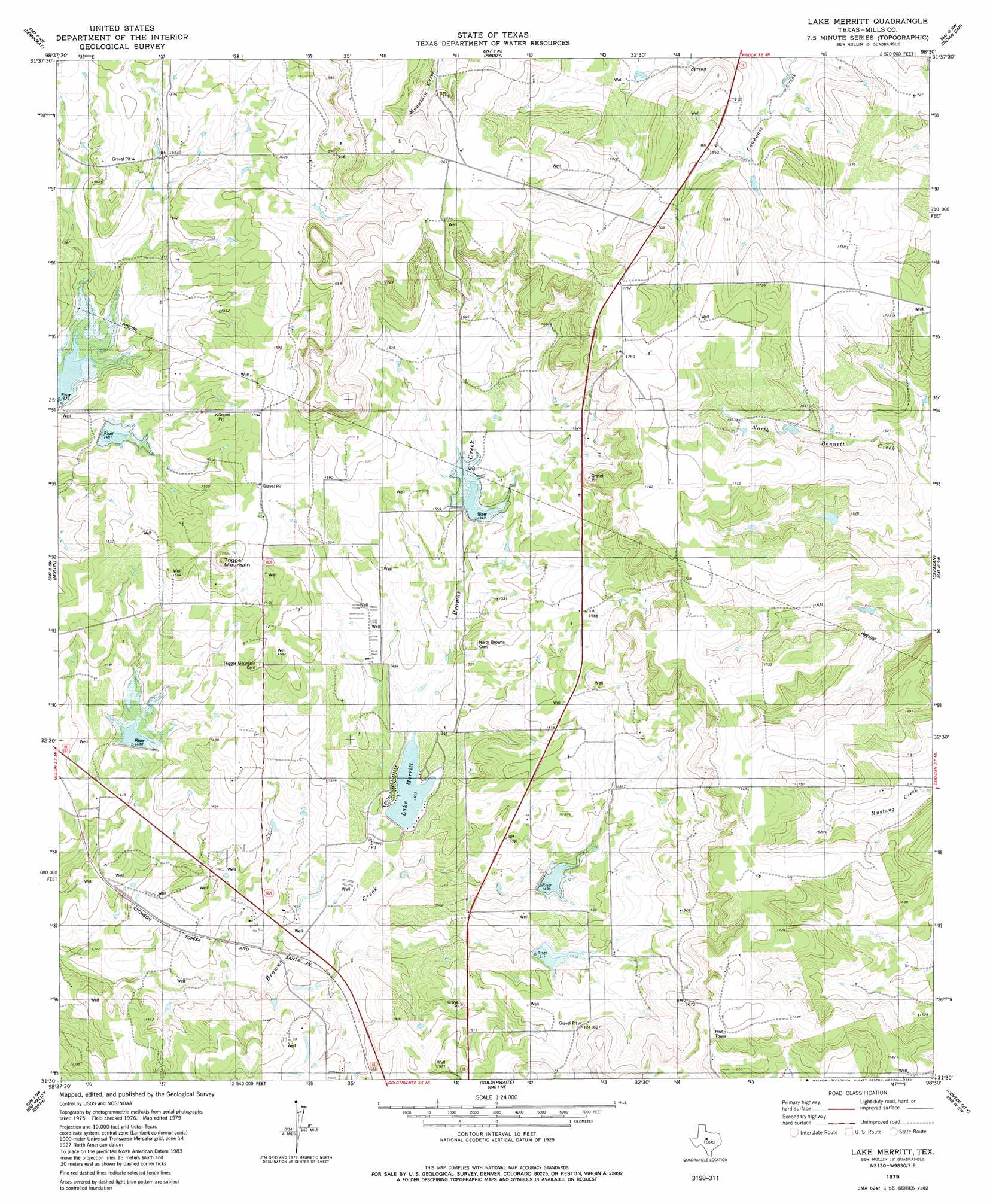
USGS Topo Quad 31098e5 - 1:24,000 scale
| Topo Map Name: | Lake Merritt |
| USGS Topo Quad ID: | 31098e5 |
| Print Size: | ca. 21 1/4" wide x 27" high |
| Southeast Coordinates: | 31.5° N latitude / 98.5° W longitude |
| Map Center Coordinates: | 31.5625° N latitude / 98.5625° W longitude |
| U.S. State: | TX |
| Filename: | o31098e5.jpg |
| Download Map JPG Image: | Lake Merritt topo map 1:24,000 scale |
| Map Type: | Topographic |
| Topo Series: | 7.5´ |
| Map Scale: | 1:24,000 |
| Source of Map Images: | United States Geological Survey (USGS) |
| Alternate Map Versions: |
Lake Merritt TX 1979, updated 1980 Download PDF Buy paper map Lake Merritt TX 2010 Download PDF Buy paper map Lake Merritt TX 2013 Download PDF Buy paper map Lake Merritt TX 2016 Download PDF Buy paper map |
1:24,000 Topo Quads surrounding Lake Merritt
Blanket |
Mercers Gap |
Newburg |
Gustine |
Lamkin |
Zephyr |
Democrat |
Priddy |
Indian Gap |
Pottsville |
Blanket Springs |
Mullin |
Lake Merritt |
Caradan |
Pecan Wells |
Regency |
Big Valley North |
Goldthwaite |
Center City |
Star |
Blucher Mountain |
Big Valley South |
San Saba Peak |
Antelope Gap |
Castle Peak |
> Back to 31098e1 at 1:100,000 scale
> Back to 31098a1 at 1:250,000 scale
> Back to U.S. Topo Maps home
Lake Merritt topo map: Gazetteer
Lake Merritt: Dams
Lake Merritt Dam elevation 437m 1433′Soil Conservation Service Site 3 Dam elevation 452m 1482′
Soil Conservation Service Site 4 Dam elevation 436m 1430′
Soil Conservation Service Site 5a Dam elevation 470m 1541′
Soil Conservation Service Site 6 Dam elevation 449m 1473′
Soil Conservation Service Site 7 Dam elevation 458m 1502′
Lake Merritt: Populated Places
Bozar elevation 433m 1420′Lake Merritt: Reservoirs
Brown Mullin Watershed Reservoir Number Five elevation 470m 1541′Brown Mullin Watershed Reservoir Number Seven elevation 463m 1519′
Brown Mullin Watershed Reservoir Number Six elevation 455m 1492′
Browns Mullin Watershed Reservoir Number Four elevation 456m 1496′
Lake Merritt elevation 443m 1453′
Soil Conservation Service Site 3 Reservoir elevation 452m 1482′
Soil Conservation Service Site 4 Reservoir elevation 436m 1430′
Soil Conservation Service Site 5a Reservoir elevation 470m 1541′
Soil Conservation Service Site 6 Reservoir elevation 449m 1473′
Soil Conservation Service Site 7 Reservoir elevation 458m 1502′
Lake Merritt: Summits
Tiger Mountain elevation 517m 1696′Lake Merritt digital topo map on disk
Buy this Lake Merritt topo map showing relief, roads, GPS coordinates and other geographical features, as a high-resolution digital map file on DVD: