Mullin Topo Map Texas
To zoom in, hover over the map of Mullin
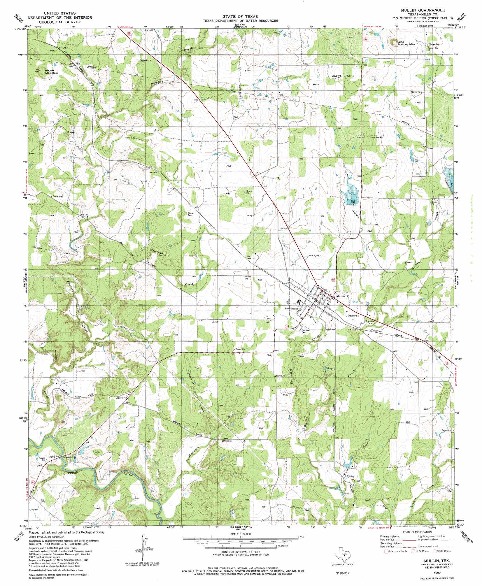
USGS Topo Quad 31098e6 - 1:24,000 scale
| Topo Map Name: | Mullin |
| USGS Topo Quad ID: | 31098e6 |
| Print Size: | ca. 21 1/4" wide x 27" high |
| Southeast Coordinates: | 31.5° N latitude / 98.625° W longitude |
| Map Center Coordinates: | 31.5625° N latitude / 98.6875° W longitude |
| U.S. State: | TX |
| Filename: | o31098e6.jpg |
| Download Map JPG Image: | Mullin topo map 1:24,000 scale |
| Map Type: | Topographic |
| Topo Series: | 7.5´ |
| Map Scale: | 1:24,000 |
| Source of Map Images: | United States Geological Survey (USGS) |
| Alternate Map Versions: |
Mullin TX 1980, updated 1980 Download PDF Buy paper map Mullin TX 2010 Download PDF Buy paper map Mullin TX 2013 Download PDF Buy paper map Mullin TX 2016 Download PDF Buy paper map |
1:24,000 Topo Quads surrounding Mullin
Owens |
Blanket |
Mercers Gap |
Newburg |
Gustine |
Brownwood |
Zephyr |
Democrat |
Priddy |
Indian Gap |
Indian Creek |
Blanket Springs |
Mullin |
Lake Merritt |
Caradan |
Bowser |
Regency |
Big Valley North |
Goldthwaite |
Center City |
Richland Springs |
Blucher Mountain |
Big Valley South |
San Saba Peak |
Antelope Gap |
> Back to 31098e1 at 1:100,000 scale
> Back to 31098a1 at 1:250,000 scale
> Back to U.S. Topo Maps home
Mullin topo map: Gazetteer
Mullin: Bridges
Jackson Bridge elevation 368m 1207′Mullin: Dams
Dennie Shelton Lake Dam elevation 403m 1322′Duren Lake Number 1 Dam elevation 442m 1450′
Murray Lake Dam elevation 388m 1272′
Soil Conservation Service Site 1 Dam elevation 449m 1473′
Soil Conservation Service Site 2 Dam elevation 449m 1473′
Mullin: Populated Places
Mullin elevation 438m 1437′Villa elevation 432m 1417′
Mullin: Reservoirs
Brown Mullin Watershed Reservoir Number Two elevation 449m 1473′Dennie Shelton Lake elevation 403m 1322′
Duren Lake Number 1 elevation 442m 1450′
Murray Lake elevation 388m 1272′
Soil Conservation Service Site 1 Reservoir elevation 449m 1473′
Soil Conservation Service Site 2 Reservoir elevation 449m 1473′
Mullin: Streams
Blanket Creek elevation 369m 1210′Bookwater Creek elevation 402m 1318′
Hampton Creek elevation 366m 1200′
Herd Pen Branch elevation 396m 1299′
Peppermint Creek elevation 388m 1272′
Pompey Creek elevation 375m 1230′
Willoughby Creek elevation 379m 1243′
Mullin: Summits
Little Pompey Mountain elevation 530m 1738′Round Mountain elevation 470m 1541′
Mullin: Valleys
King Hollow elevation 369m 1210′Long Hollow elevation 421m 1381′
Mullin digital topo map on disk
Buy this Mullin topo map showing relief, roads, GPS coordinates and other geographical features, as a high-resolution digital map file on DVD: