Eden Topo Map Texas
To zoom in, hover over the map of Eden
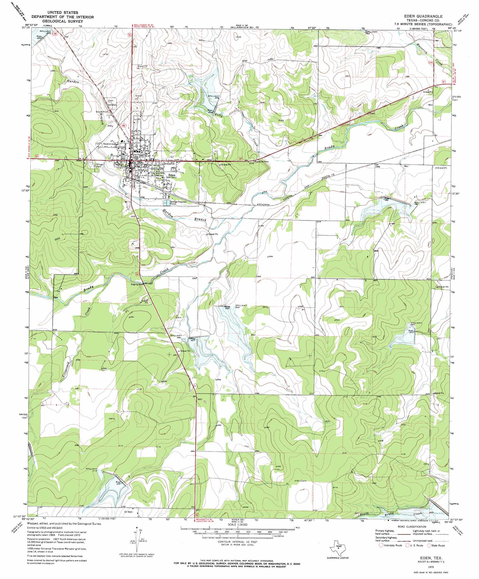
USGS Topo Quad 31099b7 - 1:24,000 scale
| Topo Map Name: | Eden |
| USGS Topo Quad ID: | 31099b7 |
| Print Size: | ca. 21 1/4" wide x 27" high |
| Southeast Coordinates: | 31.125° N latitude / 99.75° W longitude |
| Map Center Coordinates: | 31.1875° N latitude / 99.8125° W longitude |
| U.S. State: | TX |
| Filename: | o31099b7.jpg |
| Download Map JPG Image: | Eden topo map 1:24,000 scale |
| Map Type: | Topographic |
| Topo Series: | 7.5´ |
| Map Scale: | 1:24,000 |
| Source of Map Images: | United States Geological Survey (USGS) |
| Alternate Map Versions: |
Eden TX 1970, updated 1973 Download PDF Buy paper map Eden TX 2010 Download PDF Buy paper map Eden TX 2013 Download PDF Buy paper map Eden TX 2016 Download PDF Buy paper map |
1:24,000 Topo Quads surrounding Eden
Eola |
Millersview Nw |
Millersview |
Mustang Creek |
Doole |
Vick |
Millersview Sw |
Millersview Se |
Doole Sw |
Salt Gap |
Burr Oak Creek |
Live Oak |
Eden |
Pasche |
Melvin |
Del Venado Ranch |
Eden Sw |
Eden Se |
Callan |
Needle Creek |
Fort Mckavett Ne |
Clear Creek Lake |
Menard |
Chapman Draw |
Robbers Roost |
> Back to 31099a1 at 1:100,000 scale
> Back to 31098a1 at 1:250,000 scale
> Back to U.S. Topo Maps home
Eden topo map: Gazetteer
Eden: Dams
Soil Conservation Service Site 22 Dam elevation 611m 2004′Soil Conservation Service Site 23 Dam elevation 606m 1988′
Soil Conservation Service Site 24 Dam elevation 619m 2030′
Soil Conservation Service Site 25 Dam elevation 615m 2017′
Soil Conservation Service Site 27 Dam elevation 638m 2093′
Soil Conservation Service Site 34 Dam elevation 630m 2066′
Soil Conservation Service Site 35 Dam elevation 616m 2020′
Eden: Parks
Pfluger Park elevation 620m 2034′Eden: Populated Places
Eden elevation 626m 2053′Eden: Reservoirs
Soil Conservation Service Site 22 Reservoir elevation 611m 2004′Soil Conservation Service Site 23 Reservoir elevation 606m 1988′
Soil Conservation Service Site 24 Reservoir elevation 619m 2030′
Soil Conservation Service Site 25 Reservoir elevation 615m 2017′
Soil Conservation Service Site 27 Reservoir elevation 638m 2093′
Soil Conservation Service Site 34 Reservoir elevation 630m 2066′
Soil Conservation Service Site 35 Reservoir elevation 616m 2020′
Eden: Streams
Fitzgerald Creek elevation 613m 2011′Harden Branch elevation 604m 1981′
Kelly Creek elevation 598m 1961′
Eden digital topo map on disk
Buy this Eden topo map showing relief, roads, GPS coordinates and other geographical features, as a high-resolution digital map file on DVD: