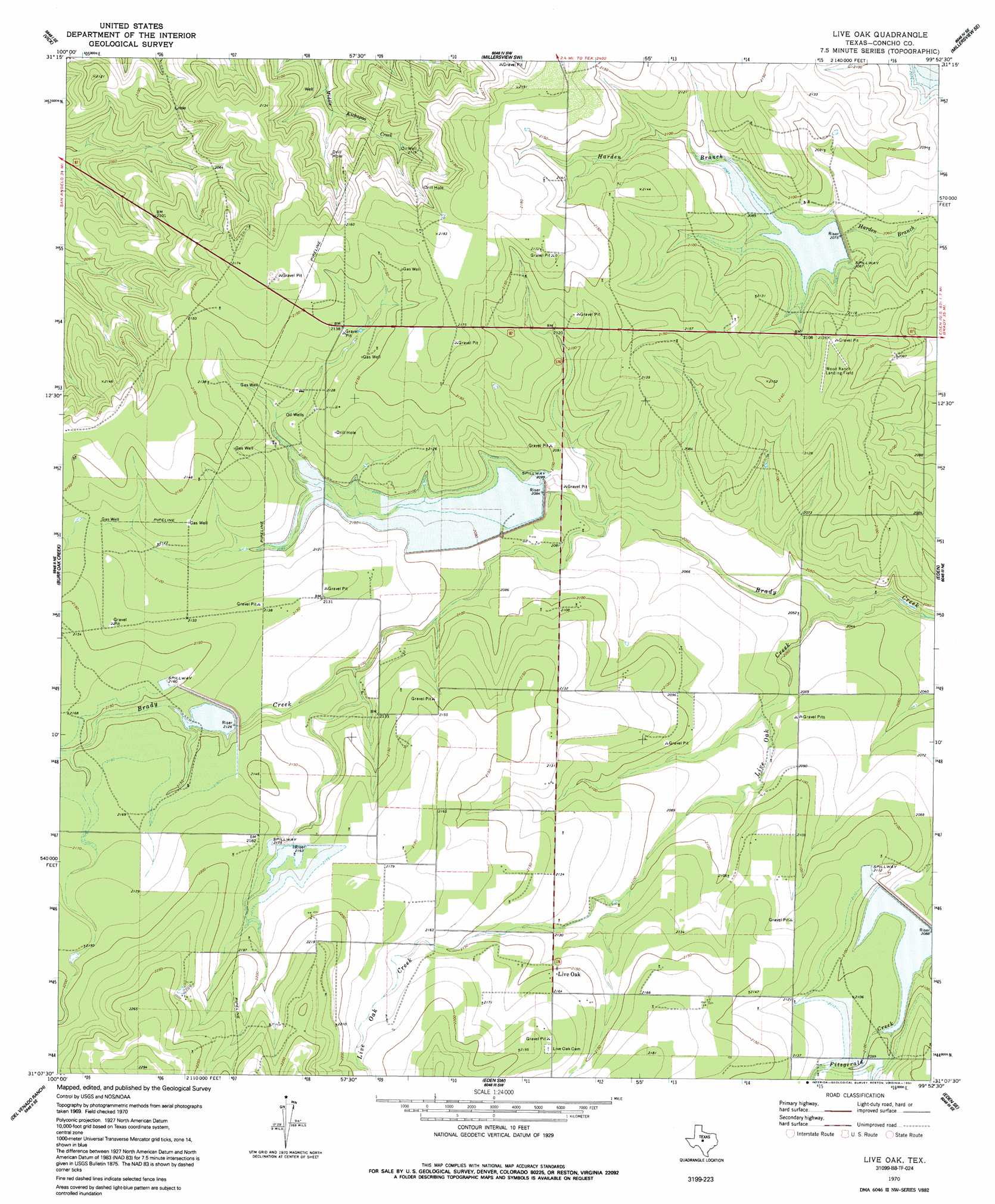
Live Oak Topo Map Texas
To zoom in, hover over the map of Live Oak
USGS Topo Quad 31099b8 - 1:24,000 scale
| Topo Map Name: | Live Oak |
| USGS Topo Quad ID: | 31099b8 |
| Print Size: | ca. 21 1/4" wide x 27" high |
| Southeast Coordinates: | 31.125° N latitude / 99.875° W longitude |
| Map Center Coordinates: | 31.1875° N latitude / 99.9375° W longitude |
| U.S. State: | TX |
| Filename: | o31099b8.jpg |
| Download Map JPG Image: | Live Oak topo map 1:24,000 scale |
| Map Type: | Topographic |
| Topo Series: | 7.5´ |
| Map Scale: | 1:24,000 |
| Source of Map Images: | United States Geological Survey (USGS) |
| Alternate Map Versions: |
Live Oak TX 1970, updated 1973 Download PDF Buy paper map Live Oak TX 1970, updated 1991 Download PDF Buy paper map Live Oak TX 2010 Download PDF Buy paper map Live Oak TX 2013 Download PDF Buy paper map Live Oak TX 2016 Download PDF Buy paper map |
1:24,000 Topo Quads surrounding Live Oak
Mereta |
Eola |
Millersview Nw |
Millersview |
Mustang Creek |
Vancourt |
Vick |
Millersview Sw |
Millersview Se |
Doole Sw |
Kickapoo Spring |
Burr Oak Creek |
Live Oak |
Eden |
Pasche |
Rocking Chair Ranch |
Del Venado Ranch |
Eden Sw |
Eden Se |
Callan |
Fort Mckavett Nw |
Fort Mckavett Ne |
Clear Creek Lake |
Menard |
Chapman Draw |
> Back to 31099a1 at 1:100,000 scale
> Back to 31098a1 at 1:250,000 scale
> Back to U.S. Topo Maps home
Live Oak topo map: Gazetteer
Live Oak: Dams
Soil Conservation Service Site 28 Dam elevation 634m 2080′Soil Conservation Service Site 30 Dam elevation 662m 2171′
Soil Conservation Service Site 31 Dam elevation 650m 2132′
Soil Conservation Service Site 32 Dam elevation 636m 2086′
Soil Conservation Service Site 33 Dam elevation 636m 2086′
Live Oak: Populated Places
Live Oak elevation 654m 2145′Live Oak: Reservoirs
Soil Conservation Service Site 28 Reservoir elevation 634m 2080′Soil Conservation Service Site 30 Reservoir elevation 662m 2171′
Soil Conservation Service Site 31 Reservoir elevation 650m 2132′
Soil Conservation Service Site 32 Reservoir elevation 636m 2086′
Soil Conservation Service Site 33 Reservoir elevation 636m 2086′
Live Oak: Streams
Live Oak Creek elevation 619m 2030′Live Oak digital topo map on disk
Buy this Live Oak topo map showing relief, roads, GPS coordinates and other geographical features, as a high-resolution digital map file on DVD: