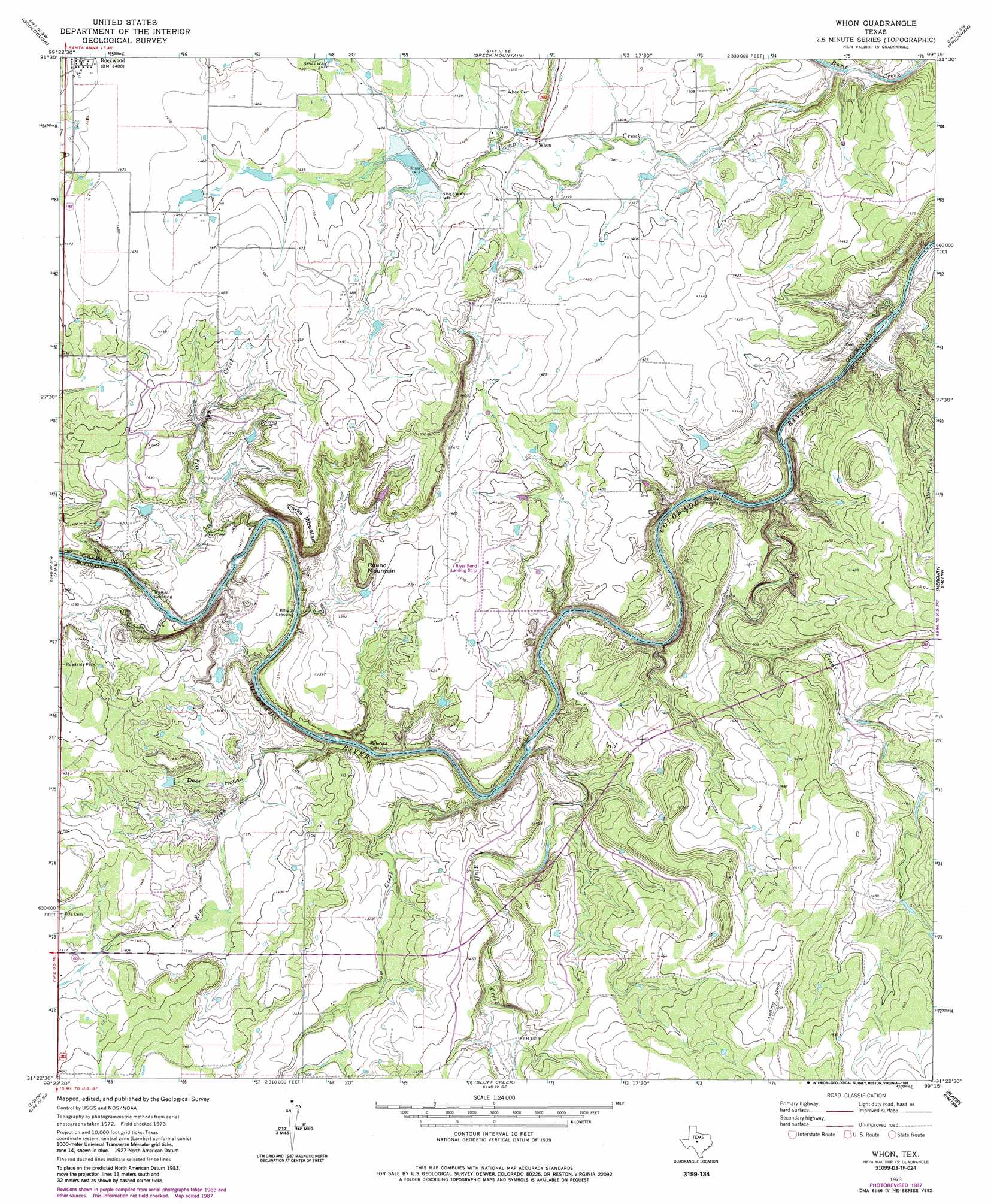
Whon Topo Map Texas
To zoom in, hover over the map of Whon
USGS Topo Quad 31099d3 - 1:24,000 scale
| Topo Map Name: | Whon |
| USGS Topo Quad ID: | 31099d3 |
| Print Size: | ca. 21 1/4" wide x 27" high |
| Southeast Coordinates: | 31.375° N latitude / 99.25° W longitude |
| Map Center Coordinates: | 31.4375° N latitude / 99.3125° W longitude |
| U.S. State: | TX |
| Filename: | o31099d3.jpg |
| Download Map JPG Image: | Whon topo map 1:24,000 scale |
| Map Type: | Topographic |
| Topo Series: | 7.5´ |
| Map Scale: | 1:24,000 |
| Source of Map Images: | United States Geological Survey (USGS) |
| Alternate Map Versions: |
Whon TX 1973, updated 1976 Download PDF Buy paper map Whon TX 1973, updated 1988 Download PDF Buy paper map Whon TX 2010 Download PDF Buy paper map Whon TX 2013 Download PDF Buy paper map Whon TX 2016 Download PDF Buy paper map |
1:24,000 Topo Quads surrounding Whon
Bead Mountain |
Fisk |
Santa Anna |
Bangs West |
Bangs East |
Voss |
Gouldbusk |
Speck Mountain |
Trickham |
Brookesmith |
Doole |
Fife |
Whon |
Mercury |
Elm Grove |
Salt Gap |
Lohn |
Bluff Creek |
Placid |
Hall |
Melvin |
West Sweden |
Brady North |
Rochelle |
Lost Creek |
> Back to 31099a1 at 1:100,000 scale
> Back to 31098a1 at 1:250,000 scale
> Back to U.S. Topo Maps home
Whon topo map: Gazetteer
Whon: Airports
River Bend Ranch Airport elevation 437m 1433′Whon: Dams
Soil Conservation Service Site 22 Dam elevation 425m 1394′Whon: Populated Places
Knight Crossing elevation 407m 1335′Military Crossing elevation 398m 1305′
Mitchell Crossing elevation 402m 1318′
Walker Crossing elevation 405m 1328′
Whon elevation 424m 1391′
Whon: Reservoirs
Soil Conservation Service Site 22 Reservoir elevation 425m 1394′Whon: Streams
Bluff Creek elevation 409m 1341′Camp Creek elevation 404m 1325′
Cedar Creek elevation 399m 1309′
Cow Creek elevation 401m 1315′
Elm Creek elevation 400m 1312′
Old Boggy Creek elevation 405m 1328′
Tom Dean Creek elevation 398m 1305′
Whon: Summits
Parks Mountain elevation 461m 1512′Round Mountain elevation 446m 1463′
Whon: Valleys
Deer Hollow elevation 405m 1328′Whon digital topo map on disk
Buy this Whon topo map showing relief, roads, GPS coordinates and other geographical features, as a high-resolution digital map file on DVD: