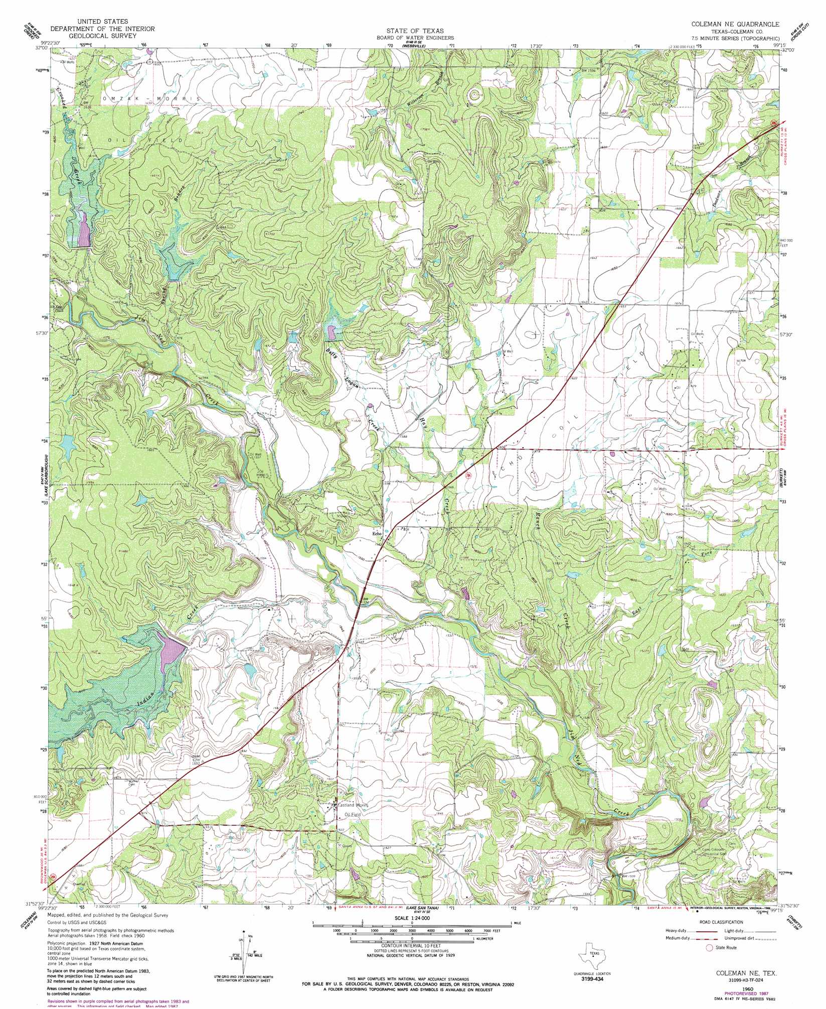
Coleman Ne Topo Map Texas
To zoom in, hover over the map of Coleman Ne
USGS Topo Quad 31099h3 - 1:24,000 scale
| Topo Map Name: | Coleman Ne |
| USGS Topo Quad ID: | 31099h3 |
| Print Size: | ca. 21 1/4" wide x 27" high |
| Southeast Coordinates: | 31.875° N latitude / 99.25° W longitude |
| Map Center Coordinates: | 31.9375° N latitude / 99.3125° W longitude |
| U.S. State: | TX |
| Filename: | o31099h3.jpg |
| Download Map JPG Image: | Coleman Ne topo map 1:24,000 scale |
| Map Type: | Topographic |
| Topo Series: | 7.5´ |
| Map Scale: | 1:24,000 |
| Source of Map Images: | United States Geological Survey (USGS) |
| Alternate Map Versions: |
Coleman NE TX 1960, updated 1962 Download PDF Buy paper map Coleman NE TX 1960, updated 1975 Download PDF Buy paper map Coleman NE TX 1960, updated 1988 Download PDF Buy paper map Coleman NE TX 2010 Download PDF Buy paper map Coleman NE TX 2012 Download PDF Buy paper map Coleman NE TX 2016 Download PDF Buy paper map |
1:24,000 Topo Quads surrounding Coleman Ne
Oplin |
Rowden Nw |
Rowden |
Cross Plains North |
Sabanno |
Mcewen Draw |
Crooked Creek |
Webbville |
Cross Cut |
Pioneer |
Novice East |
Lake Scarborough |
Coleman Ne |
Burkett |
Byrds |
Valera |
Coleman |
Lake San Tana |
Thrifty |
Lake Brownwood |
Bead Mountain |
Fisk |
Santa Anna |
Bangs West |
Bangs East |
> Back to 31099e1 at 1:100,000 scale
> Back to 31098a1 at 1:250,000 scale
> Back to U.S. Topo Maps home
Coleman Ne topo map: Gazetteer
Coleman Ne: Dams
Soil Conservation Service Site 25 Dam elevation 487m 1597′Soil Conservation Service Site 5 Dam elevation 503m 1650′
Soil Conservation Service Site 6 Dam elevation 490m 1607′
Soil Conservation Service Site 7 Dam elevation 489m 1604′
Coleman Ne: Oilfields
Eastland Morris Oil Field elevation 498m 1633′Echo Oil Field elevation 496m 1627′
Coleman Ne: Populated Places
Echo elevation 478m 1568′Coleman Ne: Reservoirs
Soil Conservation Service Site 25 Reservoir elevation 487m 1597′Soil Conservation Service Site 5 Reservoir elevation 503m 1650′
Soil Conservation Service Site 6 Reservoir elevation 490m 1607′
Soil Conservation Service Site 7 Reservoir elevation 489m 1604′
Coleman Ne: Streams
Betty Logan Creek elevation 475m 1558′Cow Creek elevation 478m 1568′
Crooked Creek elevation 480m 1574′
East Fork Ranch Creek elevation 466m 1528′
Hay Creek elevation 462m 1515′
Indian Creek elevation 466m 1528′
Ranch Creek elevation 460m 1509′
Spring Branch elevation 475m 1558′
Coleman Ne digital topo map on disk
Buy this Coleman Ne topo map showing relief, roads, GPS coordinates and other geographical features, as a high-resolution digital map file on DVD: