Twin Buttes Topo Map Texas
To zoom in, hover over the map of Twin Buttes
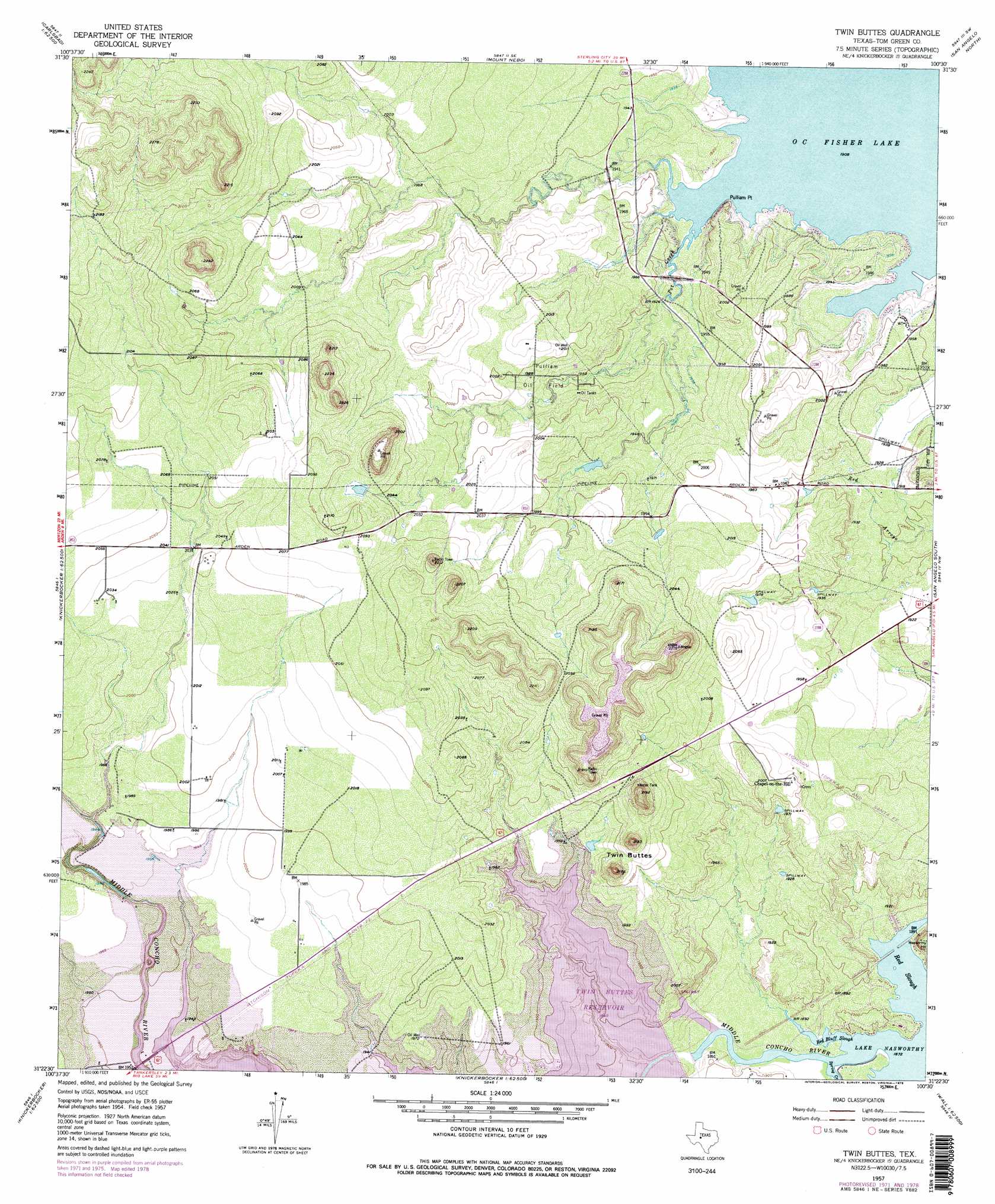
USGS Topo Quad 31100d5 - 1:24,000 scale
| Topo Map Name: | Twin Buttes |
| USGS Topo Quad ID: | 31100d5 |
| Print Size: | ca. 21 1/4" wide x 27" high |
| Southeast Coordinates: | 31.375° N latitude / 100.5° W longitude |
| Map Center Coordinates: | 31.4375° N latitude / 100.5625° W longitude |
| U.S. State: | TX |
| Filename: | o31100d5.jpg |
| Download Map JPG Image: | Twin Buttes topo map 1:24,000 scale |
| Map Type: | Topographic |
| Topo Series: | 7.5´ |
| Map Scale: | 1:24,000 |
| Source of Map Images: | United States Geological Survey (USGS) |
| Alternate Map Versions: |
Twin Buttes TX 1957, updated 1958 Download PDF Buy paper map Twin Buttes TX 1957, updated 1973 Download PDF Buy paper map Twin Buttes TX 1957, updated 1978 Download PDF Buy paper map Twin Buttes TX 1957, updated 1978 Download PDF Buy paper map Twin Buttes TX 2010 Download PDF Buy paper map Twin Buttes TX 2013 Download PDF Buy paper map Twin Buttes TX 2016 Download PDF Buy paper map |
1:24,000 Topo Quads surrounding Twin Buttes
Dog Creek Ne |
Water Valley |
Murph Draw |
Pecan Mott |
Tennyson |
Dog Creek |
Carlsbad |
Mount Nebo |
San Angelo North |
Harriet |
Arden |
Knickerbocker Nw |
Twin Buttes |
San Angelo South |
Veribest |
Mertzon |
Tankersley |
Knickerbocker |
Pecan Station |
Wall |
Noelke Ne |
Hulldale Nw |
Cold Creek Spring |
Christoval |
Susan Peak |
> Back to 31100a1 at 1:100,000 scale
> Back to 31100a1 at 1:250,000 scale
> Back to U.S. Topo Maps home
Twin Buttes topo map: Gazetteer
Twin Buttes: Capes
Pulliam Point elevation 590m 1935′Twin Buttes: Dams
Twin Buttes Dam elevation 573m 1879′Twin Buttes: Guts
Red Bluff Slough elevation 571m 1873′Red Slough elevation 571m 1873′
Twin Buttes: Oilfields
Pulliam Oil Field elevation 604m 1981′Twin Buttes: Parks
Lincoln Park elevation 573m 1879′Red Bluff Park elevation 581m 1906′
San Angelo State Park - South Shore elevation 598m 1961′
Twin Buttes: Reservoirs
Twin Buttes Reservoir elevation 592m 1942′Twin Buttes: Streams
Middle Concho River elevation 571m 1873′Pot Creek elevation 581m 1906′
Twin Buttes: Summits
Twin Buttes elevation 615m 2017′Twin Buttes: Trails
San Angelo State Park Trail elevation 591m 1938′Twin Buttes digital topo map on disk
Buy this Twin Buttes topo map showing relief, roads, GPS coordinates and other geographical features, as a high-resolution digital map file on DVD: