Millican Mountains Topo Map Texas
To zoom in, hover over the map of Millican Mountains
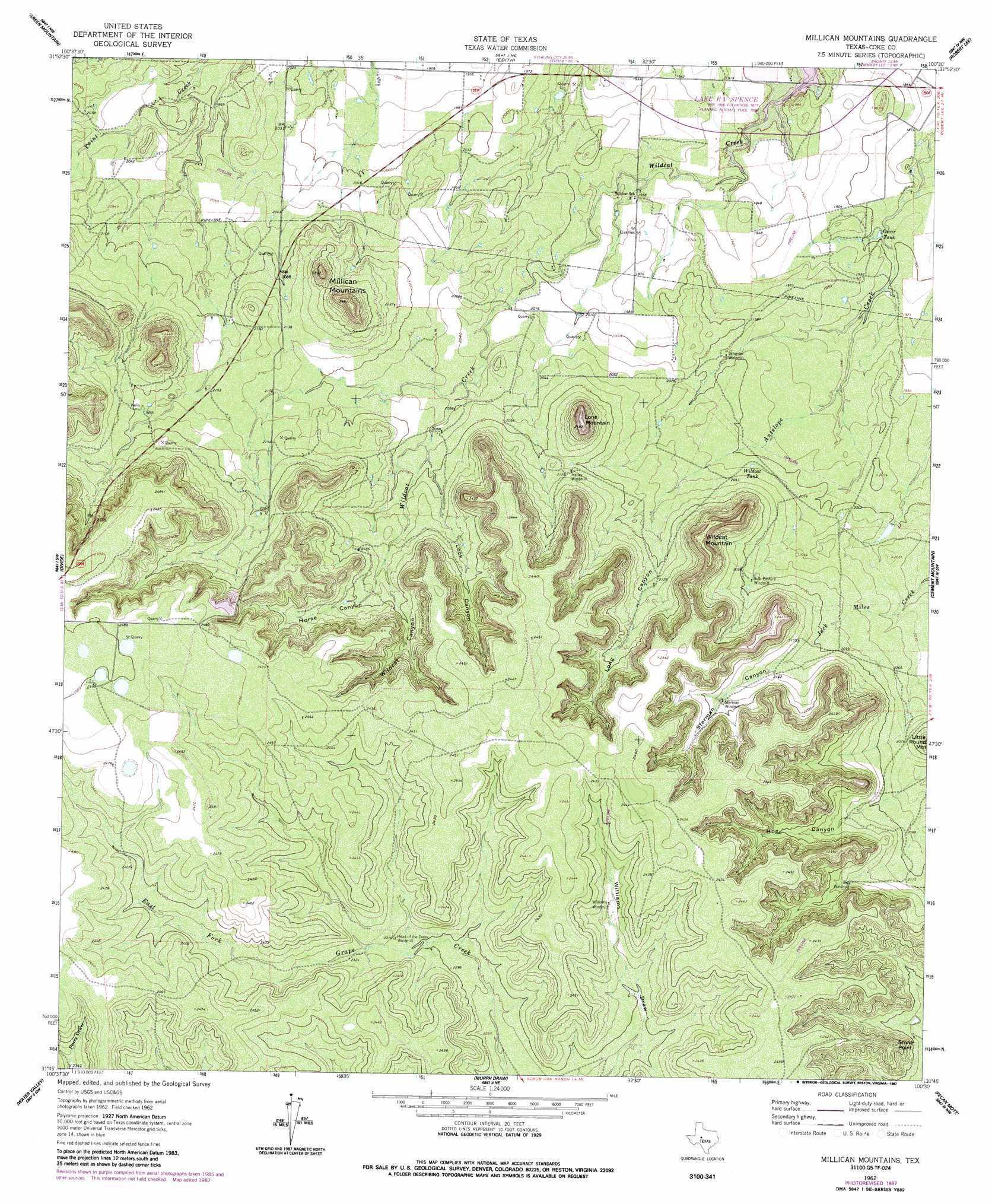
USGS Topo Quad 31100g5 - 1:24,000 scale
| Topo Map Name: | Millican Mountains |
| USGS Topo Quad ID: | 31100g5 |
| Print Size: | ca. 21 1/4" wide x 27" high |
| Southeast Coordinates: | 31.75° N latitude / 100.5° W longitude |
| Map Center Coordinates: | 31.8125° N latitude / 100.5625° W longitude |
| U.S. State: | TX |
| Filename: | o31100g5.jpg |
| Download Map JPG Image: | Millican Mountains topo map 1:24,000 scale |
| Map Type: | Topographic |
| Topo Series: | 7.5´ |
| Map Scale: | 1:24,000 |
| Source of Map Images: | United States Geological Survey (USGS) |
| Alternate Map Versions: |
Millican Mountains TX 1962, updated 1964 Download PDF Buy paper map Millican Mountains TX 1962, updated 1987 Download PDF Buy paper map Millican Mountains TX 2010 Download PDF Buy paper map Millican Mountains TX 2012 Download PDF Buy paper map Millican Mountains TX 2016 Download PDF Buy paper map |
1:24,000 Topo Quads surrounding Millican Mountains
Dead Indian Mountain |
Silver |
Sanco |
Blackwell Sw |
Blackwell |
Crawford Slide |
Green Mountain |
Edith |
Robert Lee |
Bronte |
Broome |
Divide |
Millican Mountains |
Cement Mountain |
Shawville |
Dog Creek Ne |
Water Valley |
Murph Draw |
Pecan Mott |
Tennyson |
Dog Creek |
Carlsbad |
Mount Nebo |
San Angelo North |
Harriet |
> Back to 31100e1 at 1:100,000 scale
> Back to 31100a1 at 1:250,000 scale
> Back to U.S. Topo Maps home
Millican Mountains topo map: Gazetteer
Millican Mountains: Arroyos
Perry Draw elevation 744m 2440′Millican Mountains: Capes
Stone Point elevation 728m 2388′Millican Mountains: Reservoirs
E V Spence Reservoir elevation 591m 1938′Oscar Tank elevation 574m 1883′
Wildcat Tank elevation 613m 2011′
Millican Mountains: Summits
Lone Mountain elevation 735m 2411′Millican Mountains elevation 676m 2217′
Wildcat Mountain elevation 740m 2427′
Millican Mountains: Valleys
Hog Canyon elevation 637m 2089′Horse Canyon elevation 661m 2168′
Lock Canyon elevation 638m 2093′
Long Canyon elevation 629m 2063′
Sterman Canyon elevation 641m 2103′
Wildcat Canyon elevation 667m 2188′
Millican Mountains digital topo map on disk
Buy this Millican Mountains topo map showing relief, roads, GPS coordinates and other geographical features, as a high-resolution digital map file on DVD: