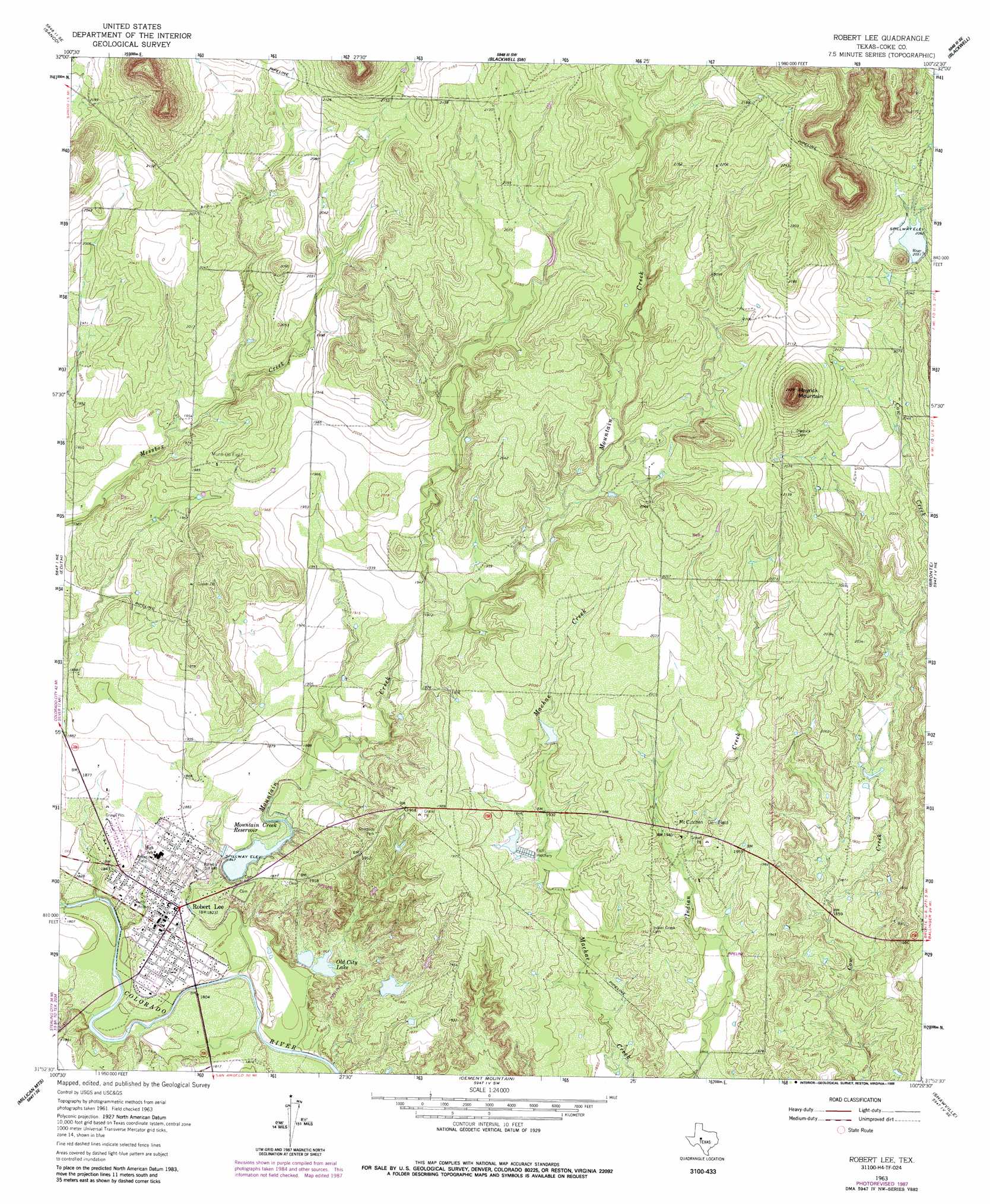
Robert Lee Topo Map Texas
To zoom in, hover over the map of Robert Lee
USGS Topo Quad 31100h4 - 1:24,000 scale
| Topo Map Name: | Robert Lee |
| USGS Topo Quad ID: | 31100h4 |
| Print Size: | ca. 21 1/4" wide x 27" high |
| Southeast Coordinates: | 31.875° N latitude / 100.375° W longitude |
| Map Center Coordinates: | 31.9375° N latitude / 100.4375° W longitude |
| U.S. State: | TX |
| Filename: | o31100h4.jpg |
| Download Map JPG Image: | Robert Lee topo map 1:24,000 scale |
| Map Type: | Topographic |
| Topo Series: | 7.5´ |
| Map Scale: | 1:24,000 |
| Source of Map Images: | United States Geological Survey (USGS) |
| Alternate Map Versions: |
Robert Lee TX 1963, updated 1964 Download PDF Buy paper map Robert Lee TX 1963, updated 1988 Download PDF Buy paper map Robert Lee TX 2010 Download PDF Buy paper map Robert Lee TX 2012 Download PDF Buy paper map Robert Lee TX 2016 Download PDF Buy paper map |
1:24,000 Topo Quads surrounding Robert Lee
Dam Draw |
Dew Drop Creek |
Maryneal |
Blackwell Ne |
Hylton |
Silver |
Sanco |
Blackwell Sw |
Blackwell |
Church Peak |
Green Mountain |
Edith |
Robert Lee |
Bronte |
Hog Mountain |
Divide |
Millican Mountains |
Cement Mountain |
Shawville |
Maverick |
Water Valley |
Murph Draw |
Pecan Mott |
Tennyson |
Miles Nw |
> Back to 31100e1 at 1:100,000 scale
> Back to 31100a1 at 1:250,000 scale
> Back to U.S. Topo Maps home
Robert Lee topo map: Gazetteer
Robert Lee: Dams
Mountain Creek Dam elevation 563m 1847′Old City Lake Dam elevation 547m 1794′
Soil Conservation Service Site 1 Dam elevation 627m 2057′
Robert Lee: Oilfields
McCuthen Oil Field elevation 592m 1942′Munn Oil Field elevation 610m 2001′
Robert Lee: Populated Places
Robert Lee elevation 557m 1827′Robert Lee: Reservoirs
Mountain Creek Reservoir elevation 563m 1847′Old City Lake elevation 555m 1820′
Soil Conservation Service Site 1 Reservoir elevation 627m 2057′
Robert Lee: Streams
Messbox Creek elevation 548m 1797′Mountain Creek elevation 540m 1771′
Robert Lee: Summits
Hayrick Mountain elevation 729m 2391′Robert Lee digital topo map on disk
Buy this Robert Lee topo map showing relief, roads, GPS coordinates and other geographical features, as a high-resolution digital map file on DVD: