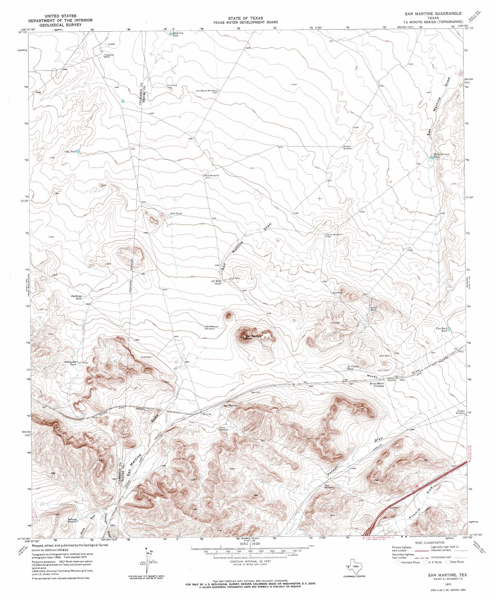
San Martine Topo Map Texas
To zoom in, hover over the map of San Martine
USGS Topo Quad 31104b1 - 1:24,000 scale
| Topo Map Name: | San Martine |
| USGS Topo Quad ID: | 31104b1 |
| Print Size: | ca. 21 1/4" wide x 27" high |
| Southeast Coordinates: | 31.125° N latitude / 104° W longitude |
| Map Center Coordinates: | 31.1875° N latitude / 104.0625° W longitude |
| U.S. State: | TX |
| Filename: | o31104b1.jpg |
| Download Map JPG Image: | San Martine topo map 1:24,000 scale |
| Map Type: | Topographic |
| Topo Series: | 7.5´ |
| Map Scale: | 1:24,000 |
| Source of Map Images: | United States Geological Survey (USGS) |
| Alternate Map Versions: |
San Martine TX 1970, updated 1973 Download PDF Buy paper map San Martine TX 2010 Download PDF Buy paper map San Martine TX 2013 Download PDF Buy paper map San Martine TX 2016 Download PDF Buy paper map |
1:24,000 Topo Quads surrounding San Martine
Dellahunt Draw West |
Dellahunt Draw East |
Burnt Spring Hills |
Toyah Nw |
Big Hill |
Hopper Draw West |
Hopper Draw East |
Burnt Spring Hills Se |
Toyah Sw |
Toyah |
Panther Canyon |
Iron Mountain |
San Martine |
Gozar |
Florenzo Hill |
Fencepost Draw |
Kent |
Gomez Peak |
Sotol Hill |
Meier Hills |
Herds Pass |
Echo Canyon |
Buckhorn Mountain |
Antelope Flat |
Toyahvale |
> Back to 31104a1 at 1:100,000 scale
> Back to 31104a1 at 1:250,000 scale
> Back to U.S. Topo Maps home
San Martine topo map: Gazetteer
San Martine: Populated Places
San Martine elevation 1134m 3720′Seven Heart Crossing elevation 1100m 3608′
San Martine: Reservoirs
Axtell Tank elevation 1087m 3566′Bull Tank elevation 1081m 3546′
Challenge Tank elevation 1101m 3612′
Clay Tank elevation 1068m 3503′
Dead Cow Tank elevation 1041m 3415′
Goldwater Tank elevation 1128m 3700′
Ice Cream Tank elevation 1108m 3635′
Oil Well Tank elevation 1098m 3602′
Three Corners Tank elevation 1027m 3369′
Two Duck Tank elevation 1068m 3503′
San Martine: Summits
San Martine Peak elevation 1222m 4009′San Martine: Valleys
Adobe Draw elevation 1158m 3799′Antelope Draw elevation 1159m 3802′
Moody Draw elevation 1079m 3540′
San Martine Draw elevation 1071m 3513′
San Martine digital topo map on disk
Buy this San Martine topo map showing relief, roads, GPS coordinates and other geographical features, as a high-resolution digital map file on DVD: