Iron Mountain Topo Map Texas
To zoom in, hover over the map of Iron Mountain
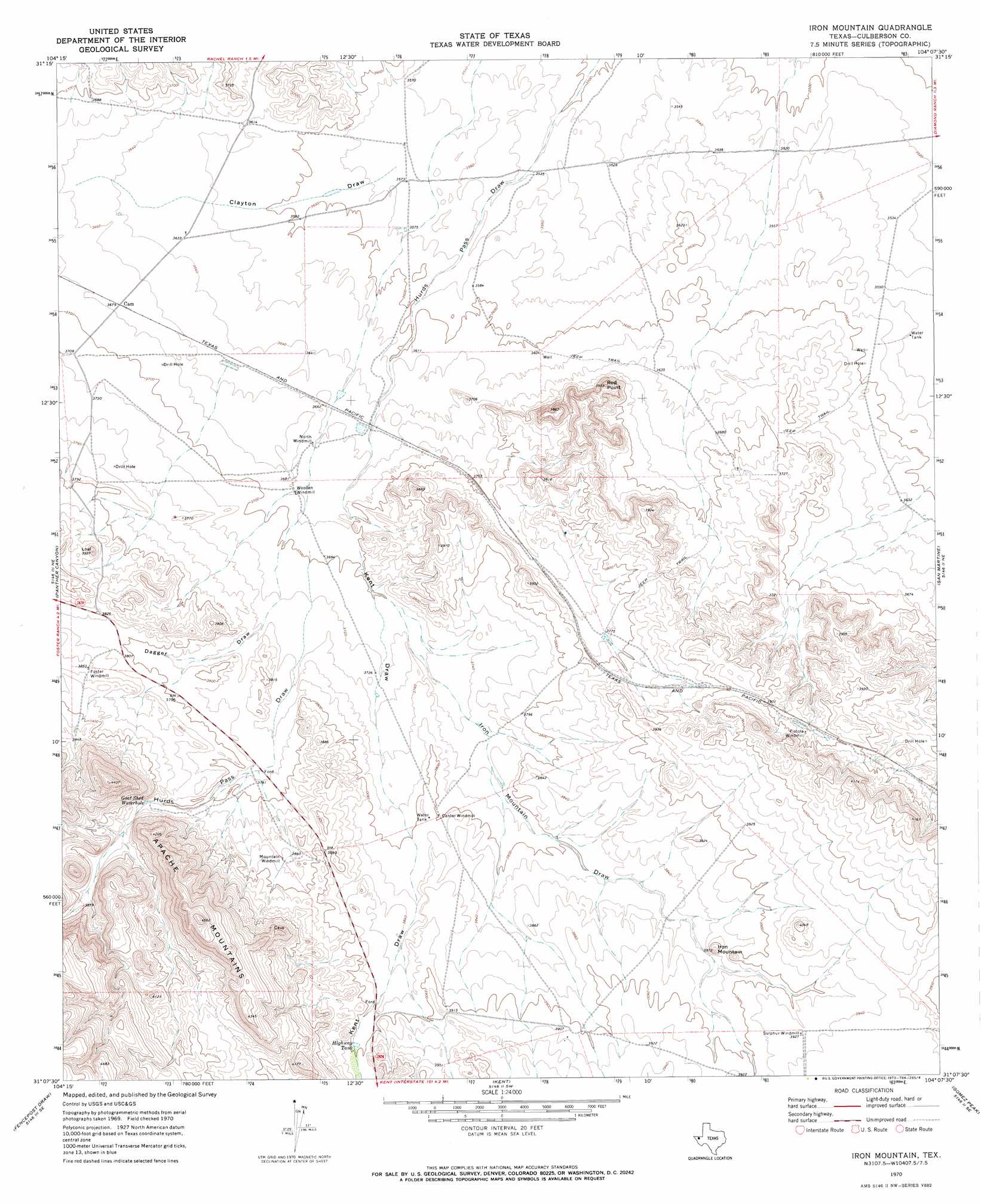
USGS Topo Quad 31104b2 - 1:24,000 scale
| Topo Map Name: | Iron Mountain |
| USGS Topo Quad ID: | 31104b2 |
| Print Size: | ca. 21 1/4" wide x 27" high |
| Southeast Coordinates: | 31.125° N latitude / 104.125° W longitude |
| Map Center Coordinates: | 31.1875° N latitude / 104.1875° W longitude |
| U.S. State: | TX |
| Filename: | o31104b2.jpg |
| Download Map JPG Image: | Iron Mountain topo map 1:24,000 scale |
| Map Type: | Topographic |
| Topo Series: | 7.5´ |
| Map Scale: | 1:24,000 |
| Source of Map Images: | United States Geological Survey (USGS) |
| Alternate Map Versions: |
Iron Mountain TX 1970, updated 1973 Download PDF Buy paper map Iron Mountain TX 2010 Download PDF Buy paper map Iron Mountain TX 2012 Download PDF Buy paper map Iron Mountain TX 2016 Download PDF Buy paper map |
1:24,000 Topo Quads surrounding Iron Mountain
Loneman Mountain |
Dellahunt Draw West |
Dellahunt Draw East |
Burnt Spring Hills |
Toyah Nw |
Dome Hill |
Hopper Draw West |
Hopper Draw East |
Burnt Spring Hills Se |
Toyah Sw |
East Hunter Canyon |
Panther Canyon |
Iron Mountain |
San Martine |
Gozar |
Boracho |
Fencepost Draw |
Kent |
Gomez Peak |
Sotol Hill |
Boracho Peak |
Herds Pass |
Echo Canyon |
Buckhorn Mountain |
Antelope Flat |
> Back to 31104a1 at 1:100,000 scale
> Back to 31104a1 at 1:250,000 scale
> Back to U.S. Topo Maps home
Iron Mountain topo map: Gazetteer
Iron Mountain: Cliffs
Red Point elevation 1174m 3851′Iron Mountain: Lakes
Goat Shed Waterhole elevation 1162m 3812′Iron Mountain: Reservoirs
Highway Tank elevation 1188m 3897′Iron Mountain: Summits
Iron Mountain elevation 1200m 3937′Iron Mountain: Valleys
Clayton Draw elevation 1090m 3576′Dagger Draw elevation 1138m 3733′
Iron Mountain Draw elevation 1134m 3720′
Kent Draw elevation 1128m 3700′
Iron Mountain digital topo map on disk
Buy this Iron Mountain topo map showing relief, roads, GPS coordinates and other geographical features, as a high-resolution digital map file on DVD: